Ilmenau
| Ilmenau | ||
|---|---|---|
|
Ilmenau in winter | ||
| ||
 Ilmenau | ||
Location of Ilmenau within Ilm-Kreis district 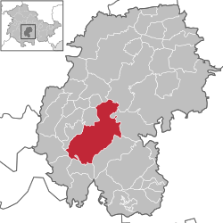 | ||
| Coordinates: 50°41′02″N 10°55′10″E / 50.68389°N 10.91944°ECoordinates: 50°41′02″N 10°55′10″E / 50.68389°N 10.91944°E | ||
| Country | Germany | |
| State | Thuringia | |
| District | Ilm-Kreis | |
| Government | ||
| • Mayor | Gerd-Michael Seeber (CDU) | |
| Area | ||
| • Total | 62.64 km2 (24.19 sq mi) | |
| Population (2015-12-31)[1] | ||
| • Total | 26,153 | |
| • Density | 420/km2 (1,100/sq mi) | |
| Time zone | CET/CEST (UTC+1/+2) | |
| Postal codes | 98693 | |
| Dialling codes | 03677 | |
| Vehicle registration | IK, ARN, IL | |
| Website | www.ilmenau.de | |


Ilmenau is a town in Thuringia, Germany. It is the largest town within the Ilm district with a population of 26,000, while the district capital is Arnstadt. Ilmenau is located approximately 33 km (21 miles) south of Erfurt and 135 km (84 miles) north of Nuremberg within the Ilm valley at the northern edge of the Thuringian Forest at an elevation of 500 metres (1,640 feet).
The most important institution in Ilmenau is the Technische Universität Ilmenau, Thuringia's second-largest university with about 7,000 students and an emphasis on mathematics, physics, informatics, several engineering disciplines and media studies. Its precursor was founded in 1894 and developed into a university in 1992. Since 1990, many research institutes have been established in the area around the university making Ilmenau an important hub of technological research.
Ilmenau was historically a small mining town, primarily silver and copper, until the deposits were depleted. After 1800, it was Johann Wolfgang von Goethe's favorite resort because of its beautiful landscape. In 1838, the established spa led to the advent of tourism, which is still an important industry. Industrialisation started after the railway arrived in 1879, but increased rapidly during the following century primarily in glass and porcelaine manufacturing. The porcelaine factories closed (like everywhere in western Europe) during the 1990s. The glass industry, however, remains and produces laboratory equipment and measurement devices and is leading source of economic activity together with mechanical engineering and software engineering. Ilmenau and the surrounding region have produced many winter Olympic champions in disciplines like luge, bobsleigh and biathlon.
History
_b_474.jpg)


Middle Ages
The name comes from the German words Ulmen (i.e. Elms) and Aue (i.e. floodplain), in reference to the floodplain of the Ilm river, which was covered with elms before the foundation of the town. The "town animals" of Ilmenau are the hen and the goat.
The origins of Ilmenau are unknown. It is possible that the village was founded by the St. Peter's monastery of Saalfeld, which coordinated the settlement of this part of Thuringia during the High Middle Ages, nevertheless, there are no written sources veri- or falsifing that issue. A first church was built during the 12th century, its walls were found under today's St. James Church. The first written mention of Ilmenau followed later, in 1273, as the village had already existed many decades. At that time, Ilmenau belonged to the Käfernburg Counts. They died out in 1302 and Ilmenau became part of the Schwarzburg County. After 1320, an important trade route from Nuremberg in the south to Erfurt in the north was relocated next to Ilmenau, so that a castle established here to control the traffic. Soon after, the Schwarzburgs founded a planned town (relatively similar to Königsee) and Ilmenau got its municipal rights in 1341. Already in 1343 the Schwarzburgs sold their new town to the Counts of Henneberg, which held it until they died out in 1583. Nevertheless, the Hennebergs mortgaged Ilmenau often to other houses like the Schwarzburgs (1351–1420 and 1445–1464), the Witzlebens (1420–1434) and the Schaumbergs (1476–1498).
Early modern period
Between 1471 and 1626, copper mining made an important contribution to the economy of Ilmenau. In 1611, these mines produced an estimated 38 tons of copper and 188 kg of silver. Production reached these levels again in the 1730s until the operations ended in 1739 because of an ingress of water in the mines. A brief revival of copper mining under the leadership of Johann Wolfgang von Goethe failed during the first decades of the 19th century. The Ilmenau mint was in use between 1690 and 1705 producing silver Talers and smaller copper coins. The next misfortune after the end of mining in 1739 occurred in 1752, as nearly the complete town burned down in a big town fire. The population impoverished and the living conditions were bad. The reconstruction took decades under the leadership of Gottfried Heinrich Krohne, a famous late-Baroque architect in Germany, who planned the new church, town hall, grid etc.
After the Hennebergs died out in 1583, the city belonged to the Wettins and since 1661 to the Wettin-Ernestine duchy of Saxe-Weimar (until the end of monarchy in Germany in 1918). The dukes tried to foster the town's economy by founding porcelain and glass manufactures. Whereas the foundation of the porcelain manufacture in 1777 was successful, the glass industry failed twice until the industrialisation started in the 1850s.
Johann Wolfgang von Goethe visited Ilmenau often between 1776 and 1831, sometimes as minister of Saxe-Weimar-Eisenach and sometimes for private holidays. Some Ilmenau-related parts of his written works are the poem "Ilmenau" (1783, the only town that Goethe dedicated a poem to),[2] the poem "Wanderer's Nightsong II" (1780, which was written at Kickelhahn mountain) and the 4th act of "Iphigenia" (1779, written at Schwalbenstein rock).
Since 1815
Since 1838, Ilmenau had been a spa ressort, based on water cure treatments at hydropathic establishments. Ilmenau's hydropathic establishment was serviced by Drs Schwabe, Fitzler, Baumbach, and Preller.[3][4]
The later 19th century brought a boost to the town's development: the former 2000 people-small town arose to an industrial centre of glass, porcelain and toy production. Furthermore, mining saw a resurgence by gaining fluorite and Braunstein (manganese ore).[5][6][7] After the connection to the railway in 1879, the industrial revolution reached the town. Some factories for porcelain (Graf von Henneberg Porzellan since 1777), glasswares (the Sophienhütte since 1852) and toys developed and grew until the Great Depression. It weakened especially private consumption, so that Ilmenau's toy industry collapsed, same as some porcelain producers focussed on bibelot.
The university was founded in 1894 as Thüringisches Technikum. Now, it is the Technische Universität Ilmenau, where the ISWI takes place every two years.
After the German Revolution of 1918–19, the Thuringian small states, among them Saxe-Weimar-Eisenach, were merged into the new Land Thuringia in 1920, of which Ilmenau became part. It belonged to the Arnstadt district, which was divided in 1952 into the new Ilmenau district (southern part, to Bezirk Suhl) and the Arnstadt district (northern part, to Bezirk Erfurt). In 1994, both districts got reunited with the new name "Ilm-Kreis" (by the river Ilm) and Arnstadt as capital.
The FIL European Luge Championships 1934 took place in the town. During the late years of World War II, Ilmenau was the site of manufacture of the mock-up production of the single-seat fighter version of the Horten Ho 229 V6 (Version 6) jet aircraft. The only surviving example of the Horten jet is the Horten Ho 229 V3. In December 2011, the Horten V3 was transferred to the Smithsonian Institution's Paul E. Garber Restoration Facility in Suitland, MD.
Geography and demographics

Topography
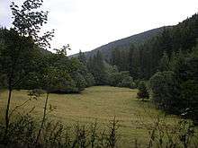
Ilmenau is located within a basin, formed by Ilm river on the northern edge of the Thuringian Forest at an altitude of 500 m of elevation. The surrounding mountains are the Pörlitzer Höhe (573 m) in the north, the Ehrenberg (528 m) and the Tragberg (534 m) in the east, the Lindenberg (749 m) in the south, the Kickelhahn (861 m) in the south-west and the Hangeberg (701 m) in the west. Whereas the first three belong to the foothills, the last ones are part of the mountainous Thuringian Forest. There is also a geological border between them: the mountain range is of porphyry and the foothills are of Muschelkalk (in the west) and Buntsandstein (in the east). The Kickelhahn is one of the most visited mountains within the Thuringian Forest and hosts and old viewing tower with a panorama above the town and the forest landscape.
The Ilm river has two considerable tributaries within the towns area: the Gabelbach is a small creek with a little valley between Kickelhahn and Lindenberg south of the city. It is one of the most preferred areas for walks next to Ilmenau. The other one is the Schorte, a bigger creek within a deep, 10 km (6 mi) long valley in the south-east, marked by many abandoned mining tunnels, among whom one can be visited as a mining museum. The area north of Pörlitzer Höhe ins't part of the Ilm's drainage basin, the emanating rivers here (Reichenbach near Roda district and Wipfra near Oberpörlitz district) are tributaries of Gera river, which is itself a tributary of Unstrut river.
An inner-city water area is the Ilmenauer Teichgebiet between the old town and the main campus of the university with 5 lakes, laid out by monks during the Middle Ages for breeding fish. The biggest lake with an area of 95 hectares is made up of the Wipfra river next to Heyda district by the Heyda Dam, built in the 1980s. Nearly the complete unbuilt on municipal area is covered by forest with spruces and pines (in the north) as main species. Smaller areas are also vegetated by beeches. The forest monocultures of spruces were caused by the enormous need of wood for mining and glass industry during the last centuries. However, they are susceptible to diseases and windthrow and shall be replaced by more natural mixed forests during the next decades after storm Kyrill led to enormous damage within the town's forests in 2007.
Administrative division
Ilmenau abuts the following municipalities, which are all part of the Ilm district: Neusiß, Plaue and Wipfratal in the north, Wolfsberg and Langewiesen in the east, Stützerbach, Schmiedefeld am Rennsteig and Gehlberg in the south as well as Elgersburg and Martinroda in the west.
There are five villages being incorporated as municipal districts of Ilmenau: Heyda (incorporated in 1994), Manebach (1994), Oberpörlitz (1993), Roda (1939) and Unterpörlitz (1981). A new municipal reform is discussed in Thuringia, where the city administration favours a union with the neighbour town Langewiesen.
Demographics

| Ten largest groups of foreign residents[8] | |
| Country of Origin | Population (2012-12-31) |
|---|---|
| 191 | |
| 127 | |
| 98 | |
| 83 | |
| 71 | |
| 57 | |
| 56 | |
| 45 | |
| 39 | |
| 38 | |
During the centuries, Ilmenau had been a small town of less than 2,000 inhabitants. The population grow began in the 19th century with an amount of 2,000 in 1800, 2,800 in 1850 and 3,400 in 1870. Then, a demographic boom occurred with a population of 10,400 in 1900 and 17,300 in 1940. After the World War II, the population rose further to 20,000 in 1975 and to the peak in 1988 with a population of 29,500. The bad economic situation in eastern Germany after the reunification resulted in a decline in population, which fell to 27,000 in 2000 before being relatively constant.
The average decline of population between 2009 and 2012 was approximately -0.03% p. a, whereas the population in bordering rural regions is shrinking with accelerating tendency. Suburbanization played only a small role in Ilmenau. It occurred after the reunification for a short time in the 1990s, but most of the suburban areas were situated within the administrative city borders (e. g. Oberpörlitz and Hüttenholz settlement), others were Langewiesen or Elgersburg.
The birth deficit was 132 in 2012, this is -5.1 per 1,000 inhabitants (Thuringian average: -4.5; national average: -2.4). The net migration rate was +2.8 per 1,000 inhabitants in 2012 (Thuringian average: -0.8; national average: +4.6).[9] The most important regions of origin of Ilmenau migrants are rural areas of Thuringia as well as foreign countries.
Like other eastern German cities, Ilmenau has only a small amount of foreign population: circa 4.4% are non-Germans by citizenship and overall 9.5% are migrants (according to 2011 EU census). Differing from the national average, the biggest groups of migrants in Ilmenau are Chinese, Russians and Syrians. During recent years, the economic situation of the city improved: the unemployment rate within the Ilm district declined from 21% in 2005 to 7% in 2013. Due to the official atheism in former GDR, most of the population is non-religious. 17.4% are members of the Evangelical Church in Central Germany and 5.0% are Catholics (according to 2011 EU census).
Culture, sights and cityscape
Museums
There are some museums in Ilmenau:
- The Goethe-Stadt-Museum within the Amtshaus at Marktplatz is both the municipal and a museum about Johann Wolfgang von Goethe and his connection to the city.
- The Jagdhaus Gabelbach in the forest south of the city is a former hunting lodge, built in 1783 showing an exhibition about hunting and forestry during the 18th century.
- The Fischerhütte at Langewiesener Straße is a former glass factory and shows historic laboratory glassware, produced in Ilmenau as well as temporary exhibitions, for example about optics and light.
 Goethe-Stadt-Museum
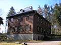 Jagdhaus Gabelbach
 Fischerhütte
Cityscape
The town fire in 1752 destroyed nearly all the buildings in Ilmenau, so that the town was rebuilt during the 1750s and 1760s in a relatively uniform late-Baroque style by Gottfried Heinrich Krohne. The town centre is located between Obertorstraße in the north, Poststraße in the east, Mühlgraben in the south and Burggasse in the west and two old suburbiums are the quarters around Rasen in the north-west and Lindenstraße in the south-west. Between 1871 and 1914, some interesting mansion districts developed: a bigger one in the south-west around Waldstraße and Goetheallee and a smaller one in the west around Sturmheide, which are hosting noble mansions in Gründerzeit and Art Nouveau style. On the one hand, the rich factory owners lived here and on the other hand, many buildings were in use as guesthouses as Ilmenau was a spa during the 19th century. During the GDR period, two big Plattenbau settlements were established in the south-east ("Stollen") and in the north ("Pörlitzer Höhe"). The university's main campus at Ehrenberg in the east were set up in the 1950s and enlarged during the following decades until today. It hosts also some interesting architecture from the Stalinist neo-classicism to contemporary glass-and-steel architecture.
 Pedestrian area in the centre
 The Lindenstraße, Ilmenau's boulevard
 Historistic mansion at Waldstraße
 Art Nouveau mansion at Waldstraße
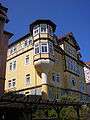 Mansion at Sturmheide
 Plattenbau settlement at Pörlitzer Höhe
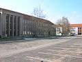 Neo-classicist Helmholtzbau at Ehrenberg campus
Sights and architectural heritage
Older buildings (pre-1870)
- The St. James' Church at Marktstraße is the evangelical main church of Ilmenau, built after the town fire of 1752 in late-Baroque style.
- The Holy Cross Church at the cemetery north of the city centre is a small church, built in 1852. Furthermore, the historic cemetery hosts some 18th-century graves and a mourning hall (now reused as a Columbarium), built in 1836 in classicistic style.
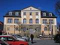
- The town hall at the Marktplatz was also built after the last town fire of 1752.
- The Zechenhaus is one of the oldest buildings in Ilmenau, built in 1730. It was in use as seat of the local mining authority.
- The Bergmannskapelle (17th century) is a small wooden chapel, former used by the miners to pray for good luck.
- The Alte Münze (1691) at Wallgraben was the mint, where the Ilmenau Talers were coined around 1700.
- The parsonage at Kirchplatz was built in the 1760s in Baroque style.
- The Alte Försterei (1733) at Wetzlarer Platz is a small Baroque forester's lodge.
- The Wasserburg at Amtsstraße is a castle ruin, consisting of only few low walls.
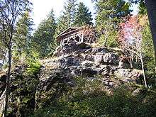
- The Kickelhahnturm (1855) and the Goethehäuschen (1783) are built on the top of the Kickelhahn mountain south of the town.
 St. James' Church
 Holy Cross Church
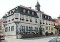 Town hall
 Bergmannskapelle
 Alte Försterei
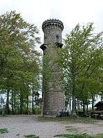 Kickelhahnturm
 Goethehäuschen at Kickelhahn
Modern architecture (after 1870)
- The Neues Technikum at Weimarer Straße was built in 1926 for enlarging the university's predecessor in modern style.
- A department store at Friedrich-Hofmann-Straße, built in 1928 has a Bauhaus-style glass façade.
- A house at Naumannstraße was built from 1929 to 1932 in international-modern Bauhaus-style by Arthur Schröder.
- The St. Joseph's Church at Unterpörlitzer Straße was built between 1979 and 1983 as catholic parish church in modern style.
- The Goethe memorial at the Marktplatz was established in 1996.
- The new Audimax of the university was built during the 2000s in modern style, same as a new auditorium's building in form of a glass cube at Weimarer Straße.
- The Bundesanstalt für Wasserbau, a federal authority based in Ilmenau, was built around 2000 in boomerang-style.
 Neues Technikum
 Department store in Bauhaus-style
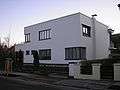 Bauhaus-style house at Naumannstraße
 St. Joseph's Church
 Goethe memorial
 University's new Audimax
 Bundesanstalt für Wasserbau
Economy


Agriculture plays no role in Ilmenau, only 18% of the municipal territory are in agricultural use. The soil isn't very fertile and the climate is harsh, the most cultivated strains are maize and rapeseed, furthermore there is cattle farming on some areas. On the other hand, 64% of the territory are forest, so that wood production plays a role in Ilmenau.
The industry was based on the production of glassware and porcelain during the 19th and 20th century with many large and famous companies (porcelain brands: Henneberg (est. 1777), Metzler & Ortloff (est. 1873)). The porcelain industry didn't survive the structural change after the German reunification in 1990, so that the factories got closed like the most ones in Western Germany already during the 1970s and 1980s. The glass industry was always focussed on laboratory glassware like thermometers, test tubes and other chemical and medical uses. During the GDR period, all the glass factories of Ilmenau and the surrounding villages were centralized in a new Kombinat, opened in 1976 with 5,000 workers in Ilmenau being one of the biggest glass producers within the Comecon. After the reunification, the factory survived and is still a leading company for laboratory glassware in Germany, nevertheless, due to rationalization efforts during the 1990s, the number of employees decreased to 225. After 1990, new branches established in Ilmenau, especially mechanical engineering and polymer processing are playing an important role in Ilmenau, same as software engineering. These new branches benefit from the vicinity to the university and the research institutes. In 2012, there were 26 companies in industrial production with more than 20 workers employing 1,500 persons and generating a turnover of €170 millions.[10]
Services including the typical regional supply (like retail, hospital, cinema etc.) and an emphasis on the university (which is the biggest employer with 2,000 employees), research and industrial services. Tourism plays also a role since the town became a spa in the 1830s. In 2012, there were 49,000 hotel guests having 114,000 overnight stays in Ilmenau.[11]
Transport
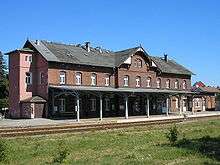
Ilmenau is connected to the Ilmenau-Erfurt railway since 1879 with hourly service to Erfurt via Arnstadt and stations in the city centre and in the districts of Pörlitzer Höhe and Roda. Another line to Großbreitenbach was opened in 1881 and closed in 1998 and a third one to Themar via Schleusingen opened in 1904. Since 1998, there is no regular service anymore, but there are some historical steam locomotives running at special events on that railway, which is crossing the Thuringian Forest on one of the steepest lines in Germany (with a gradient of 6%). Freight transport by rail plays no role anymore, with exception of a train transporting the town's garbage to the incinerator of Leuna.
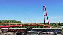
Ilmenau is situated at the Bundesautobahn 71 to Erfurt in the north and Würzburg/Nuremberg (via A 73) to the south. Next to the town, this Autobahn crosses the Thuringian Forest with some of Germany's largest tunnels and bridges. Furthermore, there were three Bundesstraßen connecting Ilmenau: the Bundesstraße 4 to Erfurt in the north and Coburg in the south (annulled after the opening of A 71 during the 2000s), the Bundesstraße 87 to Weimar in the north-east (now starting at the Autobahn some kilometers north-east of the town) and the Bundesstraße 88 to Eisenach in the north-west and Rudolstadt in the east, which was relocated around Ilmenau as a bypass road (via the A 71 in the north and on a new line in the east).
The next local airport to Ilmenau is the Erfurt–Weimar Airport, approx. 40 km (25 mi) to the north, which serves mostly for holiday flights to the Mediterranean and other turistic regions. The next major airports are Frankfurt Airport, the upcoming Berlin Brandenburg Airport and Munich Airport.
Biking is getting more and more popular since the construction of quality cycle tracks began in the 1990s. For tourism serve the Ilm track from the Rennsteig within the Thuringian Forest to the Saale valley at the Saxony-Anhalt border via Ilmenau and Weimar. Furthermore, there are cycle track connections to the near Gera track (in Elgersburg) to Erfurt and to the Saale valley in the east via Gehren, Königsee and Rudolstadt. Many ways through the forest are in use by mountain bikers, which is very popular in the region. There are only few cycle lanes for inner city every-day traffic but using side roads and paths is working well. Despite the hilly terrain in some parts, Ilmenau is a biking city, due in part to the high percentage of residents being students.
Public transport is carried out by a bus line network connecting the city centre with the outskirts and neighbouring villages.
Education and research

The Technische Universität Ilmenau has 7,000 students and is Thuringia's second-largest university, founded in 1894 as Thüringisches Technikum, converted to a university in 1992. Its emphasis is on mathematics, physics, informatics, several engineering disciplines and media studies. Furthermore, there are two Gymnasiums in Ilmenau, one offers a focus in sciences as an elite boarding school in addition to the common curriculum. They are called Gymnasium "Am Lindenberg"[12] - which focuses on languages and economics, and Goetheschule[13] which specialises in science and mathematics.
Notable research institutes are:
- Fraunhofer Institute for Digital Media Technology
- Fraunhofer Institute of Optronics, System Technologies and Image Exploitation
- Institut für Mikroelektronik- und Mechatronik-Systeme
Politics
Mayor and city council
The current mayor Gerd-Michael Seeber, CDU is in office since 1990.
The last municipal election was held in 2009 with the result:
| Party | Percentage | Seats in council |
|---|---|---|
| CDU (conservative) | 39.4 | 12 |
| The Left (post-socialistic left) | 19.5 | 6 |
| SPD (social democratic) | 10.6 | 3 |
| Free Voters (citizen-oriented/populist) | 10.5 | 3 |
| Bürgerbündnis (green) | 9.5 | 3 |
| Pro Bockwurst (studental/pirate) | 6.4 | 2 |
| FDP (classical liberal) | 4.1 | 1 |
Twin towns
Ilmenau is twinned with:
Notable persons
- Jan Behrendt, (born 1967), luger, born in Ilmenau
- Robert Döpel, (1895-1982), nuclear physicist, died in Ilmenau
- Wolfram Fiedler, (1951-1988), luger, born in Ilmenau
- Marie Gutheil-Schoder, (1874-1935), soprano, died in Ilmenau
- Andrea Henkel, (born 1977), biathlete born in Ilmenau
- Karl Ludwig von Knebel, poet, retired to Ilmenau
- Stefan Krauße, luger, born in Ilmenau
- André Lange, bobsledder, born in Ilmenau
- Andreas Libavius, (1555-1616), philosopher and chemist, taught in Ilmenau
- Paul Löbe, (1875-1963), politician, (SPD), worked as a printer in Ilmenau
- Jens Müller, luger, lives in Ilmenau
- Ute Oberhoffner, luger, born in Ilmenau
- Matthias Platzeck, (born 1953), politician (SPD), studied and graduated in Ilmenau
- Fritz Reinhardt, Nazi Finance Minister, born in Ilmenau
- Fritz Sauckel, (1894-1946), Nazi war criminal, studied in Ilmenau
- Corona Schröter, singer, died in Ilmenau
- Peter Sendel, biathlete, born in Ilmenau
- Johann Karl Wilhelm Voigt, (1752-1821), mineralogist, worked and died in Ilmenau
More notable people
- Claudia Nolte (born 1966), politician (CDU), 1994-1998 Federal Minister for family affairs, studied in Ilmenau
- Hartwig Gauder (born 1954), walker, moved in 1960 to Ilmenau, later to Erfurt, Olympic champion in the 50-km walk in 1980
- Friedrich Christoph Pelizaeus (1859-1942), neurologist, temporarily spa doctor in Ilmenau
- Theodor Eicke (1892-1943), high-ranking SS officer, studied 1918-1919 in Ilmenau without receiving a degree
References
- ↑ "Bevölkerung der Gemeinden, Gemeinschaftsfreie Gemeinde, erfüllende/beauftragende Gemeinden, Verwaltungsgemeinschaft/Mitgliedsgemeinden in Thüringen". Thüringer Landesamt für Statistik (in German). July 2016.
- ↑ The poem Ilmenau on Wikisource
- ↑ Sutro (M.D.), Sigismund (1865). Lectures on the German Mineral Waters, and on their rational employment. With appendix on principal European spas and climatic health-resorts (2nd ed.). London: Longmans, Green & Co. p. 340. Retrieved 13 December 2009. Cites doctors practicing at Ilmenau's hydropathic establishment.
- ↑ Abdy, E.S. (1842). "The Water Cure: Cases of disease cured by cold water". translated from the German. London: Charles Gilpin. Retrieved 13 December 2009. Ilmenau mentioned several places, but see p.vi for reference to Dr Fitzler.
- ↑ "Bergbaurevier um Ilmenau - Historischer Abriss (Mining area, at Ilmenau - Historical overview)", City of Langewiesen website (translations via Google), Bergwerk page last updated 08.09.2009, retrieved 13 December 2009 Check date values in:
|date=(help) - ↑ Hubert, Firma D (Last updated May 2008), "Geologie: Die Flouritlagerstätten des Ilmenau-Gehrener Reviers (Geology: The Flouritlagerstätten of Ilmenau-Gehrener coalfield)", Der Bergbau und die Interessengemeinschaft zur Erhaltung alter Bergmannstraditionen in Ilmenau, retrieved 13 December 2009 Check date values in:
|date=(help) Translations via Google. - ↑ Atlas of Minerals website
- ↑ Ausländerstatistik 31.12.2012
- ↑ According to Thüringer Landesamt für Statistik
- ↑ According to the Thüringer Landesamt für Statistik
- ↑ According to Thüringer Landesamt für Statistik
- ↑ http://www.gym-amlindenberg.de/
- ↑ http://www.goetheschule-ilmenau.de/
External links
| Wikimedia Commons has media related to Ilmenau. |
- Official website (English) (German)
 |
Eisenach — Gotha | Erfurt Arnstadt |
Weimar — Jena | |
| Schmalkalden | |
Rudolstadt Saalfeld | ||
| ||||
| | ||||
| Meiningen — Suhl | Coburg Bamberg |
Sonneberg |