Illinois Route 8
| ||||
|---|---|---|---|---|
| Route information | ||||
| Maintained by IDOT | ||||
| Length: | 45.51 mi[1] (73.24 km) | |||
| Existed: | November 5, 1918[2] – present | |||
| Major junctions | ||||
| West end: |
| |||
|
| ||||
| East end: |
| |||
| Location | ||||
| Counties: | Knox, Peoria, Tazewell | |||
| Highway system | ||||
| ||||

Illinois Route 8 is an east–west state road in central Illinois. It runs east from Illinois Route 97 south of Maquon to the intersection of U.S. Route 24 (McClugage Avenue) and Business U.S. 24 near Washington. Illinois 8 is 45.51 miles (73.24 km) long.[1]
Route description
Illinois 8 largely parallels Interstate 74 from Maquon to Washington. After entering Peoria from the west, it crosses the Illinois River with Illinois Route 29 and Illinois Route 116 on the Cedar Street Bridge between Peoria and East Peoria. Illinois 8/29/116 stays joined until Main Street, where Illinois 29 continues southbound to Pekin while Illinois 8/116 travel northbound, albeit briefly, towards I-74.
At Camp Street, Illinois 116 continues geographically northeast, and is signed east, with U.S. Route 150 westbound, forming a wrong-way concurrency. Illinois 8 turns east onto Camp Street with U.S. 150 eastbound. In spite of this concurrency, as of 2005 the eastbound I-74 exit to Camp Street was only marked for U.S. 150, while the next eastbound exit to Washington Street was marked as "To Illinois 8" even though Washington Street is unnumbered in East Peoria. Past the Camp Street/Washington Street intersection, U.S. 150 leaves Illinois 8 and runs east-southeast towards Morton, while Illinois 8 runs east-northeast through unincorporated Sunnyland.
Near Washington, Illinois 8 turns westbound onto Business U.S. 24 (despite being signed as East Illinois 8) to terminate at U.S. 24.
History
SBI Route 8 ran from Gulfport on U.S. Route 34 at the Iowa state line to Sheldon on U.S. Route 24 at the Indiana state line. It was truncated in 1965, with some of its segments moving to its modern alignment from Illinois Routes 78 and 116[2]
Major intersections
| County | Location | mi | km | Destinations | Notes |
|---|---|---|---|---|---|
| Knox | | ||||
| | West end of IL 78 overlap | ||||
| Peoria | Elmwood | East end of IL 78 overlap | |||
| Peoria | West end of IL 116 overlap | ||||
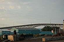
| Illinois River | Cedar Street Bridge | ||||
| Tazewell | East Peoria | Edmund Street | Interchange | ||
| Interchange; west end of US 24 overlap / IL 29 overlap | |||||
| East end of US 24 / IL 29 / IL 116 overlap; west end of US 150 overlap | |||||
| Westbound exit and eastbound entrance | |||||
| East end of US 150 overlap | |||||
| Washington | West end of US 24 Bus. overlap | ||||
| | East end of US 24 Bus. overlap | ||||
1.000 mi = 1.609 km; 1.000 km = 0.621 mi
| |||||
See also
References
- 1 2 Illinois Technology Transfer Center (2007). "T2 GIS Data". Retrieved 2007-11-08.
- 1 2 Carlson, Rick. Illinois Highways Page: Routes 1 thru 20. Last updated March 15, 2006. Retrieved March 24, 2006.