Illinois Caverns State Natural Area
| Illinois Caverns State Natural Area | |
|---|---|
|
IUCN category Ib (wilderness area) | |
 Map of the U.S. state of Illinois showing the location of Illinois Caverns State Natural Area | |
| Location | Monroe County, Illinois, USA |
| Nearest city | Waterloo, Illinois |
| Coordinates | 38°14′08″N 90°08′13″W / 38.23556°N 90.13694°WCoordinates: 38°14′08″N 90°08′13″W / 38.23556°N 90.13694°W |
| Area | 120 acres (49 ha) |
| Established | April 23, 1901 |
| Governing body | Illinois Department of Natural Resources |
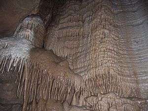
Illinois Caverns is a state natural area in the New Design Precinct of Monroe County, Illinois. It features Illinois Caverns which is alternatively known as Mammoth Cave of Illinois (also Burksville Cave, Egyptian Cave, Eckert Cave). Illinois Caverns is the second-largest cave in Illinois and has more than 9.6 km of passages.[1] The cave has a constant temperature of 58 °F (14 °C), and portions flood during wet weather. Passages can be 20 feet (6.1 m) high and just as wide. It is located off Illinois Route 3, south of Waterloo, near the unincorporated community of Burksville.
History
What is now known as Illinois Caverns hosted its first paying customers in March 1901, operated by a Mr. White of East Saint Louis. It is the only cave in Illinois to have been commercially operated, attracting many visitors from St. Louis during the 1904 World's Fair. However the cave was never considered a commercial success (it closed in 1907), and had remained almost completely unimproved, excepting the extant concrete entrance stairs and a single ladder. When the cave and environs were sold to the State of Illinois in 1985, care of the site was entrusted to Armin Krueger, until his death.
Geology
The cave was, and in fact still is being formed in the Mississippian limestone (CaCO3) and dolomite (CaMg(CO3)2) (or karst common to the region) by water dissolution, and includes cave formations such as stalactites, stalagmites, rimstone dams, flowstone, and soda straws. The cavern is a branchwork type cave, which generally consists of a central cavern and stream with smaller passages and tributaries branching off. Numerous circular, crater-like depressions are evident in the area surrounding the entrance, easily visible from the air or space.[2] These are typical of both the area and karst topography in general
Cave Fauna
Fauna in the cave includes bats, salamanders, frogs, crickets, amphipods, and isopods. Illinois Caverns is home to the federal endangered species Gammarus acherondytes (a.k.a. Illinois Cave Amphipod). This species of amphipod is found nowhere else in the world except a few neighboring caves located in the southwestern Illinois karst.
Visitation
The cave has been closed for visitors since early 2010 to stop the spread of White Nose Syndrome (WNS) in bats.
Persons desiring to enter the cave need a permit; see official web site below for more information. A minimum of four people per party is needed for entrance into the cave. Each person needs to have a hardhat, boots, sturdy clothing, and three sources of light. At times some portions of the cave may be off-limits, these areas should be clearly marked.
To reach Illinois Caverns from the north, take Route 3 south past Waterloo about two miles, make a right on Kaskaskia Road. In Burksville, make a left onto KK Road heading east, then a right on G Road, the entrance is on the right, about two and a quarter miles south of KK Road.
From Red Bud, take Route 3 north for about five miles and make a left onto II Road. Bearing left at Sportsmans Road, proceeding through Tipton and bearing right at the Y intersection with R Road, to remain on II Road for about five miles, until it crosses G Road. Make a right and the entrance will be on the left, less than a mile north of II Road.
External links
- Illinois Caverns - State Natural Area
- Illinois Caverns Grotto Map - Rock River Speleological Society
- Illinois Caverns Closure Notice
References
- ↑ Panno, S.V.; S.E. Greenberg; C.P. Weibel; P.K. Gillespie (2003). A Guide to the Illinois Caverns State Natural Area. Illinois State Geological Survey GeoScience Education Series. p. 66.
- ↑ "satellite view, Google Maps"
| Counties | 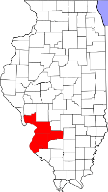 | |
|---|---|---|
| Major Cities (25,000+) | ||
| Cities (5,000-25,000) | ||
| Villages and Towns (1,000-5,000) |
| |
| Interstates in the Metro-East | ||
| Airports/Military Bases | ||
| List of Colleges in the Metro-East | ||
| Sports teams based in the Metro East |
| |