Iliamna Airport
Iliamna Airport (IATA: ILI, ICAO: PAIL, FAA LID: ILI)[2] is a state-owned public-use airport located three nautical miles (5.5 km) west of the central business district of Iliamna, in the Lake and Peninsula Borough of the U.S. state of Alaska.[1]
Facilities and aircraft
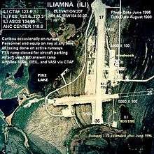
Iliamna Airport has two asphalt paved runways: 7/25 is 5,087 by 100 feet (1,551 x 30 m) and 17/35 is 4,800 by 100 feet (1,463 x 30 m). It also has two seaplane landing areas: Runway E/W measures 2,998 x 400 ft. (914 x 122 m) and Runway N/S measures 2,892 x 400 ft. (881 x 122 m).[1]
For the 12-month period ending December 31, 2004, the airport had 15,400 aircraft operations, an average of 42 per day: 73% general aviation and 27% air taxi. There are 18 aircraft based at this airport: 89% single engine and 11% multi-engine.[1]
Airlines and destinations
References
- 1 2 3 4 FAA Airport Master Record for ILI (Form 5010 PDF), effective 2007-07-05
- ↑ Great Circle Mapper: ILI - Iliamna, Alaska
- ↑ Iliamna Air Taxi
External links