Igbo Eze South
| Igbo Eze South Igboeze South | |
|---|---|
| LGA | |
 Igbo Eze South Location in Nigeria | |
| Coordinates: 6°55′N 7°24′E / 6.917°N 7.400°ECoordinates: 6°55′N 7°24′E / 6.917°N 7.400°E | |
| Country |
|
| State | Enugu State |
| Area | |
| • Total | 158 km2 (61 sq mi) |
| Population (2006 census) | |
| • Total | 147,328 |
| Time zone | WAT (UTC+1) |
| 3-digit postal code prefix | 413 |
| ISO 3166 code | NG.EN.IS |
Igbo Eze South (or Igboeze South) is a Local Government Area of Enugu State, Nigeria. Its headquarters are in the town of Ibagwa-Aka (or Ibagwa-Eka).
It has an area of 158 km² and a population of 147,328 at the 2006 census. Ten towns make up Igbo-eze south Local. These are Eror Agu, Unadu, Itchi, Nkalagu-Obukpa, Ibagwa Aka, Iheakpu -Awka, Uhunowerre, Ovoko-Ulo, Ovoko-Agu Iheaka. Agriculture and trade are the mains economic activities. Agro produce like Yams, Palm oil, Cassava, Bambara Nuts, Palm Kernel, Cowpea, and Livestock are produced and traded at the market.
There are major Markets in Igbo-eze south, these include Orie Igbo-eze, Nkwo Ibagwa, Ahor Unadu, Eke itchi. These market mostly operate on a rotational basis representing the Four market days of traditional Igbo Calendar-Eke, Orie, Ahor, Nkwo
Climate
The rainy season begins in March/April and lasts until October/November[8] with annual rainfall varying from 1,400mm to 2,000mm
An average annual temperature above 20 °C (68.0 °F) creates an annual relative humidity of 75%. With humidity reaching 90% in the rainy season. The dry season experiences two months of Harmattan from late December to late February. The hottest months are between January and March.
The postal code of the area is 413.[1]
References
- ↑ "Post Offices- with map of LGA". NIPOST. Retrieved 2009-10-20.
State capital: Enugu | ||
| LGAs | 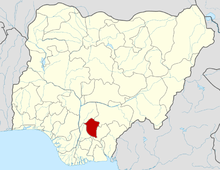 | |