Akyaka, Muğla
| Akyaka | |
|---|---|
|
Arch. Nail Çakırhan own house in Akyaka, recipient of 1983 Aga Khan Award for Architecture | |
 Location of Akyaka, Muğla within Turkey. | |
 Akyaka Location of Akyaka, Muğla within Turkey. | |
| Coordinates: 37°03′N 28°19′E / 37.050°N 28.317°ECoordinates: 37°03′N 28°19′E / 37.050°N 28.317°E | |
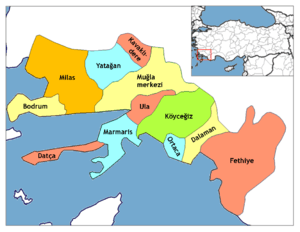
| Country |
|
| Region | Aegean |
| Province | Muğla |
| Time zone | EET (UTC+2) |
| • Summer (DST) | EEST (UTC+3) |
| Postal code | 48x xx |
| Area code(s) | (0090)+ 252 |
| Licence plate | 48 |
| Website | www.akyaka.bel.tr |


Akyaka is a coastal township with its own municipality in the Ula district of Muğla Province in southwestern Turkey. The town is situated at the far end of the Gulf of Gökova, at the start of the fertile Gökova plain, and is a rising center for international tourism due to its advantageous location and natural beauties. It is the first coastal town encountered on the busy road from the province center of Muğla to the better known resort center of Marmaris, and it comes into sight, along with a spectacular view of the gulf and the plain, some thirty miles after departure from Muğla at Sakar Pass, a favorite paragliders' spot where the road descends from an altitude of 670 m. to sea-level in the space of a pine-clad section of a dozen kilometers along very sharp curves. At the base of the hill is the intersection to Akyaka.
Locally and casually, erroneously and confusingly, the township of Akyaka is sometimes referred to as Gökova, after the name of the gulf and the plain, while there is also an inland township of Gökova neighbouring Akyaka, itself of visitor's interest and whose intersection is slightly further ahead from that of Akyaka in the direction of Marmaris.
History
Much of the Gökova plain had been unproductive for centuries, until the later half of the 20th century, and was covered with marshlands ridden with malaria. The inhabitants abandoned their settlements and fields entirely during the months of active malaria and moved to highland plateaus (yayla). The arable land available was usually owned by large landowners from the district center of Ula. An organized program to combat malaria, one of the priorities of the young Turkish Republic of the 1920s, was enacted under a specific law in 1926, in the frame of which ownership titles were awarded to individuals or groups of people on the basis of the swampland they drained, and were quite successful in the transformation of Akyaka region, especially through the local projects lasting from 1925 to 1940. In the following decades, conversion of fields for cash crops, particularly tobacco, dominated the local economy and this until the 1970s when the first steps in the tourism industry were taken. Akyaka became quite cosmopolitan in recent years.
Idyma
Safe altitude considerations governed the choice for settlements of the ancients as well. Gökova town, inland from Akyaka was the location of the historic city of Idyma, some of whose remains reaching back at least to the 4th century BC, when it was founded as a Carian city, are still visible. Idyma urban zone may have extended as large as the area between the immediate east of Akyaka well beyond the village of Kozlukuyu, a dependent neighborhood of the town of Gökova, 3 km away. The acropolis, city walls 200 meters in length and around fifty rock tombs are located along the steep climb (sea level to 400 meters) of Kucuk Sakar at Kozlukuyu. The Acropolis was explored by the French archaeologist Louis Robert in 1937.
In 546 BC, the Persian armies under the command of Harpagos conquered the area, but the Carian customs and the religion remained unchanged. Delian League took over between 484 and 405 BC and Idyma is mentioned in the tax lists for the years 453-452 BC, the earliest written document on the city. The same reports mention a local sovereign by the name of Paktyes, whose descendants may have founded a dynasty which governed Idyma and to whose members the rock tombs could be attributable.[1] A mint city, Idyma produced its own coins, one side of which was marked with the name Idimion, and the other side with the head of a Pan, hinting at a shepherd's cult.[2]
From 167 BC to at least the 2nd century AD, Idyma, together with the entire region south of Muğla (Mobolla) was part of the Rhodes's mainland possessions (Peræa Rhodiorum). A Byzantine castle worth restoring also stands on the slopes of Sakar and an underground tunnel leads to the bank of the stream of Azmakdere or Kadın Azmak, possibly named Idymus in ancient times.
Because of the extent of the ancient site, in terms both of its area and longevity, some of its archaeological finds are associated with Akyaka, while many with Gökova and particularly Kozlukuyu.[3]
Azmak Stream
Azmak is the name in short of a short but deep stream which joins the sea in Akyaka and formed by springs extending about two miles from East to West. Its depth allows boats to ascend it for a considerable distance and the richness of its underwater fauna made it a favorite spot for daily boat tours around Akyaka and for scuba diving. The water is cold and slightly salty due its level course with the sea across the plain, but watercress and celery thrive in Azmak and restaurants along its course make the stream a symbol and an important point of attraction for Akyaka region.[4]
The word "azmak", sometimes used to describe a river, means "running wild" in Turkish, in a reference to the stream's strong, rather than violent, current, especially in winter. Akyaka's azmak is also referred to under the fuller name of "Kadın Azmak", qualifying it with female attributes and distinguishing it from azmak of Akçapınar at the opposite side of the same plain, or from namesakes in Gallipoli Peninsula or Bulgaria.
Architecture
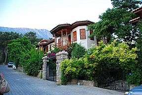
Akyaka district is featured with its architectural structure and applies a uniform construction regulation. Thus, the district has formed a distinct building structure exclusive to Akyaka by combining the style of former Ula houses, an old town near the provincial capital of Muğla, which provided the inspiration for the architecture of Akyaka, with modern architecture style. These flowery gardened double stair houses were designed with lovely wooden balconies and overhanging roofs in a way that makes them look both modern and historic at the same time. The ceiling decorations are spectacular at Akyaka, famous for its authentic houses.
This unique combined architectural style of Akyaka houses were created by Nail Çakırhan who had built a winning house blended modern development with natural beauty, inspiring other developers to build in sympathy with an idyllic location where the Kadin Azmak and Akcapinar Azmak streams run down to the sea.
See also
- Nail Çakırhan
- Gulf of Gökova
- Gökova Town, Muğla, Turkey
- Turkish Riviera
- Blue Cruise
- Foreign purchases of real estate in Turkey
References
- ↑ A Manites, son of Paktyes, is recorded as having attempted on Mausolus's life in 355 BC.
- ↑ Wayne G. Sales (2007). Ancient Coin Collecting II ISBN 0-89689-516-5 p. 91. Krause Publications.
- ↑ Alain Bresson (1991). Recueil des inscriptions de la Pérée Rhodienne 978-2-251-60445-9 p. 181-182 (in French). University of Franche-Comté.
- ↑ Vincenzo Ruggieri, Franco Giordano (2003). Il golfo di Keramos ISBN 88-498-0414-8 p.50 (in Italian). Rubbettino Editore srl.
Sources
| Wikivoyage has a travel guide for Akyaka. |
| Wikimedia Commons has media related to Akyaka. |
- Peter Benedict (1974). Ula : An Anatolian Town ISBN 90-04-03882-5. Brill Publishers.
- George E. Bean (1971). Turkey beyond the Maeander ISBN 0-87471-038-3. Frederick A. Praeger, London.