Ideato South
| Ideato South LGA | |
|---|---|
| LGA | |
 Ideato South LGA Location in Nigeria | |
| Coordinates: 5°51′N 7°6′E / 5.850°N 7.100°ECoordinates: 5°51′N 7°6′E / 5.850°N 7.100°E | |
| Country |
|
| State | Imo State |
| Area | |
| • Total | 88 km2 (34 sq mi) |
| Population (2006 census) | |
| • Total | 159,879 |
| Time zone | WAT (UTC+1) |
| 3-digit postal code prefix | 475 |
Ideato South is a Local Government Area of Imo State, Nigeria.[1] Its headquarters are in the town of Dikenafai, the source of Orashi River.[2][3][4] Ideato South has an area of 88 km² and a population of 159,879 at the 2006 census.[5] [6][7] The postal code of the area is 475.[8]
Autonomous Community
There are twenty-three (23) autonomous communities in Ideato-South LGA. These are Nneato Ogwugwu, Isiekenesi, Dikenafai, Dimagu, Okohia and Umuaghobe autonomous communities. Others are Awalla, Umuakam, Umuago, Umuobom Umuezedike Duruahurunwa, Umuchoke, Umumaisiaku, Amanator, Umueshi, Ntueke, Obioha, Umuchima, Ugbelle, Umulewe and Ogwume, Umuezealla-Ogboko and Ogboko autonomous community[5]
Water
Orashi River takes off from Ezeama community in Dikenafai.[2][6][9] Described as a lifeline to Ideato South communities, Orashi stream serves as an all purpose river for drinking, washing and many other purposes to communities such as Umulewe, Umuezealla-Ogboko, Umuchima and Ntueke.[10]
Erosion
Ideato South, like many other areas of Orlu senatorial zone, has faced erosion problems such as Umueshi, Umuezealla-Ogboko gully erosion site.[1][11][12][13]:2 An intervention programme was kicked-off. Umueshi Gully Erosion intervention site has Amanato and Ntueke as neighbouring (watershed contributor) communities.[11] Whilst appealing for support in September 2000, the chairman of the Local Government area, Chief Ethelbert Okwaranya said there were 26 erosion sites which claimed many lives and rendered thousands of people homeless.[14] Other communities in the area suffering this problem includes Umuojisi.[12]
Agriculture and Forestry
The Ideato-South depends mainly on agriculture and commerce and the main occupation of the people is farming and trading.[5] Most of their cash crops are taken to the market depending on the market that falls when they intend to sell their farm produce (Eke,Orie, Afo and Nkwo). Their cash crops include oil palm, raffia palm, groundnut, melon, cotton, cocoa, rubber, maize, etc. Food crops such as yam, cassava; cocoyam, breadfruit, and three-leaf yam are also produced in large quantities. The location of this L.G.A within the tropical rainforest gives it the ecological basis for production of a wide range of tropical agriculture crops with widespread potentialities for industrial convention.
Greater than the past decades the population density has led to intensified strain on land, forests and other natural resources, leading to escalating pastoral scarcity which is an attribute of thickly inhabited pastoral areas. Crop-free period seldom exceeds one year and in some areas constant cropping is the regulation. Little crop yield and pasting of land to erosion have pooled to tempt people to travel in search of jobs in other parts of the country.[5]
Seeing that as an approach for enhancing agricultural development, private depositors are invited to take part in direct agricultural production, by investing in the planting and cultivation of agricultural crops such as maize, rice, legumes, roots and tubers.
Costume
They are also known for their well-dressed traditional wear, like many other communities and cities across Igboland. The traditional attire for the men is an overflowing jumper or a long-sleeved shirt worn over the George wrapper, which is tied around the waist, curving down to the ankles. This dress is matched with a cap and a walking stick, which aids as an instrument of support and defense. The traditional wear for the women is a blouse, worn over a loin cloth. This female attire goes with a head-tie ear rings and necklaces or traditional necklaces. Arts and Craft: traditional artist thrive in this municipal rural communities. Works of art produced in the area comprises, carved doors, walking sticks of different designs, sculptures, flutes, wooden mortars and pestles, gongs, and the famous talking drums. Metal works and various types of productions are locally fashioned.
Culture
Part of the culture of the state in the Igbo traditional kindness to visitors, which begins with the offering of the kolanuts to the visitor, is enriched in the communities of Ideato-South. The kolanut is indicating that the visitor is very much welcomed. The ritual of the offering of kolanut is inspired with the giving in prayers and blessing or lobby to the supreme God and other deities, for the protection of the visitor and the host. This seems to be a custom to the people of this LGA in any traditional ceremony the presentation of African salad (Abacha). The Okonko festival of Umuezealla-Ogboko is very rich and unique. There are also several social titles which feature outstandingly throughout Ideato-South. The chieftaincy titles are very common and highly regarded. They include: Eze (king), Okenze, Nze, Ozo, Ichie, Durunze etc.
Beliefs
There is freedom of worship in Imo state, and Nigeria as a whole. Religion occupies a central place in the heart of the people. The people are mostly Christians of different denominations.
Ideato-South is becoming the intellectual and political Mecca of Igbo land and indeed Nigeria. Due to the fact that most of their sons and daughters have become engineers, doctors, administrators, barristers, accountants, information technologists etc. Many are based in Europe, North America, South America, Asia, and other parts of the world in search of knowledge and wealth.
References
- 1 2 Oyegun, Charles Uwadiae; et al. (2016). "Gully Characterization and Soil Properties in Selected Communities in Ideato South Lga, Imo State, Nigeria". Department of Geography and Environmental Management, University of Port Harcourt, Port Harcourt, Nigeria. Nature and Science. 14(2): 2. ISSN 2375-7167. Retrieved May 21, 2016.
- 1 2 "The source of Urashi River". tours.logbaby.com. Retrieved May 20, 2016.
- ↑ Ijeoma, Henry M; et al. (2008). "Urashi Waterfall Ecotourism Development and Cultural Challenges in Dikenafai, Ideato South Local Government Area, Nigeria". Department of Forestry and Wildlife Management, University of Port Harcourt, Port Harcourt, Rivers State. African Research Review: An International Multi-Disciplinary Journal, Ethiopia. 7: 4. ISSN 1119-023X. Retrieved May 20, 2016.
- ↑ Nema Obih (E.Obih-Frank) (2004). "My Father's Village – Excerpts from a Memoir in Progress (New York)" (PDF). www.oralhistory-productions.org. Retrieved May 21, 2016.
- 1 2 3 4 "Ideato South Local Government Area, IDSLGA: About Us". 2014. Retrieved May 21, 2016.
- 1 2 "IDEATO SOUTH UNION UK: History". Retrieved May 21, 2016.
- ↑ Ukoha, Henri; et al. (2015). "Analysis of Cassava Value Chain in Ideato South Local Government Area, Imo State, South-East Nigeria" (PDF). Department of Agricultural Economics, Federal University of Technology Owerri, Nigeria. International Journal of Life Sciences. 4 (4): 2. Retrieved May 21, 2016.
- ↑ "Post Offices- with map of LGA". NIPOST. Retrieved 2009-12-15.
- ↑ "Urashi River- Its Source and Natural Course". www.imoreporters.com. Retrieved May 20, 2016.
- ↑ "NGO Partners With Imo, Sinks Borehole In 3 Communities". www.channelstv.com. Retrieved May 21, 2016.
- 1 2 "Resettlement Action Plan for Umueshi Ideato-South Erosion Gully Site, Imo State" (PDF). www-wds.worldbank.org: 18. September 2014. Retrieved May 21, 2016.
- 1 2 "Umuojisi People sob as Erosion Sacks Community". tribuneonlineng.com. April 30, 2015. Retrieved May 23, 2016.
- ↑ Iheme, O.K; et al. (2016). "Evaluation of geotechnical properties of gully erosion materials in ORLU and its environs, IMO state, Nigeria". Department of Geology and Mineral Sciences, University of Ilorin, Kwara State, Nigeria. International Journal of Advanced Geosciences. www.sciencepubco.com. 4(8-14) (1). Retrieved May 24, 2016.
- ↑ "Nigeria: Ideato South Local Government Boss Pleads With Federal Government On Erosion". allafrica.com. September 18, 2000. Retrieved May 24, 2016.
State capital: Owerri | ||
| LGAs | 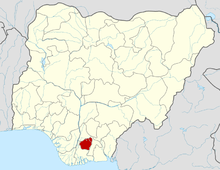 | |