Idaho State Highway 75
| ||||
|---|---|---|---|---|
.png) | ||||
| Route information | ||||
| Maintained by ITD | ||||
| Length: | 170.666 mi[1] (274.660 km) | |||
| Tourist routes: |
(Stanley to Challis) | |||
| Major junctions | ||||
| South end: |
| |||
|
| ||||
| North end: |
| |||
| Location | ||||
| Counties: | Lincoln, Blaine, and Custer counties | |||
| Highway system | ||||
| ||||

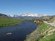
from Lower Stanley
State Highway 75 is a two-lane highway that travels through the Sawtooth Valley of central Idaho. The highway's southern terminus is in Shoshone, and its northern is near Challis. It is designated as one of Idaho's scenic byways and provides access to Sawtooth National Recreation Area. It primarily follows the Big Wood River in the south and the main Salmon River in the north, divided by Galena Summit.
Route description
State Highway 75 begins at a junction with US-93 on Greenwood Street in Shoshone at an elevation of just under 4,000 feet (1,220 m) above sea level. The highway heads northward, and ascends the Big Wood River valley, into Blaine County, past the Magic Reservoir to the west and crosses US-20 at Timmerman Junction at 4,884 feet (1,489 m).
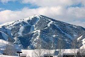
It continues northward as the Sawtooth Scenic Byway[2] to pass through the Big Wood River communities of Bellevue, Hailey, and Ketchum. Sun Valley is accessible via a spur route junction in Ketchum at Third Street, which becomes Sun Valley Road.
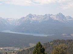
Seven miles (11 km) north of Ketchum, the highway passes by the headquarters of the Sawtooth National Recreation Area at 6,250 feet (1,905 m) and the Boulder Mountains to the north, with peaks over 11,000 feet (3,350 m). SH-75 climbs past the Galena Lodge to the Galena Summit at 8,701 feet (2,652 m), then descends to the scenic viewpoint about a mile later, which overlooks the Sawtooth Mountains to the west and headwaters of the Salmon River in the Sawtooth Valley.
Highway 75 descends the grade and reaches the upper end of the valley floor at new Sawtooth City at 7,190 feet (2,192 m), and then enters Custer County. It runs northward down the valley with the Salmon River to Obsidian and Stanley, with the Sawtooths to the immediate west and the White Cloud Mountains to the slightly more distant east. The turnoff to picturesque Redfish Lake is about five miles (8 km) south of Stanley.
At Stanley, the highway intersects with the northern terminus of State Highway 21, the Ponderosa Pine Scenic Byway from Boise, through Idaho City and Lowman.[3] The junction is at 6,250 feet (1,900 m) and Highway 75 northbound becomes the Salmon River Scenic Byway, continuing north for a mile, then veering east and descending with the twisty river towards Clayton. Both then head north towards Challis, where the route terminates and rejoins US-93 just south of the city limits,[4] at an elevation of 5,004 feet (1,525 m).
History
In 1824, while searching the mountain wilderness of what is presentday Idaho, known to them as Columbia District, for beaver, Alexander Ross came up the Wood River and discovered Galena Summit on September 18. Leading a large brigade of Hudson's Bay Company trappers, he wondered if he could get through unknown mountains and rocky defiles that obstructed his passage back to his base of operations at present Challis. Unwilling to turn back he pressed on to explore Stanley Basin and the difficult canyon beyond. When he reached Challis on October 5, 1824, he had traveled the route now followed by Idaho State Highway 75 from Bellevue to Salmon through mostly unexplored land.
The road itself dates back to at least 1926, when it was designated U.S. Route 93. The former U.S. Route 93 Alternate, running through Arco,[5] was redesignated as U.S. Route 93 in 1977, and at that time this route was given its current state highway designation.[6]
Major intersections
| County | Location | mi[1] | km | Destinations | Notes |
|---|---|---|---|---|---|
| Lincoln | Shoshone | 73.659 | 118.543 | ||
| Blaine | Timmerman Junction | 102.124 | 164.353 | ||
| Ketchum | 128.376 | 206.601 | Sun Valley Road - (3rd St) | ||
| Galena Summit | 157.954 | 254.202 | elevation = 8,701 feet (2,652 m) | ||
| Custer | Stanley | 189.378 | 304.774 | (southbound) | |
| Challis | 244.325 | 393.203 | |||
| 1.000 mi = 1.609 km; 1.000 km = 0.621 mi | |||||
References
- 1 2 "State Highway 75 Milepoint Log" (PDF). Idaho Transportation Department. May 15, 2015. Retrieved October 24, 2015.
- ↑ "Sawtooth Scenic Byway". Visit Idaho. Retrieved October 24, 2015.
- ↑ "Ponderosa Pine Scenic Byway". Visit Idaho. Retrieved October 24, 2015.
- ↑ "Salmon River Scenic Byway". Visit Idaho. Retrieved October 24, 2015.
- ↑ "Map of US highway 93". USends.com. Retrieved October 24, 2015.
- ↑ U.S. Route 93 Alternate Idaho's US Highways
External links
| Wikimedia Commons has media related to Idaho State Highway 75. |
- Idaho Transportation Dept. – Milepost log – State Highway 75
- Roadcams – State Highway 75
- Proto Photo.com - Scenic Route 75
- David Rumsey Map Collection – Historic road map (1937) – Idaho, Montana, Wyoming – Texaco (Rand McNally)
- Idaho highway map (1956) – Shell (H.M. Gousha)