Ichikawa, Chiba
| Ichikawa 市川市 | |||
|---|---|---|---|
| City | |||
|
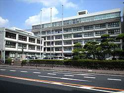
Ichikawa City Office | |||
| |||
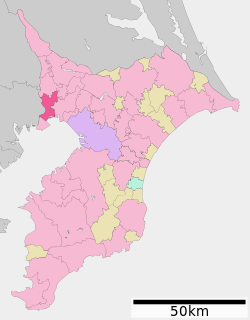 Location of Ichikawa in Chiba Prefecture | |||
 Ichikawa
| |||
| Coordinates: 35°43′18.9″N 139°55′51.8″E / 35.721917°N 139.931056°ECoordinates: 35°43′18.9″N 139°55′51.8″E / 35.721917°N 139.931056°E | |||
| Country | Japan | ||
| Region | Kantō | ||
| Prefecture | Chiba Prefecture | ||
| Government | |||
| • - Mayor | Hiroshi Okubo (since December 2009) | ||
| Area | |||
| • Total | 57.45 km2 (22.18 sq mi) | ||
| Population (February 2016) | |||
| • Total | 481,790 | ||
| • Density | 8,390/km2 (21,700/sq mi) | ||
| Time zone | Japan Standard Time (UTC+9) | ||
| - Tree | Pinus thunbergii | ||
| - Flower | Rose | ||
| - Bird | Cettia diphone | ||
| Phone number | 047-334-1111 | ||
| Address | 1-1-1 Yawata, Ichikawa-shi, Chiba-ken 272-8501 | ||
| Website | Official website | ||


Ichikawa (市川市 Ichikawa-shi) is a city located in northwestern Chiba Prefecture, Japan, approximately 20 kilometers from the center of Tokyo. The city was founded on November 3, 1934.
As of February 1, 2016, the city had an estimated population of 481,790 and a population density of 8,390 persons per km². The total area is 57.45 km2 (22.18 sq mi).
Ichikawa is also the home of the chief of the ground staff of the Japan Ground Self-Defense Force and the Colton Plaza shopping mall. Its close proximity to Tokyo makes it a convenient location for commuters; it is connected to Tokyo by the JR Chuo-Sobu Line, the Toei Shinjuku Line, the Tokyo Metro Tozai Line, the Toei Asakusa Line, and the Keisei Line.
Geography
Ichikawa is located on the alluvial plain of the Edogawa River on the northern end of Tokyo Bay, with Tokyo Metropolis forming its western border. Much of the city is near sea level in altitude.
Surrounding municipalities
Chiba Prefecture
Tokyo Metropolis
History
The area around present-day Ichikawa has been inhabited since the Japanese Paleolithic period. Archaeologists have found stone tools dating to some 30,000 years ago. Numerous shell middens from the Jōmon period, and hundreds of burial tumuli from the Kofun period have been found in numerous locations around Ichikawa. During the Nara period, Ichikawa was the provincial capital of Shimōsa Province and is mentioned in the Man'yōshū. During the Heian period, this area was the center of the rebellion by Taira Masakado. During the Sengoku period, it was the site of a major battles (Battle of Kōnodai) between the Satomi clan and the Late Hōjō clan.
In more recent history, the area was also the site of some minor battles during the Boshin War of the Meiji Restoration and was promoted as a possible site for the new Diet of Japan by Katsu Kaishu, who envisioned a structure to be built on the Edogawa River similar to the Houses of Parliament in London along the Thames. Ichikawa Town was organized in 1889. On November 3, 1934 it merged with the neighboring towns of Yawata, Nakayama and village of Kokubun to form the city of Ichikawa. The city expanded by annexing the village of Okashiwa on November 3, 1949, the town of Gyotoku on March 31, 1955 and town of Minami-Gyotoku on October 1, 1956.
Transportation
Railway
- East Japan Railway Company (JR East) - Sōbu Line (Rapid)
- East Japan Railway Company (JR East) - Chūō-Sōbu Line
- East Japan Railway Company (JR East) - Musashino Line
- East Japan Railway Company (JR East) - Keiyō Line
- Keisei Electric Railway - Keisei Main Line
- Kōnodai - Ichikawa-Mama - Sugano - Keisei Yawata - Onigoe - Keisei Nakayama
- Tokyo Metropolitan Bureau of Transportation - Shinjuku Line
- Tokyo Metro - Tōzai Line
- Hokusō Railway - Hokusō Line
Highway
- Higashi-Kantō Expressway
- Keiyō Road
- Bayshore Route
- Japan National Route 14
- Japan National Route 298
- Japan National Route 296
- Japan National Route 357
- Japan National Route 464
Education
Universities
- Chiba University of Commerce
- Wayo Women's University
- Tokyo Medical and Dental University (Ichikawa campus)
- Showagakuin Junior College
- Tokyo Management College
Primary and secondary schools
- Ichikawa has 39 public elementary schools and three private elementary schools. The city has 27 public middle schools and five private combined middle/high schools, including Ichikawa Gakuen. The city also has seven public high schools and two private high schools.
Twin towns – Sister cities
-
 Medan, North Sumatera, Indonesia, from November 4, 1989.[1][2]
 -
 Gardena, California, United States from November 6, 1962[3]
 -
 Leshan, People's Republic of China, from October 21, 1981[4] (Hometown of Guo Moruo, resident in Ichikawa 1927-37)
 -
 Rosenheim, Germany, from July 14, 2004.[5]
 -
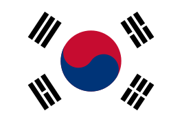 Wonju, South Korea
Local attractions
- Nakayama Hokekyō-ji: A Buddhist temple with several national important cultural assets, including a gate and a Hokke-dō Hall from the Sengoku period and a Five-story Pagoda built in 1622.
- Katsushika Hachiman Shrine: A Shinto shrine built in the Heian period.
- Osu Disaster Prevention Park: Usually used as a recreation and relaxation site, this park is designated as a temporary evacuation and rescue site in times of disaster.
- Satomi Park: One of Ichikawa's main parks, Satomi Park stands on the hilly part of Konōdai, with the Edo River running below. It is famous for its cherry trees.
- Wild Bird Observatory: This facility is equipped with observation telescopes, and it has an exhibition room which is open to visitors.
- Zoological & Botanical Garden: This garden houses 70 species of animals, mainly small animals such as lesser pandas and orangutans. Nearby is the Natural Museum, Nature Park (Rose Garden), Youth Nature House (Planetarium), and privately managed athletic facilities.
- Teramachi-dori: Formerly called "Narita-michi" ("Narita Road"), this street was once used by pilgrims on their way to Narita-san Temple.
- Guhō-ji and the nearby Mama Well of Kamei-in, mentioned in Takahashi Mushimaro's poem in the Man'yōshū
- Higashiyama Kaii Memorial Hall: Designed based on Germany, where Higashiyama studied, this two-story building is European in appearance with an octagonal tower.
- Lifelong Learning Center: Nicknamed "Media Park Ichikawa," this center supports learning for everyone from infants to seniors. The center's main attraction is the Central Library, along with the Audio Visual and Children's Hall.
- Clean Spa Ichikawa: Powered by heat from garbage incineration, this facility provides a swimming pool, warm bath, and gymnastic equipment.
Noted people from Ichikawa
- Sakaigawa Namiemon – Meiji period sumo wrestler
- Wakashima Gonshirō – Meiji period sumo wrestler
- Kōji Nakano – novelist
- Kuniko Inoguchi – Cabinet minister
- Michio Hoshino – photographer
- Kazuki Kosakai – comedian
- Yūko Andō – newscaster
- Koji Ishikawa – illustrator
- Taiji – musician
- yukihiro (musician) – musician
- Kazuo Takahashi – mixed martial artist
- Shigeki Maruyama – professional golfer
- Oginishiki Yasutoshi – sumo wrestler
- Tomo Sakurai – Voice actress
- Tōki Susumu – sumo wrestler
- Ryoji Aikawa – professional baseball player
- Ryoji Aikawa – professional soccer player
- Kazushige Nosawa – professional wrestler
- G.G. Sato – professional baseball player
- Moe Oshikiri – fashion model
- Yuki Abe – professional soccer player
- Atsuko Maeda – AKB48 singer
- Norimitsu Onishi – Journalist
- Tatsuhisa Suzuki – Voice actor
- Peter Takeo Okada – Roman Catholic Archbishop of Tokyo
- Yoko Narahashi - Prominent Japanese film producer and casting director
References
- ↑ http://www.pemkomedan.go.id/news_detail.php?id=106 MEDAN MENJALIN HUBUNGAN KOTA KEMBAR KEEMPAT Retrieved September 10, 2013 Archived 23 April 2007
- ↑ Medan City
- ↑ Gardena
- ↑ LESHAN CITY 楽山市
- ↑ Rosenheim
External links
| Wikimedia Commons has media related to Ichikawa, Chiba. |
- Official website
- Association of Ichikawa Sightseeing official website (Japanese)
- Ichikawa-FM official website (Japanese)
| Wards of Chiba | ||
|---|---|---|
| Core cities | ||
| Cities | ||
| Inba District | ||
| Katori District | ||
| Sanbu District | ||
| Chōsei District | ||
| Isumi District | ||
| Awa District | ||