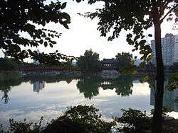
Icheon
| Icheon 이천시 | |
|---|---|
| Municipal City | |
| Korean transcription(s) | |
| • Hangul | 이천시 |
| • Hanja | 利川市 |
| • Revised Romanization | Icheon-si |
| • McCune–Reischauer | Ich'ŏn-si |
 | |
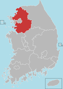
 Location in South Korea | |
| Country |
|
| Region | Sudogwon |
| Province | Gyeonggi |
| Administrative divisions | 2 eup, 8 myeon, 4 dong |
| Area | |
| • Total | 461.3 km2 (178.1 sq mi) |
| Population (2016) | |
| • Total | 215,206 [1] |
| • Density | 453/km2 (1,170/sq mi) |
| • Dialect | Seoul |
| Website | icheon.go.kr |
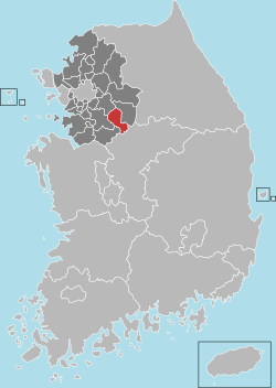
Icheon is a city in Gyeonggi Province, South Korea. It should not be confused with the much larger Incheon Metropolitan City. Neighboring districts include Yeoju County, Gwangju City, Yongin City, and Anseong City within Gyeonggi Province, as well as Eumseong County in North Chungcheong Province. Together with Yeoju, Icheon is known as a center of South Korean ceramic manufacturing and is a UNESCO City of Crafts and Folk Art. Other famous local products include peaches and rice. Local institutions of higher learning include Korea Tourism College and Chungkang College of Cultural Industries.
The Yeongdong Expressway and Jungbu Naeryuk Expressway pass through Icheon. In 2016, the city will connect into the Seoul Metropolitan Subway via Yeoju Line's Icheon Station.[2]
Icheon is home to Hynix, the world's second largest memory chip maker.
Administrative divisions
Dongnam-gu is divided into 2 towns (eup), 8 townships (myeon), and 4 neighbourhoods (dong).
| Hangul | Hanja | |
|---|---|---|
| Janghowon-eup | 장호원읍 | 長湖院邑 |
| Bubal-eup | 부발읍 | 夫鉢邑 |
| Sindun-myeon | 신둔면 | 新屯面 |
| Baeksa-myeon | 백사면 | 栢沙面 |
| Hobeop-myeon | 호법면 | 戶法面 |
| Majang-myeon | 마장면 | 麻長面 |
| Daewol-myeon | 대월면 | 大月面 |
| Moga-myeon | 모가면 | 暮加面 |
| Seolseong-myeon | 설성면 | 雪星面 |
| Yul-myeon | 율면 | 栗面 |
| Changjeon-dong | 창전동 | 倉前洞 |
| Jeungpo-dong | 증포동 | 增浦洞 |
| Jungni-dong | 중리동 | 中里洞 |
| Gwango-dong | 관고동 | 官庫洞 |
City Symbols
- City Bird : Magpie
- City Flower : Azaleas
- City Tree : Pine
Climate
| Climate data for Icheon (1981–2010) | |||||||||||||
|---|---|---|---|---|---|---|---|---|---|---|---|---|---|
| Month | Jan | Feb | Mar | Apr | May | Jun | Jul | Aug | Sep | Oct | Nov | Dec | Year |
| Average high °C (°F) | 2.8 (37) |
6.3 (43.3) |
12.1 (53.8) |
19.3 (66.7) |
24.2 (75.6) |
27.5 (81.5) |
29.0 (84.2) |
29.9 (85.8) |
25.8 (78.4) |
20.4 (68.7) |
12.0 (53.6) |
4.7 (40.5) |
17.8 (64) |
| Daily mean °C (°F) | −3.1 (26.4) |
−0.2 (31.6) |
5.2 (41.4) |
11.9 (53.4) |
17.4 (63.3) |
21.7 (71.1) |
24.4 (75.9) |
24.8 (76.6) |
19.8 (67.6) |
13.0 (55.4) |
5.4 (41.7) |
−1.2 (29.8) |
11.6 (52.9) |
| Average low °C (°F) | −8.5 (16.7) |
−6.1 (21) |
−1.0 (30.2) |
4.9 (40.8) |
11.1 (52) |
16.6 (61.9) |
20.7 (69.3) |
21.0 (69.8) |
15.0 (59) |
7.2 (45) |
−0.2 (31.6) |
−6.4 (20.5) |
6.2 (43.2) |
| Average precipitation mm (inches) | 22.5 (0.886) |
23.9 (0.941) |
47.4 (1.866) |
74.0 (2.913) |
93.8 (3.693) |
146.0 (5.748) |
370.2 (14.575) |
319.9 (12.594) |
176.0 (6.929) |
42.1 (1.657) |
38.8 (1.528) |
16.3 (0.642) |
1,370.8 (53.969) |
| Average precipitation days (≥ 0.1 mm) | 6.0 | 4.6 | 7.2 | 7.0 | 7.6 | 9.4 | 14.6 | 13.8 | 9.0 | 5.0 | 7.1 | 6.1 | 97.4 |
| Average relative humidity (%) | 64.4 | 59.9 | 58.0 | 55.3 | 62.1 | 67.8 | 77.3 | 76.9 | 74.5 | 70.4 | 67.1 | 66.6 | 66.7 |
| Mean monthly sunshine hours | 166.1 | 169.1 | 192.1 | 210.8 | 221.8 | 187.0 | 141.2 | 159.4 | 165.6 | 188.4 | 152.6 | 158.3 | 2,113.7 |
| Source: Korea Meteorological Administration[3] | |||||||||||||
Ceramic village
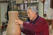
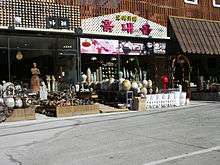
The Icheon Ceramics Village features 300-plus ceramics-making firms in the area of Sugwang-ri, Sindun-myeon, Saeum-dong, and a popular visitor attraction.[4] They use traditional skills and produce porcelains in some 40 traditional firewood kilns. This pottery is recognized both at home and abroad for its quality.
The Saeum-dong and Sindun-myeon areas also include a ceramics village with many ceramics stores. Potters have researched traditional methods and revived the manufacture of ceramics in the style of Goryeo celadon and Joseon white porcelain here. The village is the center of the effort to preserve these traditions.[5]
Sister cities
 Jingdezhen city, China (1997)
 Seto city, Japan (2004)
 Gangdong, South Korea
- Gangnam, South Korea
 Santa Fe, New Mexico, United States (2013)
 Limoges, France (2015)
Famous people
- Seo Hui : The historic figure of Goryeo dynasty who made a huge decision with Khitan people who was forcefully occupying northern areas of Korean peninsula.
See also
References
- ↑ 이천시청 기본현황 - Icheon City
- ↑ "Yeoju Line Set to Open in 2016". Kojects. Retrieved 2016-01-04.
- ↑ "평년값자료(1981–2010) 이천(203)". Korea Meteorological Administration. Retrieved 2011-05-02.
- ↑ "Icheon". Lonely Planet. Retrieved 2014-10-19.
- ↑ Official pages of Icheon city
External links
| Wikimedia Commons has media related to Icheon, Gyeonggi-do. |
Suwon (capital) | ||||||||||||||||||||||||||||||||||||
 | Specific cities |
| ||||||||||||||||||||||||||||||||||
| Cities | ||||||||||||||||||||||||||||||||||||
| Counties | ||||||||||||||||||||||||||||||||||||
Coordinates: 37°16′N 127°26′E / 37.267°N 127.433°E