Ibn Firnas (crater)
|
Apollo 16 mapping camera image | |
| Coordinates | 6°48′N 122°18′E / 6.8°N 122.3°ECoordinates: 6°48′N 122°18′E / 6.8°N 122.3°E |
|---|---|
| Diameter | 89 km |
| Depth | Unknown |
| Colongitude | 239° at sunrise |
| Eponym | Abbas Ibn Firnas |
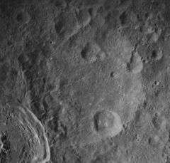

Ibn Firnas is a lunar impact crater on the far side of the Moon, in honour of Abbas Ibn Firnas, a polymath from Andalucia who, in the 9th century, devised a chain of rings that could be used to simulate the motions of the planets and stars.
Attached to the exterior of its southwestern rim is the prominent crater King. Only a few kilometers to the north, separated by a rugged stretch of terrain, is the larger crater Ostwald. This is a worn and eroded crater with small impacts along the northern and eastern rims. The satellite crater Ibn Firnas L lies along the inner wall to the southeast and covers part of the interior floor. Along the northern side, the small satellite crater Ibn Firnas Y cuts through the rim and overlays part of the inner wall. The interior floor is irregular along the northern and southwest sections where their shape has been modified by the large nearby craters mentioned above. Several small craterlets lie across the remainder of the interior floor.
Prior to naming in 1976 by the IAU,[1] this crater was known as Crater 213.[2]
Nearby craters
Several small craters located in the rugged terrain at the northern edge of this crater have been assigned names by the IAU. These are listed in the table below.
| Crater | Coordinates | Diameter | Name source |
|---|---|---|---|
| Carol | 8°30′N 122°18′E / 8.5°N 122.3°E | 8 km | Latin feminine name |
| Ewen | 7°42′N 121°24′E / 7.7°N 121.4°E | 3 km | Gaelic masculine name |
| Kasper | 8°18′N 122°06′E / 8.3°N 122.1°E | 12 km | Polish masculine name |
| Melissa | 8°06′N 121°48′E / 8.1°N 121.8°E | 18 km | Greek feminine name |
| Romeo | 7°30′N 122°36′E / 7.5°N 122.6°E | 8 km | Italian masculine name |
| Shahinaz | 7°30′N 122°24′E / 7.5°N 122.4°E | 15 km | Turkish feminine name |
The crater Melissa lies across the north-northwestern outer rim of Ibn Firnas. It is a roughly bowl-shaped, although it has a very uneven appearance due to the irregular terrain in which it was formed. Melissa was previously designated Ibn Firnas Y before it was assigned a name by the IAU.
The locations of these craters are shown on the following L&PI topographic maps:
Satellite craters
By convention these features are identified on lunar maps by placing the letter on the side of the crater midpoint that is closest to Ibn Firnas.
| Ibn Firnas | Latitude | Longitude | Diameter |
|---|---|---|---|
| E | 7.5° N | 125.5° E | 42 km |
| L | 5.9° N | 123.0° E | 21 km |
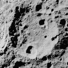
 Oblique view of Ibn Firnas E from Apollo 10
References
- ↑ Ibn Firnas, Gazetteer of Planetary Nomenclature, International Astronomical Union (IAU) Working Group for Planetary System Nomenclature (WGPSN)
- ↑ Lunar Farside Chart (LFC-1A)
- Andersson, L. E.; Whitaker, E. A. (1982). NASA Catalogue of Lunar Nomenclature. NASA RP-1097.
- Blue, Jennifer (July 25, 2007). "Gazetteer of Planetary Nomenclature". USGS. Retrieved 2007-08-05.
- Bussey, B.; Spudis, P. (2004). The Clementine Atlas of the Moon. New York: Cambridge University Press. ISBN 978-0-521-81528-4.
- Cocks, Elijah E.; Cocks, Josiah C. (1995). Who's Who on the Moon: A Biographical Dictionary of Lunar Nomenclature. Tudor Publishers. ISBN 978-0-936389-27-1.
- McDowell, Jonathan (July 15, 2007). "Lunar Nomenclature". Jonathan's Space Report. Retrieved 2007-10-24.
- Menzel, D. H.; Minnaert, M.; Levin, B.; Dollfus, A.; Bell, B. (1971). "Report on Lunar Nomenclature by the Working Group of Commission 17 of the IAU". Space Science Reviews. 12 (2): 136–186. Bibcode:1971SSRv...12..136M. doi:10.1007/BF00171763.
- Moore, Patrick (2001). On the Moon. Sterling Publishing Co. ISBN 978-0-304-35469-6.
- Price, Fred W. (1988). The Moon Observer's Handbook. Cambridge University Press. ISBN 978-0-521-33500-3.
- Rükl, Antonín (1990). Atlas of the Moon. Kalmbach Books. ISBN 978-0-913135-17-4.
- Webb, Rev. T. W. (1962). Celestial Objects for Common Telescopes (6th revised ed.). Dover. ISBN 978-0-486-20917-3.
- Whitaker, Ewen A. (1999). Mapping and Naming the Moon. Cambridge University Press. ISBN 978-0-521-62248-6.
- Wlasuk, Peter T. (2000). Observing the Moon. Springer. ISBN 978-1-85233-193-1.