Iberville Projects
| Iberville Projects | |
| New Orleans Neighborhood | |
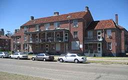 Iberville Projects on Basin Street | |
| Country | United States |
|---|---|
| State | Louisiana |
| City | New Orleans |
| Planning District | District 4, Mid-City District |
| Elevation | 0 ft (0.0 m) |
| Coordinates | 29°57′34″N 90°04′25″W / 29.95944°N 90.07361°WCoordinates: 29°57′34″N 90°04′25″W / 29.95944°N 90.07361°W |
| Area | 0.06 sq mi (0.2 km2) |
| - land | 0.06 sq mi (0 km2) |
| - water | 0.00 sq mi (0 km2), 0% |
| Population | 1,238 (2010) |
| Density | 20,633/sq mi (7,966/km2) |
| Timezone | CST (UTC-6) |
| - summer (DST) | CDT (UTC-5) |
| Area code | 504 |
Iberville Projects were a neighborhood in the city of New Orleans and one of the low-income Housing Projects of New Orleans. Its boundaries were St. Louis Street to the north, Basin Street to the east, Iberville Street to the south and North Claiborne Avenue to the west. It is located in the 4th Ward of downtown New Orleans, on the former site of the Storyville district. The area is currently being redeveloped.
Geography
The Iberville Projects were located at 29°57′34″N 90°04′25″W / 29.95944°N 90.07361°W [1] and has an elevation of 0 feet (0 m)[2] (mean sea level). According to the United States Census Bureau, the district has a total area of 0.06 square miles (0.2 km2), all of which is land.
The City Planning Commission defines the boundaries of Iberville Projects as these streets: St. Louis Street, Basin Street, Iberville Street and North Claiborne Avenue.[3]
History
20th century
The Iberville development was built on a ten block site in the early 1940s as part of the Wagner Bill. The land was previously Storyville, the city's official red light district. In 1940, the city declared 95% of the structures in Storyville substandard, clearing the way for construction of the project. There are 858 units in the Iberville.
During segregation, the Iberville was occupied by whites, while the nearby Lafitte Projects served the black tenants.
21st century
While the Iberville was closed following Hurricane Katrina, the project was one of the first to reopen. There was no significant damage.
New Orleans mayor Ray Nagin expressed a desire to redevelop the Iberville Projects as early as 2003.[4] In May 2009, Nagin announced a HANO proposal to raze part of it for redevelopment into mixed-income housing. [5]
Demolition of the Iberville Housing projects commenced in September 2013. Mixed income housing will be built on the site will be incorporated into the street grid of the surrounding neighborhoods. Human remains from the adjacent cemetery were found on a significant portion of the site, delaying redevelopment plans for months. These areas will be made into green space.
The remaining buildings from the original project were added to the National Register of Historic Places on January 5, 2015.[6]
Demographics
As of the census of 2000, there were 2,540 people, 830 households, and 689 families residing in the neighborhood.[7] The population density was 42,333 /mi² (12,700 /km²).
As of the census of 2010, there were 1,238 people, 482 households, and 295 families residing in the neighborhood.[7]
Adjacent neighborhoods
- Tremé (north)
- French Quarter (east)
- Central Business District (south)
- Tulane/Gravier (west)
| Wikimedia Commons has media related to Iberville Projects. |
References
- ↑ "US Gazetteer files: 2010, 2000, and 1990". United States Census Bureau. 2011-02-12. Retrieved 2011-04-23.
- ↑ "US Board on Geographic Names". United States Geological Survey. 2007-10-25. Retrieved 2008-01-31.
- ↑ Greater New Orleans Community Data Center. "Iberville Development Neighborhood". Retrieved 2008-06-21.
- ↑ Pandolfi, Keith (2003). "Canal Street redevelopment placed on hold for six months". New Orleans CityBusiness.
- ↑ Shaban, Bigad (May 20, 2009). "In address, Nagin announces several big plans". Eyewitness News. Archived from the original on 2009-05-22. Retrieved October 23, 2013.
- ↑ "Weekly List of Actions Taken on Properties: 1/05/15 Through 1/09/15". National Park Service. Retrieved January 17, 2015.
- 1 2 "Iberville Neighborhood". Greater New Orleans Community Data Center. Retrieved 6 January 2012.