Hygiene, Colorado
| Hygiene, Colorado | |
|---|---|
| Unincorporated community | |
|
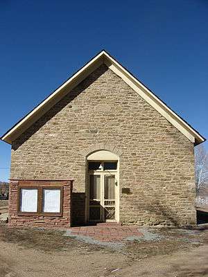
Church of the Brethren in Hygiene | |
 Hygiene, Colorado Location within the state of Colorado | |
| Coordinates: 40°11′21.84″N 105°10′39.36″W / 40.1894000°N 105.1776000°WCoordinates: 40°11′21.84″N 105°10′39.36″W / 40.1894000°N 105.1776000°W | |
| Country |
|
| State |
|
| Counties | Boulder[1] |
| Elevation[1] | 5,095 ft (1,553 m) |
| Time zone | MST (UTC-7) |
| • Summer (DST) | MDT (UTC-6) |
| ZIP code[2] | 80533 |
| GNIS feature ID | 178333 |
Hygiene is an unincorporated community with a U.S. Post Office in Boulder County, Colorado, United States. Application for the first Hygiene Post Office was made by Rev. Jacob Stoner Flory of the United Church of the Brethren on May 28, 1883[3] ZIP Code 80533. This community's name stems from a time when it had a sanitarium to work with tuberculosis patients.[4]
The prestigious Hygiene Home was developed by Jacob S. Flory. Articles of Incorporation were filed with the Boulder County Clerk as the Crystal Fountains, Hygienic Home, and White Sulphur Springs Company. A Warranty Deed was obtained for the property adjacent to the present Hygiene Elementary School on January 31, 1882.[5] An advertisement in the "Longmont Ledger" April 13, 1883 announced that the Hygiene Home was open for the season.
The Brethren Church is no longer in use as a church. The building is owned by the cemetery association. As of summer, 2013, it is in the process of restoration. The community association has held some of its meetings in the church building in 2013–2015.
Hygiene has a US Post Office (80533), a church (Hygiene United Methodist Church), a school (Hygiene Elementary) and a cemetery.
The Hygiene Community Association was formed in 2011 to preserve historical information and promote the community. Also see Economy below.
"Hygiene Hay Days" was created as an autumn community festival by Hygiene business owners in 2012. In 2013 the festival was organized by a cooperative effort of business owners and the Hygiene Community Association. The festival was held again, larger, in 2014.
The BNSF Railway has trackage on the south edge of Hygiene which is a branch line connecting Longmont and the Cemex cement plant at Lyons, Colorado.
Geography
Hygiene is located at 40°11′21.84″N 105°10′39.36″W / 40.1894000°N 105.1776000°W (40.1894,-105.1776).
Economy
Companies located in and around Hygiene as of July 30, 2013 include:
- Aspen Moon, organic farming, landscaping, masonry
- Castle Keep, rental storage
- Clark's Hygiene RV Storage, parking/storage for RVs, sales of hay and propane
- Crane Hollow Cafe (formerly Hygiene Cafe)
- David Grace Chiropractor
- Harvey Nelson Equipment, farm equipment dealer
- Homegrown Herbals
- Hygiene Feed and Supply, traditional feed store
- Joyful Learning, K-12 educational enrichment academy
- Kyasky Woodworking LLC, cabinetry/furniture fine woodworking
- Mary's Market and Deli (formerly Clark's Market)
- Napp Landscape Services
- Praha, high-end Czech/continental cuisine restaurant
- Rabbit Brush Gallery, local arts/crafts
- Sol y Sombra organic farm, farm camps
- Sunflower Community Acupuncture - Community Style Acupuncture clinic
- Toohey & Sons - naturally grown produce and grass hay
See also
References
- 1 2 "US Board on Geographic Names". United States Geological Survey. 2007-10-25. Retrieved 2008-01-31.
- ↑ "ZIP Code Lookup". United States Postal Service. December 28, 2006. Archived from the original (JavaScript/HTML) on November 23, 2010. Retrieved December 28, 2006.
- ↑ Boulder County Post Offices A-L; Carnegie Branch Library for Local history
- ↑ Dawson, John Frank. Place names in Colorado: why 700 communities were so named, 150 of Spanish or Indian origin. Denver, CO: The J. Frank Dawson Publishing Co. p. 27.
- ↑ Boulder County Land records through ICRIS
Municipalities and communities of Boulder County, Colorado, United States | ||
|---|---|---|
| Cities |  | |
| Towns | ||
| CDPs | ||
| Unincorporated communities | ||
| Ghost town | ||
| Footnotes | ‡This populated place also has portions in an adjacent county or counties | |