Hurum
| Hurum kommune | |||
|---|---|---|---|
| Municipality | |||
 | |||
| |||
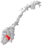
 Hurum within Buskerud | |||
| Coordinates: 59°36′11″N 10°31′5″E / 59.60306°N 10.51806°ECoordinates: 59°36′11″N 10°31′5″E / 59.60306°N 10.51806°E | |||
| Country | Norway | ||
| County | Buskerud | ||
| District | Lower Buskerud | ||
| Administrative centre | Sætre | ||
| Government | |||
| • Mayor (2011) | Monica Vee Bratli (H) | ||
| Area | |||
| • Total | 163 km2 (63 sq mi) | ||
| • Land | 156 km2 (60 sq mi) | ||
| Area rank | 354 in Norway | ||
| Population (2015) | |||
| • Total | 9 365 | ||
| • Rank | 120 in Norway | ||
| • Density | 56/km2 (150/sq mi) | ||
| • Change (10 years) | 11.5 % | ||
| Demonym(s) | Huring or Høring[1] | ||
| Time zone | CET (UTC+1) | ||
| • Summer (DST) | CEST (UTC+2) | ||
| ISO 3166 code | NO-0628 | ||
| Official language form | Bokmål | ||
| Website |
www | ||
|
| |||

Hurum is a municipality in Buskerud county, Norway. The administrative centre of the municipality is the village Sætre. The municipality of Hurum was established on 1 January 1838 (see formannskapsdistrikt). The small village of Holmsbu was granted town status in 1847, but it did not become a municipality of its own. It lost its town status on 1 January 1964.
Hurum was once suggested as the location for the new national airport of Norway. The plan was, however, abandoned, due to fears of too much fog in Hurum, and the main airport is now situated at Gardermoen in Akershus. It is famous also because it is the place where Morten Harket, the voice of the Norwegian band a-ha, lives (in Sætre).
General information
Name
The Old Norse form of the name was Húðrimar. The meaning of the first element (Húð) is unknown and the last element is the plural form of rimi which means "ridge".
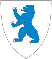
Coat-of-arms
The coat-of-arms is from modern times. They were granted on 2 February 1979. The arms show two blue wavy lines on a silver background. This was chosen because the municipality is on a peninsula between two fjords: Oslofjord and Drammensfjord. At the same time the arms are based on the arms of the Huitfeldt family, who played a major role in the local history. The family used a single bend as arms.[2]
Geography
The municipality borders Røyken to the north. To the west the coastline is located close to the eastern coast of Vestfold with Svelvik. It is connected to the eastern side of the Oslofjord via Oslofjordtunnel, one of the longest undersea tunnels of its kind in Northern Europe. The tunnel is 7.2 kilometres (4.5 mi) long and connects Hurumhalvøya to Akershus county.
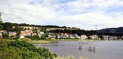
Hurum is located on the southern part of Hurumhalvøya, which is the peninsula between the Oslofjord and Drammensfjord. The administrative centre is the village of Sætre, which together with Tofte are one of the two most populated villages in Hurum.
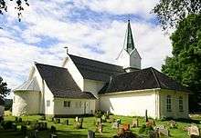
Hurum Church
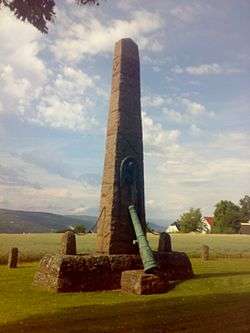
Hurum Church (Hurum kirke) is the parish church for Hurum. This is a medieval era church dating from ca. 1150. The edifice is constructed of stone and has 150 seats. The original church was ravaged by fire the night after Christmas Day 1686. The following year the church received a new roof and turret. In 1849 the church was extensively rebuilt. The interior has undergone a number of changes in the course of time. The cemetery is surrounded by stone wall and has a chapel from 1938. Naval hero and native son, Ivar Huitfeldt (1665-1710) was buried in the church yard. The pulpit was received as a gift from his wife, Kirsten Røyem Huitfeldt (1671–1750).[3][4]
References
- ↑ "Navn på steder og personer: Innbyggjarnamn" (in Norwegian). Språkrådet. Retrieved 2015-12-01.
- ↑ Norske Kommunevåpen (1990). "Nye kommunevåbener i Norden". Retrieved 2009-01-10.
- ↑ "Huitfeldt, Ivar, 1665-1710". Dansk biografisk Lexikon. Retrieved September 1, 2016.
- ↑ Sigrid Marie Christie, Håkon Christie. "Hurum kirke". Norges Kirker. Retrieved September 1, 2016.
External links
| Wikimedia Commons has media related to Hurum. |
| Look up Hurum in Wiktionary, the free dictionary. |