Hurricane Kristy (2006)
| Category 1 hurricane (SSHWS/NWS) | |
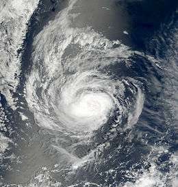 Hurricane Kristy near peak intensity | |
| Formed | August 30, 2006 |
|---|---|
| Dissipated | September 8, 2006 |
| Highest winds |
1-minute sustained: 80 mph (130 km/h) |
| Lowest pressure | 985 mbar (hPa); 29.09 inHg |
| Fatalities | None reported |
| Damage | None |
| Areas affected | No land areas |
| Part of the 2006 Pacific hurricane season | |
Hurricane Kristy in 2006 was a relatively long-lived tropical cyclone in the 2006 Pacific hurricane season. It developed on August 30 from a tropical wave off the southwest coast of Mexico, and quickly intensified to attain hurricane status, reaching peak winds of 80 mph (130 km/h). Subsequently, Kristy weakened from cooler waters and increased wind shear from Hurricane John to its northeast. Steering currents weakened, and turning to a southerly drift, it weakened to a tropical depression by September 2. The next day it briefly regained tropical storm status, only to again deteriorate to depression status. After turning to the west, Kristy encountered marginally favorable conditions and attained tropical storm status for a third time, though unfavorable conditions caused it to dissipate on September 9. The storm never affected land,[1] although initially there was a slight threat to Clarion Island.[2] Within the National Hurricane Center area of warning responsibility east of 140°W, Hurricane Kristy was the longest-lasting tropical cyclone of the season.
Genesis

A tropical wave moved off the west coast of Africa on August 13. With a large swirl of low clouds and little convection, the system tracked westward for two weeks across the Atlantic Ocean and Caribbean Sea, before crossing Central America on August 22.[1] On August 29, the system became better organized, consisting of a broad low pressure area and thunderstorm activity.[3] The convection persisted and organized further, and at 0000 UTC on August 30 it developed into Tropical Depression Twelve-E about 600 mi (970 km) southwest of the southern tip of the Baja California peninsula.[1]
Upon becoming a tropical cyclone, the depression was experiencing slight easterly wind shear, which distorted the convection to the west of the circulation. However, favorable conditions for strengthening were expected, and the depression was forecast to reach peak winds of 50 mph (85 km/h) before weakening.[4] It tracked slowly northwestward along the southern periphery of a ridge, and quickly intensified into Tropical Storm Kristy after convection increased over its circulation center. By that time, wind shear had decreased to very low levels, and with very warm waters, the storm was expected to quickly intensify to reach hurricane status.[5] By late on August 30, the convection was wrapping into the center while an eye feature became intermittent.[6] Organization continued, and Kristy attained hurricane status early on August 31, about 30 hours after forming.[1] Six hours after attaining hurricane status, an eye-like featured was evident on satellite imagery, and it is estimated Kristy attained peak winds of 80 mph (130 km/h) about 550 mi (880 km) southwest of the southern tip of the Baja California.[1] However, satellite-derived intensity estimates suggested the hurricane could have been as strong as 105 mph (170 km/h), or as weak as a tropical storm.[7]
Weakening and demise
Subsequently, wind shear increased, caused by the outflow of powerful Hurricane John to its east.[1] Additionally, the hurricane moved into an area of cooler water temperatures, and as a result its appearance became ragged and amorphous. At the same time, steering currents weakened, and the future of Kristy was uncertain; the NHC forecast the hurricane to continue slowly westward, dissipating within four days. However, other hurricane models suggested a motion to the southwest, and two models predicted a Fujiwhara effect, or an orbiting of two tropical cyclones, which would eventually result in Kristy being absorbed by Hurricane John.[8] On September 1, Kristy weakened to tropical storm status,[1] and it weakened faster as dry air encroached the storm.[9] It turned southeastward as the ridge to its north strengthened.[1] On September 2, the circulation became exposed from the convection, and it was forecast to degenerate into a remnant low within 24 hours.[10] Later that day, Kristy weakened to tropical depression status.[1]

By September 3, Tropical Depression Kristy was without persistent deep convection for about 18 hours.[11] However, thunderstorms increased around the center later that day, developing a shallow eye-like feature.[12] The convection persisted along the western periphery of the circulation, and it is estimated Kristy re-attained tropical storm status about 24 hours after it was first downgraded to depression status.[1][13] Around the same time, the cyclone began a steady motion to the southwest. Its re-intensification was short-lived, as continued wind shear weakened the convection and left the center devoid of any thunderstorms. On September 4, Kristy weakened to tropical depression status, and though quick dissipation was predicted, officials noted that intermittent convection flares could develop.[14] One such convection flare occurred on September 5, which persisted around the center and warranted Kristy being upgraded to tropical storm status. By that time, wind shear had decreased somewhat and the storm had turned westward, and with a track through warm water temperatures, Kristy was forecast to maintain tropical storm status for five days.[15]
At one point as a tropical storm, the thunderstorm activity around Kristy appeared to be organizing into hooking bands, and further intensification was considered likely, potentially as strong as 60 mph (95 km/h).[16] However, the thunderstorm activity decreased markedly on September 6,[17] primarily from dry air entrainment,[18] and it weakened to tropical depression status for the last time.[1] In one forecast, Kristy was predicted to move into the area of warning responsibility of the Central Pacific Hurricane Center, or west of 140°W.[19] However, the depression was unable to maintain organized convection around its center for a few days,[20] and Kristy degenerated into a remnant low on September 8. The low turned to the southwest, degenerating into a tropical wave on September 9 about 1500 miles (2400 km) southeast of the island of Hawaii, or about 1600 miles (2600 km) southwest of the southern tip of the Baja California peninsula.[1] The remnant disturbance continued westward, and initially Kristy was believed to have developed into Tropical Depression Two-C in the central Pacific Ocean; however, post-season analysis concluded the systems were separate.[21]
See also
References
- 1 2 3 4 5 6 7 8 9 10 11 12 Lixion Avila (2006-10-12). "Hurricane Kristy Tropical Cyclone Report" (PDF). National Hurricane Center. Retrieved 2008-11-17.
- ↑ Rhome/Franklin (2008-08-30). "Tropical Depression Twelve-E Wind Speed Probabilities Number One". National Hurricane Center. Retrieved 2008-11-21.
- ↑ Brown/Stewart (2006-08-29). "Tropical Weather Outlook". National Hurricane Center. Retrieved 2008-11-18.
- ↑ Rhome/Franklin (2006-08-30). "Tropical Depression Twelve-E Special Discussion One". National Hurricane Center. Retrieved 2008-11-18.
- ↑ Stewart (2006-08-30). "Tropical Storm Kristy Discussion Two". National Hurricane Center. Retrieved 2008-11-18.
- ↑ Pasch (2006-08-30). "Tropical Storm Kristy Discussion Four". National Hurricane Center. Retrieved 2008-11-18.
- ↑ Franklin (2006-08-31). "Hurricane Kristy Discussion Seven". National Hurricane Center. Retrieved 2008-11-18.
- ↑ Beven; et al. (2006-09-01). "Hurricane Kristy Discussion Nine". National Hurricane Center. Retrieved 2008-11-20.
- ↑ Mainelli/Avila (2006-09-01). "Tropical Storm Kristy Discussion Eleven". National Hurricane Center. Retrieved 2008-11-20.
- ↑ Fiorino/Avila (2006-09-02). "Tropical Storm Kristy Discussion Fifteen". National Hurricane Center. Retrieved 2008-11-20.
- ↑ Roberts/Beven (2006-09-03). "Tropical Depression Kristy Discussion Seventeen". National Hurricane Center. Retrieved 2008-11-20.
- ↑ Stewart (2006-09-03). "Tropical Depression Kristy Discussion Eighteen". National Hurricane Center. Retrieved 2008-11-20.
- ↑ Fiorino/Franklin (2006-09-03). "Tropical Storm Kristy Discussion Twenty". National Hurricane Center. Retrieved 2008-11-21.
- ↑ Avila (2006-09-04). "Tropical Depression Kristy Discussion Twenty-Two". National Hurricane Center. Retrieved 2008-11-21.
- ↑ Blake/Stewart (2006-09-05). "Tropical Storm Kristy Discussion Twenty-Seven". National Hurricane Center. Retrieved 2008-11-21.
- ↑ Blake/Stewart (2006-09-05). "Tropical Storm Kristy Discussion Twenty-Eight". National Hurricane Center. Retrieved 2008-11-21.
- ↑ Beven (2006-09-06). "Tropical Storm Kristy Discussion Thirty". National Hurricane Center. Retrieved 2008-11-21.
- ↑ Roberts/Franklin (2006-09-06). "Tropical Depression Kristy Discussion Thirty-Two". National Hurricane Center. Retrieved 2008-11-21.
- ↑ Pasch (2006-09-07). "Tropical Depression Kristy Discussion Thirty-Three". National Hurricane Center. Retrieved 2008-11-21.
- ↑ Berg/Avila (2006-09-08). "Tropical Depression Kristy Discussion Thirty-Seven". National Hurricane Center. Retrieved 2008-11-21.
- ↑ Central Pacific Hurricane Center (2008). "Mission Statement". Retrieved 2008-11-21.
Tropical cyclones of the 2006 Pacific hurricane season | ||
|---|---|---|
 | ||
| ||