Hurricane Fred (2015)
| Category 1 hurricane (SSHWS/NWS) | |
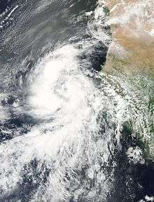
 Hurricane Fred over the Cape Verde Islands on August 31 | |
| Formed | August 30, 2015 |
|---|---|
| Dissipated | September 6, 2015 |
| Highest winds |
1-minute sustained: 85 mph (140 km/h) |
| Lowest pressure | 986 mbar (hPa); 29.12 inHg |
| Fatalities | 9 direct |
| Damage | > $1.1 million (2015 USD) |
| Areas affected | West Africa, Cape Verde |
| Part of the 2015 Atlantic hurricane season | |
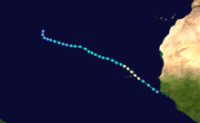
Hurricane Fred was the first hurricane[nb 1] to move through the Cape Verde Islands since 1892.[2] The second hurricane and sixth named storm of the 2015 Atlantic hurricane season, Fred originated from a well-defined tropical wave over West Africa in late August. Once offshore, the wave moved northwestward within a favorable tropospheric environment and strengthened into a tropical storm on August 30. The next day, Fred further grew to a Category 1 hurricane with peak winds of 85 mph (140 km/h) as it approached Cape Verde. After passing Boa Vista and moving away from Santo Antão, it entered a phase of steady weakening, dropping below hurricane status by September 1. Fred then turned to the west-northwest and endured increasingly hostile wind shear, but maintained its status as a tropical cyclone despite repeated forecasts of dissipation. It fluctuated between a minimal tropical storm and tropical depression through September 4–5 before curving sharply to the north. By September 6, Fred's circulation pattern had diminished considerably, and it dissipated later that day.
At the threat of the hurricane, all of Cape Verde was placed under a hurricane warning for the first time in history. Gale-force winds battered much of the Barlavento region through August 31, downing numerous trees and utility poles. On the easternmost islands of Boa Vista and Sal, Fred leveled roofs and left several villages without power and phone services for several days. About 70 percent of the houses in Povoação Velha were damaged to some degree. Throughout the northern islands, rainstorms damaged homes and roads, and São Nicolau lost large amounts of its crop and livestock. Monetary losses exceeded $1.1 million (2015 USD) across Cape Verde, though the rain's overall impact on the agriculture was positive. Swells from the hurricane produced violent seas along West African shores, destroying fishing villages and submerging large swaths of residential area in Senegal. Between the coasts of West Africa and Cape Verde, maritime incidents related to Fred resulted in nine deaths.
Meteorological history
Early on August 28, the National Hurricane Center (NHC) began monitoring a tropical wave—an elongated area of low air pressure—inland over West Africa.[3] Traced by widespread cloudiness, the wave tracked toward the open Atlantic throughout the remainder of the day.[4] A broad cyclonic rotation began to form within the lower atmosphere on August 29, near the Guinea coastline.[5] The disturbance veered toward the northwest and emerged offshore near Conakry around 18:00 UTC that day. At the time, the NHC predicted a favorable environment for tropical cyclone development within the next 48 hours.[6] Heavy thunderstorms thrived overnight and consolidated near a well-defined low-pressure center.[7][8] On the morning of August 30, satellite images and scatterometer data confirmed that a tropical depression had formed about 300 mi (480 km) west-northwest of Conakry, with wind speeds of 35 mph (55 km/h).[2]
Although tropical cyclones in the extreme eastern Atlantic are typically propelled westward by high pressure from a subtropical ridge,[9] this depression moved toward the northwest along a breach in the ridge, caused by another disturbance.[10] Its cyclonic structure steadily improved as a sharply curved rainband tightened around the center, resembling the precursor to an eye.[11] At 06:00 UTC on August 30, the depression was upgraded to Tropical Storm Fred about 390 mi (625 km) east-southeast of Praia, Cape Verde[2]—one of the four easternmost locations for a tropical storm since modern record-keeping began in 1851.[11] A steady trend of intensification set in while Fred trekked through a region with ample tropical moisture, light upper winds, and above-average sea surface temperatures.[12] The storm developed a thick, circular central dense overcast with good outflow, and the eye feature became well established at all levels of the circulation.[13][14] Based on these characteristics, as well as satellite estimates of 75 mph (120 km/h) winds, Fred was upgraded to a Category 1 hurricane at 00:00 UTC on August 31. Then centered 120 mi (195 km) east-southeast of Praia, Cape Verde,[2] it was the easternmost tropical cyclone ever to attain hurricane status in the tropical Atlantic.[nb 2][16]

A compact cyclone, Fred quickly reached its peak strength, with a minimum central pressure of 986 mbar (hPa; 29.12 inHg) and 85 mph (140 km/h) winds.[2] Through the rest of August 31, the hurricane traversed the Barlavento Islands of Cape Verde, barely skirting the southern coast of Boa Vista around 12:00 UC.[17] Gradually losing definition, the eye passed north of São Nicolau and then north-northeast of Santo Antão over the following 12 hours.[18][19] On September 1, drier air and stronger wind shear aloft dispersed the inner convection, causing Fred to weaken to a tropical storm.[20] High pressures began to rebuild to the north of the weakening storm, which turned it slightly toward the west-northwest over considerably cooler waters.[21][22] Through much of September 1–4, convective activity was limited to intermittent flare-ups, with the associated thunderstorms continuously blown away from the center by the strong upper winds. Despite the adverse environment and Fred's lack of stable convection, the storm retained a robust spiral of low-level clouds and gales during this period, defying the NHC's repeated forecasts of its dissipation.[23]
At 12:00 UTC on September 4, the NHC downgraded Fred to a tropical depression due to a waning wind circulation; though its winds briefly picked back up the next day, it continued as a depression with minimal convection throughout the remainder of its existence.[2] Concurrently, a deep-altitude disturbance a few hundred miles east of Bermuda began to erode the southern edge of the high-pressure ridge that Fred had circumnavigated throughout most of its journey.[24] This changed the steering pattern in the region, turning the depression abruptly to the north on September 6.[24][25] Over the next hours, Fred became increasingly diffuse as a result of its progressively worsening surroundings.[26] It officially lost its status as a tropical cyclone at 18:00 UTC, and degenerated into a trough about 1,210 mi (1,945 km) southwest of the Azores. The remnants were absorbed into a frontal boundary shortly thereafter.[2]
Preparations and impact
Cape Verde
A tropical storm warning was issued for Cape Verde upon the storm's formation, as well as a hurricane watch in light of forecasts for further development. When Fred showed definitive signs of strengthening, the alerts were replaced by a hurricane warning,[2] marking the first occasion of a hurricane-level threat in the nation's recorded history.[27] On the morning of August 31, TACV Cabo Verde Airlines suspended its flights from the capital of Praia to Dakar;[28] all operations at the airports of Boa Vista, Sal and São Vicente were halted soon after squally conditions across the islands.[29] Officials ordered shipping interests on all islands to remain in port and to secure their vessels.[30] A national music festival was canceled in Porto Novo, on the northernmost island of Santo Antão.[31]
As it traversed the easternmost Cape Verde Islands on the afternoon of August 31, Fred brought strong winds and thunderstorms to Boa Vista that uprooted trees, damaged roofs and plaster, and knocked out power to most of the population. Cellphone service from a local carrier went down due to a toppled transmission tower in Sal Rei.[32] Two inhabitants were taken to hospital when their home partially collapsed, but they remained in good condition.[29] Floods affected low-lying areas of Rabil and cut off the main road to surrounding towns, hampering mobilization efforts.[32][33] The southern village of Povoação Velha bore the brunt of the storm; about 70 percent of the houses experienced some degree of damage, from broken tiles and windows to crumbled walls,[34] with repair costs of 3 million escudos (2015 value; $30,000 in USD).[35] A compromised infrastructure left the village without power and telephone services for at least five days.[34] Throughout Boa Vista, Fred led to losses of 76 million escudos (U$770,000), an estimated 50 million (US$500,000) occurring in the private sector.[33]
Similar effects were felt in parts of the other eastern islands. Along the southern shore of Sal, Fred's storm surge sunk or stranded dozens of vessels and destroyed an important tourist pier in Santa Maria.[36] Hotels, restaurants, and other beach facilities were flooded, and roads in the town became impassable. High winds leveled the roof of a sport center at a gymnasium,[32] which had initially been set up as a storm shelter to about 100 citizens.[36] Elsewhere on the island, the hurricane knocked out power to homes in Palmeira,[32] and caused minor structural damage to Sal International Airport.[37] At the height of the storm, flooding forced nearly 130 people living in the impoverished outskirts of Terra Boa and Espargos to relocate to shelters.[32][38] On the island of Santiago, the most significant impact was due to heavy rainfall peaking at 6.3 inches (160 mm).[39] The rains filled a large dam in São Salvador do Mundo to maximum capacity, which prompted residents from adjacent areas to evacuate.[40] In São Miguel, floods and fallen trees obstructed traffic and caused 2 million escudos (US$20,000) in damage.[41]

Fred produced gusts and downpours across the northern Barlavento Islands, with a maximum 7.9 in (200 mm) of rainfall recorded on São Nicolau.[39] Many old trees were uprooted across that island, and several villages lost power.[42] The storm damaged 70 homes in Ribeira Brava, the main town, leaving several families homeless. Local farmers suffered great losses following the destruction of greenhouses and a farm.[43] Strong winds in Cabeçalinho downed power poles and wrecked the roof of a church.[44] In Carriçal, heavy rainfall and flooding ruined fruit and hydroponic crops, as well as damaging roads and homes.[45] Much of the island's livestock was lost in the storm.[46] Damage to homes and the agriculture—in particular banana and sugarcane[42]—on São Nicolau totaled 30 million escudos (US$305,000), although considerable disruptions in the infrastructure due to broken roads and telecommunication antennae were unaccounted for.[47] On the neighboring islands of São Vicente and Santo Antão, impact from the storm was mostly limited to power outages, floods, and damaged crops.[48] About 35 people in Porto Novo, on the latter island, were moved to secure locations. Flooding there isolated two neighborhoods[49] and destroyed carrot, cabbage, and tomato plantations.[50] On São Vicente, roads were closed in and around Laginha, and a few people suffered minor injuries when a tree fell on their car.[51]
Throughout Cape Verde, the hurricane displaced more than 50 families[52] and caused 108 million escudos (US$1.1 million) in damage, largely to the agricultural and private sectors of the Barlavento region. Although there were no casualties onshore,[52] two fishermen navigating through the storm were presumed dead after never returning to port in Boa Vista.[53] Nonetheless, rainfall from Fred had a generally positive effect on the larger-scale agriculture of the islands, refilling many rivers and dams and irrigating drought-stricken farmland across the Sotavento region.[39][40]
West Africa
Swells from Fred reached stretches of West African coastline, producing high surf as far north as Senegal. Along the shores of Dakar, rough seas devastated fishing districts and harbor towns, stranding boats and damaging roads and bridges. About 200 houses were demolished in the district of Hann, many of which experienced total wall collapse.[54] In the suburb of Rufisque, the waves overtopped dams, entered homes and cemeteries, and destroyed a mosque.[55] Outside the capital, several villages were completely isolated from their surroundings.[56] Victims across the affected region received over 100 tons (220,000 lbs) of rice and 12 million CFA francs (US$20,000) in relief funds.[57]
Farther south, in Guinea-Bissau, a storm surge flooded roads and low-lying establishments such as offices and military barracks. Vast amounts of cropland in the Tombali Region were submerged by sea water, resulting in great losses of rice.[58] Offshore, waves as high as 23 ft (7 m) capsized a fishing boat with a crew of 19; 12 were rescued shortly, though the remaining seven disappeared at sea and were presumed dead.[59]
Notes
- ↑ A hurricane is a tropical cyclone with maximum sustained winds of 74 mph (119 km/h) or higher.[1]
- ↑ Although Fred was the easternmost hurricane in the tropical Atlantic, Hurricane Vince in 2005, which formed in the subtropics, was the easternmost Atlantic hurricane overall.[15]
See also
| Wikimedia Commons has media related to Hurricane Fred (2015). |
References
- ↑ Schott, T. (2013-06-06). Instruction 10-604: Tropical Cyclone Definitions (PDF). Tropical Cyclone Weather Services Program (Policy Directive 10-6) (Directive). Silver Spring, Maryland: National Weather Service. Retrieved 2015-09-21.
- 1 2 3 4 5 6 7 8 Beven, Jack (2016-01-20). Hurricane Fred (PDF) (Report). Tropical Cyclone Report. Miami, Florida: National Hurricane Center. Retrieved 2016-02-18.
- ↑ Stewart, Stacy (2015-08-28). Graphical Tropical Weather Outlook (Report). Miami, Florida: National Hurricane Center. Retrieved 2015-08-30.
- ↑ Kimberlain, Todd (2015-08-28). Graphical Tropical Weather Outlook (Report). Miami, Florida: National Hurricane Center. Retrieved 2015-08-30.
- ↑ Rivera-Acevedo, Evelyn (2015-08-29). Tropical Weather Discussion (Report). Miami, Florida: National Hurricane Center. Retrieved 2015-08-30.
- ↑ Rubio, Gladys (2015-08-29). Tropical Weather Discussion (Report). Miami, Florida: National Hurricane Center. Retrieved 2015-08-30.
- ↑ Rubio, Gladys (2015-08-30). Tropical Weather Discussion (Report). Miami, Florida: National Hurricane Center. Retrieved 2015-08-30.
- ↑ Kimberlain, Todd (2015-08-30). Graphical Tropical Weather Outlook (Report). Miami, Florida: National Hurricane Center. Retrieved 2015-08-30.
- ↑ Landsea, Chris (2012-06-01). "A2: What is a "Cape Verde" hurricane?". In Landsea, Chris; Dorst, Neal. Frequently Asked Questions (FAQ). 4.8. Miami, Florida: Hurricane Research Division.
- ↑ Stewart, Stacy (2015-08-30). Tropical Depression Six Special Discussion Number One (Report). Miami, Florida: National Hurricane Center. Retrieved 2015-08-30.
- 1 2 Stewart, Stacy (2015-08-30). Tropical Storm Fred Discussion Number Two (Report). Miami, Florida: National Hurricane Center. Retrieved 2015-08-30.
- ↑ Brown, Daniel (2015-08-30). Tropical Storm Fred Discussion Number Three (Report). Miami, Florida: National Hurricane Center. Retrieved 2015-08-30.
- ↑ Pasch, Richard (2015-08-31). Tropical Storm Fred Discussion Number Five (Report). Miami, Florida: National Hurricane Center. Retrieved 2015-08-31.
- ↑ Stewart, Stacy (2015-08-31). Hurricane Fred Discussion Number Six (Report). Miami, Florida: National Hurricane Center. Retrieved 2015-08-31.
- ↑ Franklin, James (2006-02-22). Hurricane Vince (PDF) (Report). Tropical Cyclone Report. Miami, Florida: National Hurricane Center. Retrieved 2015-09-24.
- ↑ "Fred is easternmost hurricane to form in tropics of Atlantic". The Washington Times. Washington, D.C. Associated Press. 2015-08-31. Retrieved 2015-09-10.
- ↑ Brown, Jack (2015-08-31). Hurricane Fred Discussion Number Seven (Report). Miami, Florida: National Hurricane Center. Retrieved 2015-09-10.
- ↑ Brown, Jack (2015-08-31). Hurricane Fred Discussion Number Eight (Report). Miami, Florida: National Hurricane Center. Retrieved 2015-09-10.
- ↑ Pasch, Richard (2015-08-31). Hurricane Fred Intermediate Advisory Number Eight A (Report). Miami, Florida: National Hurricane Center. Retrieved 2015-09-10.
- ↑ Pasch, Richard (2015-09-01). Tropical Storm Fred Discussion Number Nine (Report). Miami, Florida: National Hurricane Center. Retrieved 2015-09-10.
- ↑ Stewart, Stacy (2015-09-01). Tropical Storm Fred Discussion Number Ten (Report). Miami, Florida: National Hurricane Center. Retrieved 2015-09-11.
- ↑ Brown, Daniel (2015-09-01). Tropical Storm Fred Discussion Number Eleven (Report). Miami, Florida: National Hurricane Center. Retrieved 2015-09-11.
- ↑ Beven, Jack (2015-09-02). Tropical Storm Fred Discussion Number Thirteen (Report). Miami, Florida: National Hurricane Center. Retrieved 2015-09-12.
- Stewart, Stacy (2015-09-03). Tropical Storm Fred Discussion Number Eighteen (Report). Miami, Florida: National Hurricane Center. Retrieved 2015-09-12.
- Beven, Jack (2015-09-04). Tropical Storm Fred Discussion Number Twenty-Two (Report). Miami, Florida: National Hurricane Center. Retrieved 2015-09-12.
- 1 2 Brennan, Michael (2015-09-05). Tropical Storm Fred Discussion Number Twenty-Six (Report). Miami, Florida: National Hurricane Center. Retrieved 2015-09-16.
- ↑ Brown, Daniel (2015-09-06). Tropical Depression Fred Discussion Number Thirty (Report). Miami, Florida: National Hurricane Center. Retrieved 2015-09-16.
- ↑ Canglialosi, John (2015-09-06). Tropical Depression Fred Discussion Number Thirty-One (Report). Miami, Florida: National Hurricane Center. Retrieved 2015-09-16.
- ↑ "Primeiro furacão da história, "Fred" ameaça Cabo Verde" (in Portuguese). São Paulo, Brazil: De Olho No Tempo Meteorologia. 2015-08-30. Retrieved 2015-08-30.
- ↑ "Tempestade "Fred" obriga TACV a cancelar voo Praia-Dakar". A Semana (in Portuguese). Praia, Cape Verde. 2015-08-31. Retrieved 2015-08-31.
- 1 2 "Recorde os principais momentos da passagem do furacão Fred por Cabo Verde". Expresso das Ilhas (in Portuguese). Praia, Cape Verde. 2015-08-31. Retrieved 2015-09-09.
- ↑ "São Vicente: Navios interditos de sair para o mar – situação tenderá a agravar-se, segundo a AMP". Sapo Notícias (in Portuguese). Praia, Cape Verde. Inforpress. 2015-08-31. Retrieved 2015-08-31.
- ↑ "Porto Novo: Previsão de mau tempo obriga edilidade a cancelar festival de Curraletes". A Semana (in Portuguese). Praia, Cape Verde. 2015-08-30. Retrieved 2015-08-30.
- 1 2 3 4 5 Fonseca, Sanny (2015-08-31). "Furacão "Fred" causa estragos na Boa Vista e no Sal". A Semana (in Portuguese). Praia, Cape Verde. Retrieved 2015-08-31.
- 1 2 "Nota de Imprensa – Passagem do Furacão Fred" (PDF) (Press release) (in Portuguese). Sal Rei, Boa Vista: Câmara Municipal da Boavista. 2015-09-07. Retrieved 2015-09-14.
- 1 2 Fonseca, Sanny (2015-09-04). "Boa Vista: Furacão Fred deixa 50 casas destruídas em Povoação Velha". A Semana (in Portuguese). Praia, Cape Verde. Retrieved 2015-09-09.
- ↑ "Boa Vista: Recuperação de habitações de povoações velha danificadas pelo furacão Fred orçada em 3 mil contos" (Video) (in Portuguese). Praia, Cape Verde: Radiotelevisão Caboverdiana. 2015-09-19. Retrieved 2015-09-23.
- 1 2 "Resumo a minuto do Furacão Fred". Ocean Press (in Portuguese). Santa Maria, Cape Verde. 2015-08-31. Retrieved 2015-09-09.
- ↑ "llha do Sal foi uma das mais fustigadas pelo Furacão Fred" (in Portuguese). Macedo de Cavaleiros, Portugal: Rádio Onda Livre. 2015-09-01. Retrieved 2015-09-09.
- ↑ "Sal: Destruição do Pontão foi a situação mais crítica provocada pelo furacão "Fred" – vereador" (in Portuguese). Praia, Cape Verde. Inforpress. 2015-09-01. Retrieved 2015-09-09.
- 1 2 3 dos Santos, Nélio (2015-09-07). "Um verde que renasce do Furacão Fred" (in Portuguese). Bonn, Germany: Deutsche Welle. Retrieved 2015-09-20.
- 1 2 "Chuvas fazem transbordar barragens de Faveta e de Canto de Cagarra". A Semana (in Portuguese). Praia, Cape Verde. 2015-09-02. Retrieved 2015-09-20.
- ↑ "São Miguel: Autarquia precisa de cerca de 2,000 contos para fazer face aos estragos do furacão "Fred"". Sapo Noticías (in Portuguese). Praia, Cape Verde. Inforpress. 2015-09-02. Retrieved 2015-09-20.
- 1 2 "Agricultores de Fajã somam prejuízos com passagem do furação Fred". Ocean Press (in Portuguese). Santa Maria, Cape Verde. 2015-09-01. Retrieved 2015-09-21.
- ↑ "Furacão Fred: Danos em São Nicolau rondam 10 mil contos". A Nação (in Portuguese). Praia, Cape Verde. 2015-09-02. Retrieved 2015-09-20.
- ↑ JSN editor (2015-09-01). "Fred – Proteção Civil em São Nicolau trabalhou na prevenção". Jornal de São Nicolau (in Portuguese). Tarrafal, Cape Verde. Retrieved 2015-09-21.
- ↑ "Furacão Fred: Governo vai precisar de 30 mil contos para intervenções em São Nicolau" (in Portuguese). Praia, Cape Verde. Inforpress. 2015-09-08. Retrieved 2015-09-20.
- ↑ "Ministra do Desenvolvimento Rural São Nicolau para se inteirar dos estragos causados pelo furacão "Fred"" (in Portuguese). Praia, Cape Verde: Inforpress. Associated Press. 2015-09-07. Retrieved 2015-09-20.
- ↑ "Hurricane Fred – Value of losses in São Nicolau are more than 30 million escudos". Ocean Press. Santa Maria, Cape Verde. 2015-09-09. Retrieved 2015-09-16.
- ↑ "Fred: Proteção Civil faz balanço da passagem do furacão pelo arquipélago". Jornal de São Nicolau (in Portuguese). Tarrafal, Cape Verde. 2015-09-01. Retrieved 2015-09-21.
- ↑ "Porto Novo: Vias de acesso afectadas pelo "Fred" começam a ser desobstruidas". A Semana (in Portuguese). Praia, Cape Verde. 2015-09-03. Retrieved 2015-09-21.
- ↑ "Santo Antão: Agricultores de Alto Mira querem apoio do MDR para compensar estragos nas culturas" (in Portuguese). Praia, Cape Verde. Inforpress. 2015-09-09. Retrieved 2015-09-21.
- ↑ "Furacão: "Fred" poupou São Vicente – ilha registou queda de duas árvores, vento e chuva mansa" (in Portuguese). Praia, Cape Verde. Inforpress. 2015-09-01. Retrieved 2015-09-21.
- 1 2 "Furacão Fred desalojou 50 famílias e causou estragos em todo o país". Sapo Notícias (in Portuguese). Praia, Cape Verde. Lusa. 2015-09-01. Retrieved 2015-09-21.
- ↑ "Marítima da Praia fala em falta de informação". A Semana (in Portuguese). Praia, Cape Verde. 2015-09-08. Retrieved 2015-09-09.
- ↑ "Sénégal: 200 maisons détruites par la houle à Dakar". StarAfrica (in French). Agence France-Presse. 2015-09-01. Retrieved 2015-09-02.
- ↑ Senghor, Junior (2015-09-01). "Avancée de la mer, houles dangereuses sur le littoral – Le diktat des vagues aux populations des zones cotières". Sud Quotidien (in French). Dakar, Senegal. Retrieved 2015-09-02.
- ↑ Seck, Ndèye Binta; Diallo, Ibrahima; Ndiaye, Fatou; Thiam, Moussa; Gueye, Daouda; Niébé Ba, Samba (2015-09-01). "Fortes pluies et houle violente: Djiffère, à Palmarin et Couthiary, à Tamba "coupés" du monde". Sud Quotidien (in French). Dakar, Senegal. Retrieved 2015-09-02.
- ↑ Kande, Aliou (2015-09-03). "Après les dégats causés par la houle: Le Premier ministre apporte soutien et réconfort". Le Soleil (in French). Dakar, Senegal. African Media Agency. Retrieved 2015-09-16.
- ↑ "Efeitos de ciclone tropical em Cabo Verde atingem a Guiné-Bissau". Bissau Digital (in Portuguese). Lisbon, Portugal. Portuguese News Network. 2015-08-31. Retrieved 2015-09-02.
- ↑ "Seven fishermen killed by Hurricane Fred". Jamaica Observer. Kingston, Jamaica. Agence France-Presse. 2015-09-04. Retrieved 2015-09-04.
External links
- The National Hurricane Center's advisory archive on Hurricane Fred
- The National Hurricane Center's Tropical Cyclone Report on Hurricane Fred
Tropical cyclones of the 2015 Atlantic hurricane season | ||
|---|---|---|
 | ||
| ||