Hurricane Erin (2001)
| Category 3 major hurricane (SSHWS/NWS) | |
 Hurricane Erin near peak intensity | |
| Formed | September 1, 2001 |
|---|---|
| Dissipated | September 15, 2001 |
| Highest winds |
1-minute sustained: 120 mph (195 km/h) |
| Lowest pressure | 968 mbar (hPa); 28.59 inHg |
| Fatalities | None |
| Areas affected | Bermuda, Canada, East Coast of the United States |
| Part of the 2001 Atlantic hurricane season | |
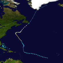
Hurricane Erin was the longest-lived hurricane in the 2001 Atlantic hurricane season. The sixth tropical depression, fifth tropical storm, and first hurricane, Erin developed from a tropical wave on September 1. After strengthening to a 60 mph (95 km/h) tropical storm as it moved to the west-northwest, wind shear weakened Erin and caused it to dissipate on September 5. The remnants re-organized into a tropical depression the next day, and Erin strengthened into a hurricane on September 9 while moving northwestward. This was the latest date for the first hurricane of the season since Hurricane Diana on September 10, 1984.[1] Erin quickly intensified and reached peak winds of 120 mph (195 km/h) later on September 9. At its closest approach, Erin passed 105 miles (170 km) east-northeast of Bermuda near peak intensity, and subsequently weakened as it turned to the east. A trough turned Erin to the northeast, and after passing just east of Cape Race, Newfoundland it became extratropical on September 15. The extratropical remnant continued northeastward and lost its identity near Greenland on September 17.
Though it passed 105 miles (170 km) east of Bermuda, Hurricane Erin caused little damage or effects on the island. Large swells from the hurricane produced rough surf and rip currents along the East Coast of the United States. In Newfoundland, Erin dropped moderate amounts of rain and gusty winds, though no damage was reported. Throughout its path, Erin caused no casualties, no injuries, and minor damage.
Meteorological history
A tropical wave moved off the coast of Africa on August 30. It almost immediately displayed signs of tropical cyclone formation with the development of deep convection and curved rainbands. Organization continued, and late on August 30 Dvorak classifications began on the system.[2] On August 31, after passing well south of the Cape Verde islands, the system stopped its organization trend.[3] Convection became sporadic,[2] and the system became poorly organized as it moved westward at 20 mph (32 km). However, environmental conditions remained favorable.[4] On September 1, the cloud pattern became better organized, and a low-level circulation quickly developed.[2] Following an increase in convection and conformation of a low-level circulation by a buoy, it is estimated the system developed into Tropical Depression Six late on September 1 while located 1,600 miles (2,590 km) east of the Lesser Antilles.[5]
Located to the south of a mid-level ridge, the depression moved to the west-northwest. With weak to moderate upper-level wind shear over the system, the depression gradually organized, and intensified into Tropical Storm Erin on September 2.[2] Though Erin had favorable upper-level outflow and developing convection, the inner core of the storm remained disorganized.[6] The storm slowly strengthened, and attained an initial peak intensity of 60 mph (95 km/h) while located about 1,150 miles (1,855 km) east of the Lesser Antilles. Favorable conditions were expected to allow Erin to continue to strengthen to reach winds of 85 mph (135 km/h).[7] However, an upper-level low to the northwest of Erin produced strong vertical shear over the storm, and Erin quickly weakened as the low-level circulation became exposed to the southwest of the deep convection. The shear slightly abated on September 4, allowing Erin to briefly re-strengthen. However, the storm remained disorganized, and following an increase in southwesterly wind shear Erin began a weakening trend. On September 5, Erin weakened to a tropical depression, and hours later the low-level circulation dissipated.[2]

The remnant low pressure area continued to the west-northwest,[8] and on September 6 the system gradually produced deep convection.[9] A surface circulation redeveloped in the northern portion of the remnants of Erin, and the system developed into a tropical depression again late on September 6 while located 365 miles (585 km) north-northwest of where it previously dissipated. The depression moved to the north-northeast, then turned to the north-northwest, and regained tropical storm status on September 7. Erin steadily intensified,[2] and its convection and cloud pattern became much better organized on September 8.[10] On September 9 Erin intensified into a hurricane while located 275 miles (440 km),[2] and a 40 mile (65 km) wide eye developed.[11] Erin quickly strengthened on September 9 to reach a peak intensity of 120 mph (195 km/h).,[2] however some sources claim that Erin may have been a little stronger.
Shortly after reaching its peak intensity, Erin passed 105 miles (170 km) east-northeast of Bermuda, its closest approach to the island. The hurricane maintained peak strength for 18 hours before slowly weakening. Its weakening trend was slower than usual due to warmer than usual water temperatures, and by late on September 10 Erin weakened to a Category 2 hurricane. Multiple short-wave troughs weakened the western portion of the subtropical ridge, and on September 11 Erin decelerated as it turned to the east. A strengthening mid- to upper-level trough over eastern Canada turned the hurricane to the northeast. It gradually accelerated its forward motion, and on September 15, after weakening to a strong tropical storm, Erin passed just east of Cape Race, Newfoundland.[2] Convection gradually diminished as it moved through the north Atlantic Ocean,[12] and later on September 15 Erin became extratropical. The extratropical storm continued northeastward, and after crossing over southern Greenland Erin merged with a high-latitude cyclonic flow to the east of Greenland on September 17.[2]
Impact and preparations

When the hurricane appeared to pose a threat to Bermuda, its government issued a hurricane watch. Around 24 hours before Erin made its closest approach, the watch was upgraded to a hurricane warning.[2] Initial forecasts indicated Erin would pass within 15 miles (24 km) of the island. As a result, ferry and bus transport was suspended. Officials prepared a school to be used as an emergency shelter, though few people used it.[13] The threat of the hurricane cancelled several flights in and out of the Bermuda International Airport,[14] stranding hundreds of travellers. Cruise ships and cargo ships also cancelled or delayed their arrivals.[15] The strongest winds of Erin remained to the east of the island. As a result, the highest winds on the island peaked at 41 mph (66 km/h).[2] Moderate winds downed several trees onto power lines,[14] leaving dozens of homes without power for several hours.[15] Prolonged durations of strong waves resulted in coastal beach erosion.[16] Large waves broke a boat from its moorings, though two men swam through the rough seas to prevent the yacht from running aground. The storm produced rainfall on the island, yet no flooding was reported.[15] Little structural damage occurred on Bermuda, and there were no reported injuries or casualties.[16]
Swells from Erin produced rip currents along the North Carolina coastline. Waves were expected to reach over 6 feet (1.8 m) in height.[17] Officials at the National Hurricane Center cautioned authorities and residents to monitor the rough seas.[14]
Erin produced moderate winds across Newfoundland, including a maximum sustained wind report of 53 mph (85 km/h) with a gust of 67 mph (108 km/h) at Cape Race. The storm also produced moderate amounts of precipitation, peaking at 5.1 inches (131 mm) at Sagona Island.[2] Along the coast, the passage of the storm led to wave heights of up to 30 feet (9.3 m), while offshore a buoy recorded a wave height of 47 feet (14.2 m). No damage was reported in Canada.[18]
This storm is also notable for passing near New York City on the day of the September 11 Attacks. The storm ended up staying well offshore.
See also
References
- ↑ Hurricane Research Division (2006). "Hurdat Data for Tropical Cyclones 1851-2005". NOAA. Archived from the original on July 5, 2006. Retrieved 2006-11-06.
- 1 2 3 4 5 6 7 8 9 10 11 12 13 Richard Pasch & Daniel Brown (2002-01-25). "Hurricane Erin Tropical Cyclone Report" (PDF). National Hurricane Center. Retrieved 2011-12-04.
- ↑ Lixion Avila and Robert Molleda (2001-08-30). "August 30 Tropical Weather Outlook". National Hurricane Center. Retrieved 2011-12-04.
- ↑ Jack Beven (2001-08-31). "August 31 Tropical Weather Outlook". National Hurricane Center. Retrieved 2011-12-04.
- ↑ Miles Lawrence (2001-09-01). "Tropical Depression Six Discussion One". National Hurricane Center. Retrieved 2011-12-04.
- ↑ Richard Pasch (2001-09-03). "Tropical Storm Erin Discussion Six". National Hurricane Center. Retrieved 2011-12-04.
- ↑ Stacy Stewart (2001-09-03). "Tropical Storm Erin Discussion Seven". National Hurricane Center. Retrieved 2011-12-04.
- ↑ Richard Pasch and Jamie Rhome (2001-09-05). "September 5 Tropical Weather Outlook". National Hurricane Center. Retrieved 2011-12-04.
- ↑ Stacy Stewart (2001-09-06). "September 6 Tropical Weather Outlook". National Hurricane Center. Retrieved 2011-12-04.
- ↑ Lixion Avila (2001-09-08). "Tropical Storm Erin Discussion Twenty-Five". National Hurricane Center. Retrieved 2011-12-04.
- ↑ Jack Beven (2001-09-08). "Hurricane Erin Discussion Twenty-Seven". National Hurricane Center. Retrieved 2011-12-04.
- ↑ Brian Jarvinen (2001-09-15). "Tropical Storm Erin Discussion Fifty-One". National Hurricane Center. Retrieved 2001-12-04.
- ↑ Matthew Taylor (2001). "Hurricane Erin Spares Bermuda". Associated Press.
- 1 2 3 Associated Press (2001). "Weakening Hurricane Erin spawns strong waves along East Coast". CNN. Archived from the original on July 20, 2007. Retrieved 2006-11-06.
- 1 2 3 Associated Press (2001-09-10). "Erin brushes past Bermuda, heads out to sea".
- 1 2 Roger Williams (2003-06-10). "Bermuda hurricanes since 1899". The Royal Gazette. Retrieved 2006-11-06.
- ↑ National Weather Service (2001). "Hurricane Erin Weather Statement". Archived from the original on September 28, 2007. Retrieved 2006-11-06.
- ↑ Canadian Hurricane Centre (2001). "2001 Tropical Cyclone Season Summary". Retrieved 2006-11-06.
External links
| Wikimedia Commons has media related to Hurricane Erin (2001). |
Tropical cyclones of the 2001 Atlantic hurricane season | ||
|---|---|---|
 | ||
| ||