Hurricane Erin (1995)
| Category 2 hurricane (SSHWS/NWS) | |
 Hurricane Erin hitting Florida Panhandle | |
| Formed | July 31, 1995 |
|---|---|
| Dissipated | August 6, 1995 |
| Highest winds |
1-minute sustained: 100 mph (155 km/h) |
| Lowest pressure | 973 mbar (hPa); 28.73 inHg |
| Fatalities | 6 direct; 7 indirect[1][2][3] |
| Damage | $700 million (1995 USD) |
| Areas affected | Bahamas, Florida, Alabama, Mississippi, Jamaica |
| Part of the 1995 Atlantic hurricane season | |
Hurricane Erin was the fifth named tropical cyclone and the second hurricane of the unusually active 1995 Atlantic hurricane season. Erin began as a tropical wave off the west coast of Africa on July 22, but the storm crossed most of the Atlantic ocean without developing. On July 31, it developed a closed circulation and became Tropical Storm Erin. It made landfall on the central eastern Florida coastline as a Category 1 hurricane on August 2 and again along the Florida Panhandle as a Category 2 hurricane on August 3, causing a moderate amount of damage. The system reached its peak strength of 100 mph (155 km/h) and 973 millibars in central pressure just prior to the second landfall.[3]
Hurricane and tropical storm warnings and watches were issued for both coasts of Florida prior to Erin's two landfalls. Tornado and flood watches and warnings were also issued for these areas as a preparation for the impacts from Erin.
The total monetary damage estimate in the United States from Erin is $700 million (1995 USD). The monetary damages from the system primarily came from downed trees, crop damages, and ship damages. There was various other damages that also occurred as a result of Erin.[3][4] Erin was the first hurricane to hit the U.S. since Hurricane Andrew in 1992.
Meteorological history

On July 22, a tropical wave emerged into the eastern Atlantic Ocean, off the western coast of Africa. It moved westerly or west-northwesterly through most of its life due to the influence of the Bermuda High and a second high pressure over the Mid Atlantic states. The system had two distinct low-level circulation centers, and a large area of convection. By July 27, both circulations were generating deep convection a few hundred miles to the northeast of the Leeward Islands. These centers began to exhibit sustained winds of around 30 mph (50 km/h) on July 28, but there was not a completely closed circulation needed to become a Tropical Depression.[3]
Near midday on July 30, as T-number estimates reached 2.5 (indicative of tropical storm strength), the National Hurricane Center decided to fly a special night reconnaissance mission into the system. This was ordered because of to the systems close range to the Bahamas and the state of Florida. At midnight on the start of July 31, Hurricane Hunter aircraft data showed that the storm had acquired a closed circulation. The system was therefore initiated as a Tropical Storm at 00Z July 31.[3]

Erin continued to develop slowly, persistently hindered by moderate wind shear. A weak upper-level low over southern Florida and western Cuba helped guide Erin onto a more northwesterly track. This directed Erin across the more heavily populated northern Bahamas and caused the storm to affect central Florida instead of south Florida. By the evening of the July 31, Erin was upgraded to a hurricane. The next day, an eye began to become apparent on satellite imagery. Early in the day on August 2, at approximately 2:15 AM local time, Erin made landfall in Vero Beach, Florida with winds around 85 mph (140 km/h).[3]
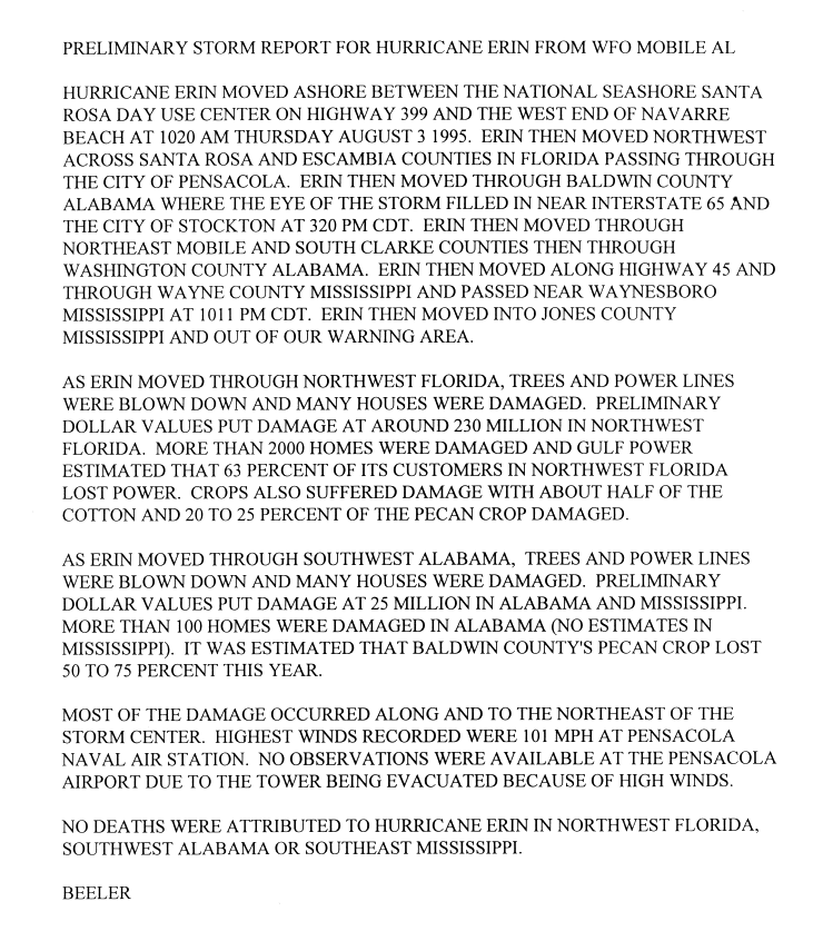
Erin's resumed a more west-northwest motion as it crossed the Florida peninsula during the morning and early afternoon of August 2. Erin also weakened to a tropical storm with 60 mph (95 km/h) winds, but remained fairly well-organized, despite losing its visible eye. Upon emerging into the eastern Gulf of Mexico, Erin reintensified to a hurricane and continued strengthening until landfall in the Florida Panhandle during the morning of August 3. Erin had maximum sustained winds around 100 mph (160 km/h) in a small area within its northeastern eyewall when coming ashore near Fort Walton Beach, Florida at 8:30 AM CDT, making it a Category 2 hurricane at landfall.[3] Erin then skirted the coast, making final landfall in Pensacola as an 85 mph hurricane at 11:00 AM central time.
Erin weakened to a tropical storm over southeastern Mississippi later on August 3. It then weakened to a tropical depression over central Mississippi overnight into August 4. The storm then merged with a frontal system over West Virginia during the following day.[3][4]
Preparations
Florida
A hurricane warning was issued for the southeastern Atlantic coast of Florida at 11 AM July 31, then extended north to New Smyrna Beach along with Lake Okeechobee on the morning of August 1. There were also tropical storm warnings issued from New Smyrna Beach northward to St. Augustine. A flood watch and high wind watch were issued for all of East-Central Florida. A tornado watch was also issued for East-Central Florida for the early stages of Erin.[5]
Many people on the east coast were wary of Erin because of the impact of Hurricane Andrew on the southern suburbs of Miami three years earlier.[6] Evacuations were initially posted for 800,000 people in Florida in preparation for the storm. As the storm moved further north, the evacuation order was reduced to only 400,000 people.[6] Local banks, universities, and shopping malls closed their doors.[6] Police were sent patrolling to prevent looting. About 300 military aircraft in the Florida Panhandle, were evacuated to neighboring states.[1]
NASA had to halt some activities, and rolled back Space Shuttle Endeavour back to the Vehicle Assembly Building from launchpad at Kennedy Space Center due to Erin.[7]
Watches and warnings were also issued ahead of the storm for the west coast of Florida. Most of the west coast was covered by a hurricane watch as of 11 PM EDT July 31. By the afternoon of August 1, tropical storm warnings were issued from 5 PM EDT on August 1 from Fort Myers to the mouth of the Suwannee River.
The entire Florida Panhandle was put under a tropical storm warning by 11 AM EDT August. The advisories were upgraded to hurricane warnings by 3 PM as the storm remained organized and targeted further west in the Panhandle.[3]
Alabama-Mississippi
A tropical storm watch was issued for Gulf Coast on the morning of August 2, and was upgraded at 3 PM to place the entire Alabama and Mississippi Gulf Coast under hurricane warning.[3]
In Alabama, Dauphin Island and low lying areas of Mobile County underwent voluntary evacuation. Alabama opened shelters to house evacuees.[1][3]
Louisiana
9,000 residents underwent mandatory evacuation in southeastern Louisiana. A state of emergency was issued to prepare for Erin.[1] A hurricane watch was issued on August 2 for the area between the mouth of the Pearl River and the mouth of the Mississippi River, including the city of New Orleans. As the storm continued to shift west, this was upgraded to a hurricane warning and extended as far west as Morgan City by midnight August 3. However, as the storm turned inland over the Florida panhandle, all hurricane warnings were discontinued by the that afternoon.[3]
Impact
Widespread tree downings, power line, crop, and roof damage was reported throughout the Southeastern United States.[8]

Jamaica
During heavy rains in the far outer bands of Erin hit, a plane crash killing 5 people. The plane was a Cessna 310 twin-engine aircraft, owned by RegionAir. The aircraft contained four employees of Brinks Jamaica, who were due to testify in a court hearing, and a pilot. The plane departed from the Tinson Pen Aerodrome in Kingston, Jamaica, and was bound for Montego Bay, St. James. Two teenagers were also killed on a football field in Braeton, Saint Catherine Parish, when lightning associated with Erin struck them.[2][9]
Northwest Caribbean
| Precipitation | Storm | Location | Ref. | ||
|---|---|---|---|---|---|
| Rank | mm | in | |||
| 1 | 747.5 | 29.43 | Noel 2007 | Long Island | [10] |
| 2 | 436.6 | 17.19 | Flora 1963 | Duncan Town | [11] |
| 3 | 390.1 | 15.36 | Inez 1966 | Nassau Airport | [11] |
| 4 | 337.1 | 13.27 | Fox 1952 | New Providence | [11] |
| 5 | 321.1 | 12.64 | Michelle 2001 | Nassau | [12] |
| 6 | 309.4 | 12.18 | Erin 1995 | Church Grove | [13] |
| 7 | 260.0 | 9.88 | Fay 2008 | Freeport | [14] |
| 8 | 236.7 | 9.32 | Floyd 1999 | Little Harbor Abacos | [15] |
| 9 | 216.4 | 8.52 | Cleo 1964 | West End | [11] |
| 10 | 207.0 | 8.15 | Betsy 1965 | Green Turtle Cay | [11] |
All of the Bahamian islands sustained damage, characterized by the Bahamas Department of Meteorology as mostly minor. Much of the damage came from sunken boats. Some of the other losses resulted from structural damage and crop loss. Damage totaled at least $400,000 (1995 USD).[3]
The highest sustained wind in the Bahamas was 70 knots at Cat Island. A gust of 89 knots was reported in Grand Bahama, and a gust of 128 knots in association with a tornado occurred at Providenciales in the Turks and Caicos Islands.[16] Hurricane-force sustained winds were experienced over various portions of the Bahamas.[3] Heavy rainfall was also reported.[17]
Florida
Erin caused six drowning deaths off the coasts of Florida. The cruise ship Club Royale sank, causing three of the deaths. A surfer died in Palm Beach County and two others were swept out to sea at Cape San Blas. More than one million people lost power due to the hurricane. Erin caused $700 million (1995 US dollars) in damage, mostly in Florida. Moderate beach erosion was reported along Florida's east coast and Panhandle.[1][3][18]
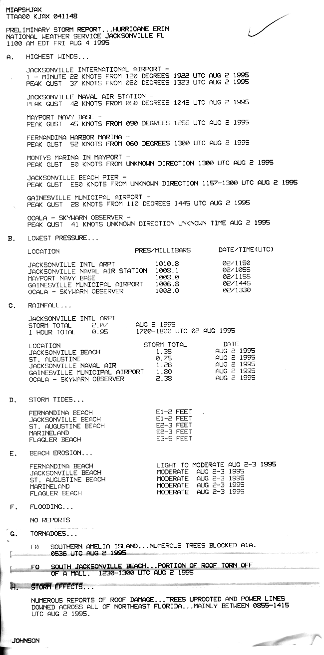
Multiple waterspouts and tornadoes were reported throughout the state. A tornado in Titusville, caused minor damage. Another tornado, near Lake Lizzie, killed two horses. Trees also went down and roofs were blown off houses.[19][1][3][18] A tornado in southern Amelia Island resulted in trees blocking route A1A. A portion of a roof was torn off a mall in south Jacksonville Beach as a result of a tornado.[8] Another tornado was reported at Hurlburt Field.
Two to four foot storm surge was reported on Florida's east coast during Erin's first landfall. One to two foot storm surge was reported on Florida's West-Central coast. Six to seven feet storm surge were estimated west of Navarre Beach, and three to four foot storm surge was reported along Pensacola Beach.[3]
Flooding was also reported in parts of east-central Florida, with rainfall of over 10 inches near Erin's landfall location. Lanes of Interstate 95 were flooded, and some locations remained flooded days after the storm.[20]
NASA recorded a peak wind gust of 82 mph, directed from the east-southeast, from a wind tower at the Kennedy Space Center.[7]
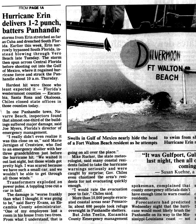
The most significant damage from the second landfall in Florida was near Pensacola, where Erin made landfall, and Navarre Beach, where almost one-third of buildings suffered major damage.[21] A maximum wind of 101 mph was reported at Pensacola Naval Air Station. The tower of Pensacola Airport was evacuated due to high winds, and the data is therefore unavailable. More than 2,000 homes were reported damaged from Erin. Some beach erosion was also reported west of Navarre Beach.[3] There was a large amount of crop losses in Northwest Florida resulting from Erin. This included about half of the cotton crop of the region and around 20 to 25 percent of the pecan crop. An estimated amount of 63 percent of power customers in Northwest Florida were left without power from the hurricane.[22]
The Federal Emergency Management Agency (FEMA) issued a federal disaster declaration for Florida due to Erin.[23]
Alabama
The American Insurance Services Group estimated that there was $20 million of damage in Alabama, which is estimated by the National Hurricane Center to represent half of the total damage in the state.[3]
Tropical storm forced gusts were reported in the Mobile area, and trees and power lines were blown down throughout southwest Alabama. At least 100 homes were reported damaged in Alabama. The estimated pecan crop for Baldwin County, Alabama suffered losses estimated at 50 to 75 percent of the total crop.[22]
Mississippi
The American Services Group estimated that there was $5 million of damage in Mississippi, which is estimated at half of the total damage by the National Hurricane Center.[3]
A book reported that hurricane winds of 90 mph were reported in Jackson, Mississippi[20]
There are no reports of the total amount of houses damaged in Mississippi.[22]
Georgia
Minimal damage was experienced in Georgia. Some beach erosion was reported through portions of the state.[1][3][18]
See also
- Other storms of the same name
- Timeline of the 1995 Atlantic hurricane season
- List of North Carolina hurricanes (1980–present)
- List of Florida hurricanes
- video of Hurricane Erin
References
- 1 2 3 4 5 6 7 (Associated Press via the Syracuse Herald Journal)
- 1 2 (The Gleaner)
- 1 2 3 4 5 6 7 8 9 10 11 12 13 14 15 16 17 18 19 20 21 Rappaport, Edward (2016-11-29). "Hurricane Erin Preliminary Report" (PDF). National Hurricane Center. Retrieved 2011-10-05.
- 1 2 Roth, David (2007-08-30). "Hurricane Erin - August 1-7, 1995". Hydrometeorological Prediction Center. Retrieved 2011-10-05.
- ↑ (Hurricane Local Statement 836 PM)
- 1 2 3 Clary, Mike (August 2, 1995). "HURRICANE ERIN SLAMS INTO FLORIDA // Storm Strikes Land North of Palm Beach". Chicago Sun-Times. Retrieved 1 April 2014.
- 1 2 (NASA Data)
- 1 2 (Pshjax NOAA Archive)
- ↑ (Associated Press via The Post Standard)
- ↑ Brown, Daniel P (December 17, 2007). Tropical Cyclone Report: Hurricane Noel 2007 (PDF) (Technical report). United States National Hurricane Center. p. 4. Retrieved April 25, 2016.
- 1 2 3 4 5 Roth, David M. (April 29, 2015). "Tropical Cyclone Point Maxima". Tropical Cyclone Rainfall Data. United States Weather Prediction Center. Retrieved May 8, 2016.
- ↑ Beven III, John L; National Hurricane Center (January 23, 2002). Hurricane Michelle 2001 (Tropical Cyclone Report). United States National Oceanic and Atmospheric Administration's National Weather Service. Retrieved June 10, 2012.
- ↑ Rappaport, Edward N; National Hurricane Center (November 26, 1995). Hurricane Erin 1995 (Preliminary Report). United States National Oceanic and Atmospheric Administration's National Weather Service. Retrieved June 10, 2012.
- ↑ Beven III, John L; Stewart, Stacey R; National Hurricane Center (February 8, 2009). Tropical Storm Fay 2008 (PDF) (Tropical Cyclone Report). United States National Oceanic and Atmospheric Administration's National Weather Service. Retrieved June 10, 2012.
- ↑ Pasch, Richard J; Kimberlain, Todd B; Stewart, Stacey R; National Hurricane Center (November 18, 1999). Hurricane Floyd 1999 (Preliminary Report). United States National Oceanic and Atmospheric Administration's National Weather Service. Retrieved June 10, 2012.
- ↑ http://journals.ametsoc.org/doi/full/10.1175/1520-0493(1998)126%3C1124%3AAHSO%3E2.0.CO%3B2
- ↑ http://www.thenassauguardian.com/index.php?option=com_content&view=article&id=40267:the-wettest-hurricanes-to-drench-the-bahamas&catid=84:hurricane
- 1 2 3 (Tracking the Tropics Summary of Erin)
- ↑ http://journals.ametsoc.org/doi/full/10.1175/1520-0493(1998)126%3C1124%3AAHSO%3E2.0.CO%3B2>
- 1 2 (Florida Hurricanes and Tropical Storms)
- ↑ (NOAA Newspaper Archive ss0804p2)
- 1 2 3 (NOAA Mobile Preloc Archive)
- ↑ (Federal Disaster Declarations 1995)
External links
| Wikimedia Commons has media related to Hurricane Erin (1995). |
Tropical cyclones of the 1995 Atlantic hurricane season | ||
|---|---|---|
 | ||
| ||