Hurricane Dean (1989)
| Category 2 hurricane (SSHWS/NWS) | |
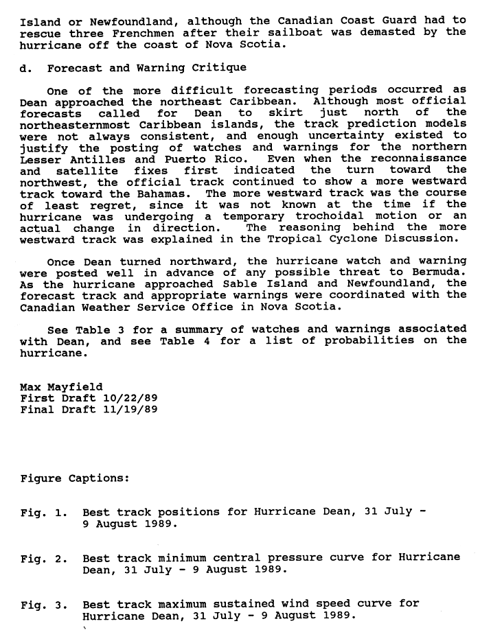
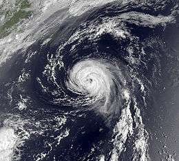 Hurricane Dean nearing Atlantic Canada | |
| Formed | July 31, 1989 |
|---|---|
| Dissipated | August 9, 1989 |
| Highest winds |
1-minute sustained: 105 mph (165 km/h) |
| Lowest pressure | 968 mbar (hPa); 28.59 inHg |
| Fatalities | None reported |
| Damage | $8.9 million (1989 USD) |
| Areas affected | Virgin Islands, Puerto Rico, Bermuda, Atlantic Canada |
| Part of the 1989 Atlantic hurricane season | |
Hurricane Dean was the fourth named storm and second hurricane of the 1989 Atlantic hurricane season. Dean formed on July 31 and reached tropical storm status the following day east of the Leeward Islands. Dean brushed the northern Leeward Islands as a Category 1 hurricane on the Saffir–Simpson Hurricane Scale, bringing light rain but producing no damage, before turning northward and striking Bermuda as a Category 2 hurricane. Dean continued northward before making landfall in southeastern Newfoundland.
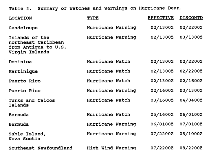
Since Dean was initially difficult to forecast, it posed a possible threat to the Lesser Antilles, as a result, several evacuations occurred, and many hurricane watches and warning were issued. However, as Dean turned northward, all watches and warnings in the Lesser Antilles were discontinued. As Dean approached Bermuda, a hurricane watch was issued, and was later upgraded to a hurricane warning. After Dean tracked away from the island, the hurricane warning was discontinued. In addition, a hurricane warning was briefly in effect for Sable Island, Nova Scotia. The storm left $8.9 million (1989 USD, $17 million 2016 USD) and sixteen injuries across Bermuda, but no fatalities were reported. In Atlantic Canada, Dean dropped light rain across Nova Scotia and Sable Island.
Meteorological history

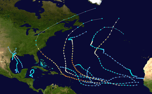
A tropical wave moved off the coast of Africa on July 27 as detected by Meteosat imagery. By July 31 the tropical wave began being classified, using the Dvorak Technique, by satellite analysts at the National Hurricane Center, in part due to persistent deep convection. Shortly thereafter the system organized enough that the National Hurricane Center began classifying it as Tropical Depression Five, roughly halfway between Cape Verde and the Lesser Antilles. The depression moved westward at 17 mph (28 km/h), intensifying as it did so, and eventually intensified enough to be upgraded to a tropical storm, which was named Dean by the National Hurricane Center.[1]
Continuing generally westward, Dean continued to gradually intensify and became a hurricane on August 2 after an Air Force reconnaissance flight had recorded hurricane-force winds. The following day a decreasing ridge of high pressure to the north and a trough of low pressure forming off the East Coast of the United States caused Dean to slow in its forward motion and turn northwest. The trough of low pressure forming off the East Coast of the United States was deepening, causing Dean to curve northward while remaining nearly stationary. After remaining nearly stationary, Dean began to accelerate to a forward speed of 17 mph (28 km/h) as it headed toward Bermuda. Thereafter, Dean intensified into a Category 2 hurricane, whilst the eastern half of the eyewall brushed Bermuda. Dean continued to intensify slightly after passing the island of Bermuda and became a Category 2 hurricane on August 7. While Dean was a Category 2 hurricane, it attained its peak intensity with winds of 105 mph (165 km/h) and a minimum pressure of 968 mbar (hPa; 28.59 inHg).[1]
After peak intensity, the forward speed of Dean continued to increase as it approached Atlantic Canada while weakening back to a Category 1 hurricane. While approaching southern Newfoundland, Dean had weakened enough to be downgraded to a tropical storm on August 8. Shortly thereafter, Dean then made landfall on the south coast of Newfoundland with winds of 65 mph (105 km/h). Later that day, Dean emerged into the far north Atlantic and rapidly transitioned into an extratropical cyclone on the following day.[1]
Preparations
Hurricane Dean was very difficult to forecast in its early stages as the storm approached the eastern Caribbean. Even though most forecast models predicted that Dean would skirt the Leeward Islands, the track prediction models were not consistent and, as a result, uncertainty existed in justifying the posting of watches and warnings for the Leeward Islands and Puerto Rico. One track predicted Dean to threaten South Florida within three to four days.[2]
Regardless, the National Hurricane Center issued hurricane warnings for Guadeloupe on August 2 and the rest of the Leeward Islands extending to the Virgin Islands. The uncertainty of the hurricanes forecast track forced residents and tourists in the Lesser Antilles to evacuate. In the British Virgin Islands, 80 American and Canadian tourists evacuated to hotels. In Puerto Rico, residents were advised to secure or stow away loose objects and stock up on emergency supplies. 1.1 million residents in the city of San Juan went to supermarkets to get much needed supplies in anticipation that the storm might hit Puerto Rico. In Humacao, the National Guard evacuated 1,966 people living along a coastal highway.[3] The islands of Martinique and Dominica were placed under a hurricane watch. The warning for Guadeloupe was discontinued at 2200 UTC when the hurricane posed no threat to the island. Simultaneously, the hurricane watches in effect for Martinique and Dominica were also discontinued. As Dean continued westward, the National Hurricane Center issued a hurricane watch for the Turks and Caicos Islands. The watch was soon canceled as Dean made its northward turn towards Bermuda.[4][5]
In Bermuda, the National Hurricane Center issued a hurricane watch on August 5. The hurricane watch was later changed to a hurricane warning the following day. Dean’s approach to the island canceled numerous inbound and outbound flights. In Atlantic Canada, the National Hurricane Center issued a hurricane warning for Nova Scotia and Sable Island, while the Canadian forecasters issued a high wind advisory.[5][6]
Impact
The outer bands of Hurricane Dean produced heavy rainfall and winds up to 75 mph (121 km/h) across Antigua and Barbuda. There was no reported damage in the Leeward Islands or the Virgin Islands since the hurricane turned northward. In the Atlantic, a sailboat bound for Bermuda was caught off guard by the hurricane. The boat, which carried no radio equipment, was spotted by a hurricane hunter plane. The occupants of the boat suffered no injuries. In Bermuda, the hurricanes eastern eyewall produced 81 mph (130 km/h) sustained winds with gusts up to 113 mph (182 km/h). Bermuda highest rainfall total from Dean was 2.45 in (50.8 mm) while parts of the island received 3-5 in (76.2–127 mm) of rain.[6][7][8]
Strong winds from Hurricane Dean caused considerable power line damage, leaving 65,000 residents without electricity. The winds also caused minor roof damage. In Hamilton Harbor, 20 pleasure boats were damaged or sent adrift due to the rough seas. Flooding from the hurricane damaged fifteen houses. Sixteen people were injured by the hurricane, five of the injuries were considered serious. There were, however, no reports of fatalities from Dean’s impact on Bermuda. Damage in Bermuda amounted up to $8.9 million (1989 USD, $17 million 2016 USD).[6][8]
Although Dean remained away from the United States coastline, it produced storm tides of 1.7 ft (0.51 m) to North Carolina. In Atlantic Canada, hurricane-force winds were reported in Nova Scotia and Sable Island. Newfoundland reported winds of only 50 mph (80 km/h). Moderate rainfall was reported on Newfoundland, with most areas of the island experiencing at least 1 in (25.4 mm) of precipitation. Rainfall on Newfoundland peaked at 2.7 in (68.58 mm) on the south coast of the island, near the location of Dean's landfall. A majority of rainfall was reported on the west side of Dean, but minimal precipitation had been recorded to the east of the storm. High winds were reported on the eastern side of the storm, however, with lighter winds along the western quadrants of Dean. Offshore, waves up to 26 ft (7.92 m) were reported and Sable Island reported rainfall of 0.59 in (15 mm). Although there were no reports of damage in Atlantic Canada from Hurricane Dean, three sailors had to be rescued by the Canadian Coast Guard when their boat got dismasted during the storm.[4][8][9][10]
See also
References
- 1 2 3 Mayfield, Max (1989-11-19). "Hurricane Dean Preliminary Report, Page 1". National Hurricane Center. Retrieved 2011-03-01.
- ↑ Associated Press (1989). "Dean Develops into a Hurricane". The News.
- ↑ Associated Press (1989). "Hurricane Veers Away from Puerto Rico, Virgin Islands". The News.
- 1 2 Mayfield, Max (1989-11-19). "Hurricane Dean Preliminary Report, Page 3". National Hurricane Center. Retrieved 2011-03-01.
- 1 2 Mayfield, Max (1989-11-19). "Hurricane Dean Preliminary Report, Page 9". National Hurricane Center. Retrieved 2011-03-01.
- 1 2 3 Associated Press (1989). "Bermuda Escapes the wrath of Dean".
- ↑ Reuters (1989). "Islanders scramble to safety from hurricane". Daily Herald.
- 1 2 3 Max, Mayfield (1989-11-19). "Hurricane Dean Preliminary Report, Page 2". National Hurricane Center. Retrieved 2011-03-01.
- ↑ Associated Press (1989). "Hurricane sweeps past Nova Scotia". Syracuse Herald Journal.
- ↑ Environment Canada (2010-09-14). "1989-Dean". Retrieved 2011-03-01.
Tropical cyclones of the 1989 Atlantic hurricane season | ||
|---|---|---|
 | ||
| ||