Hurricane Danielle (2004)
| Category 2 hurricane (SSHWS/NWS) | |
 Hurricane Danielle at peak intensity in the open Atlantic | |
| Formed | August 13, 2004 |
|---|---|
| Dissipated | August 21, 2004 |
| Highest winds |
1-minute sustained: 110 mph (175 km/h) |
| Lowest pressure | 964 mbar (hPa); 28.47 inHg |
| Fatalities | None |
| Damage | None |
| Areas affected | No land areas |
| Part of the 2004 Atlantic hurricane season | |
Hurricane Danielle was the first of several Cape Verde-type hurricane to form during the 2004 Atlantic hurricane season. Danielle was the fourth named storm and third hurricane of the season. Danielle formed on August 13, 2004 in the far eastern Atlantic Ocean and remained over the central Atlantic, peaking as a strong Category 2 hurricane on August 16 before weakening over cooler waters; becoming a remnant low on August 21 and dissipating on August 24. Danielle never approached land, although it briefly threatened the Azores as it made the northerly turn. As a result, there was no impact caused by the storm.
Meteorological history
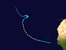
Hurricane Danielle began as a vigorous tropical wave over Africa. As the wave emerged into the Atlantic, it quickly became more organized due to favorable conditions, including low wind shear. The circulation consolidated and spawned Tropical Depression Four on the morning of August 13 south-southeast of the Cape Verde islands.[1] The system was over somewhat cooler water at first with sea surface temperatures around 79°F (26°C);[2] however, the low shear environment allowed the depression to continue to organize. Late that evening, the system strengthened into Tropical Storm Danielle.[1]
As Danielle tracked westward into the open Atlantic early on August 14, the storm encountered warmer water southwest of Cape Verde and began to gradually intensify, becoming a moderate tropical storm with 50 mph (85 km/h) winds that morning. At that point, a bout of rapid intensification began to take place, and the storm was upgraded to Hurricane Danielle that evening as an eye began to form.[3] Over a 24‑hour period ending in the morning of August 15, the pressure fell from 1004 to 978 mbar and the winds increased to 90 mph (145 km/h), making it a high-end Category 1 hurricane on the Saffir-Simpson hurricane scale.[4]
Danielle levelled off somewhat in intensity after that round of rapid intensification, only gradually strengthening afterward due to structural changes in the storm related to the small wind field relative to the size of the eye.[1] Nonetheless, Danielle became a Category 2 hurricane on the afternoon of August 15 as it approached the subtropical ridge which blocked the continued westward movement. Beginning late on August 15, at about 35°W, Danielle began to recurve to the northwest and eventually north while continuing to gradually strengthen.[1] Early on August 16, the recurvature became more pronounced, and Danielle turned abruptly northward in the central Atlantic Ocean as an upper-level trough opened up a large break in the ridge.[5] That movement took it along the eastern side of the subtropical ridge, preventing Danielle from moving any farther west and becoming any threat to North America or the Caribbean.[4] While moving northwest, Danielle strengthened a bit more, reaching its peak intensity of 110 mph (175 km/h), just under Category 3 intensity, on the afternoon of August 16.[1]

The northward movement also sent Danielle into somewhat increased shear, which allowed it to begin to weaken. However, the weakening was gradual at first as the waters remained fairly warm. The abrupt northerly turn meant that, for a while on August 17, the Azores were threatened by Danielle in the long-range forecast, as a weakened tropical storm or extratropical cyclone.[6] Danielle weakened to a Category 1 hurricane on the evening of August 17 as shear continued to increase.[1] Danielle began to turn to the northeast early on August 18, and at that point, the weakening trend accelerated. Some of the deep convection was being removed from the system due to wind shear,[4] and that morning, Danielle weakened to a tropical storm. The rapid weakening trend continued that afternoon, and Danielle weakened to a low-end tropical storm with 45 mph (75 km/h) winds late that evening. However, the intensity levelled off early on August 19 and Danielle remained a tropical storm for the next couple days over moderately warm water of around 78°F (just under 26°C) while south-southwest of the Azores.[1]
Intermittent deep convection continued to fire up, keeping the storm afloat for the next day and turning it away from the Azores. Danielle also changed direction and meandered slightly to the northwest, away from the Azores, due to very weak steering currents.[7] After holding on as a minimal tropical storm, Danielle finally lost its deep convection due to high upper-level vertical shear[8] and was downgraded to a tropical depression on the afternoon of August 20.[1] The depression turned once again to the north, and continued to lose organization over cooler water. It degenerated into a remnant low on the afternoon of August 21 as the convection was completely sheared away from the center of Danielle.[9] The remnant low remained in the open ocean, remaining devoid of any deep convection, until August 24 when it dissipated west-southwest of the Azores.[1]
Impact, naming, and records
Hurricane Danielle did not have any impact on land and no damage or fatalities were reported. No ships were reported to have come into contact with Danielle.[1] When Danielle became a tropical storm at 24.8°W, it was the farthest east that a storm had received a name since Hurricane Alberto in the 2000 Atlantic hurricane season.[10]
See also
References
- 1 2 3 4 5 6 7 8 9 10 Stacy R. Stewart (November 19, 2004). "Tropical Cyclone Report: Hurricane Danielle" (PDF). National Hurricane Center. Retrieved October 26, 2006.
- ↑ Stewart (August 13, 2004). "Tropical Depression Four Discussion Two". National Hurricane Center. Retrieved October 26, 2006.
- ↑ Brown and Beven (August 14, 2004). "Tropical Storm Danielle Discussion Seven". National Hurricane Center. Retrieved October 26, 2006.
- 1 2 3 Staff Writer (2004). "Hurricane Danielle". NASA. Retrieved October 26, 2006.
- ↑ Stewart Sisko (August 16, 2004). "Hurricane Danielle Discussion Twelve". National Hurricane Center. Retrieved October 26, 2006.
- ↑ Franklin (August 17, 2004). "Hurricane Danielle Discussion Nineteen". National Hurricane Center. Retrieved October 26, 2006.
- ↑ Avila (August 19, 2004). "Tropical Storm Danielle Discussion Twenty-Five". National Hurricane Center. Retrieved October 26, 2006.
- ↑ Avila (August 20, 2004). "Tropical Depression Danielle Discussion Thirty". National Hurricane Center. Retrieved October 26, 2006.
- ↑ Avila (August 21, 2004). "Tropical Depression Danielle Discussion Thirty-Three". National Hurricane Center. Retrieved October 26, 2006.
- ↑ William M. Gray and Philip J. Klotzbach (November 19, 2004). "Summary of the 2004 Atlantic Tropical Cyclone Activity and Verification of Author's Seasonal and Monthly Forecasts". Colorado State University. Retrieved October 26, 2006.
External links
| Wikimedia Commons has media related to Hurricane Danielle (2004). |
- NHC's Tropical Cyclone Report on Hurricane Danielle
Tropical cyclones of the 2004 Atlantic hurricane season | ||
|---|---|---|
 | ||
| ||