Hunting Valley, Ohio
| Hunting Valley, Ohio | |
|---|---|
| Village | |
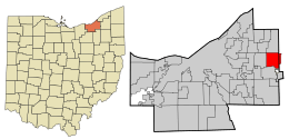 Location in Cuyahoga County and the state of Ohio. | |
| Coordinates: 41°28′34″N 81°24′4″W / 41.47611°N 81.40111°WCoordinates: 41°28′34″N 81°24′4″W / 41.47611°N 81.40111°W | |
| Country | United States |
| State | Ohio |
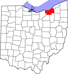
| Counties | Cuyahoga, Geauga |
| Area[1] | |
| • Total | 8.01 sq mi (20.75 km2) |
| • Land | 7.89 sq mi (20.44 km2) |
| • Water | 0.12 sq mi (0.31 km2) |
| Elevation[2] | 764 ft (233 m) |
| Population (2010)[3] | |
| • Total | 705 |
| • Estimate (2012[4]) | 709 |
| • Density | 89.4/sq mi (34.5/km2) |
| Time zone | Eastern (EST) (UTC-5) |
| • Summer (DST) | EDT (UTC-4) |
| ZIP code | 44022, 44040 |
| Area code(s) | 440, 216 |
| FIPS code | 39-36918[5] |
| GNIS feature ID | 1041884[2] |
| Website | http://www.huntingvalley.net/about.cfm/ |
Hunting Valley is a village located east of Cleveland in Cuyahoga and Geauga counties in the Northeast Ohio region, the 14th largest Combined Statistical Area in the United States. As of the 2010 census, the village population was 705.[6] At the 2000 census, it was ranked the 6th highest-income place in the United States.
History
Hunting Valley is one of the five municipalities, along with Moreland Hills, Orange Village, Pepper Pike and Woodmere, that originally formed Orange Township, established in 1820. Orange Township was the birthplace of President James A. Garfield in 1831. In 1924, Hunting Valley was incorporated as a village encompassing the northeast quadrant of the original Orange Township. Hunting Valley is also part of the Connecticut Western Reserve.
Geography
Hunting Valley is located at 41°28′34″N 81°24′04″W / 41.476019°N 81.401233°W (41.476019, -81.401233).[7]
According to the United States Census Bureau, the village has a total area of 8.01 square miles (20.75 km2), of which 7.89 square miles (20.44 km2) is land and 0.12 square miles (0.31 km2) is water.[1]
Demographics
| Historical population | |||
|---|---|---|---|
| Census | Pop. | %± | |
| 1930 | 401 | — | |
| 1940 | 374 | −6.7% | |
| 1950 | 477 | 27.5% | |
| 1960 | 629 | 31.9% | |
| 1970 | 797 | 26.7% | |
| 1980 | 786 | −1.4% | |
| 1990 | 799 | 1.7% | |
| 2000 | 735 | −8.0% | |
| 2010 | 705 | −4.1% | |
| Est. 2015 | 720 | [8] | 2.1% |
Hunting Valley is the wealthiest community in the state of Ohio and one of the most affluent in the United States, with an average household income of $373,181.[10]
2010 census
As of the census[3] of 2010, there were 705 people, 277 households, and 216 families residing in the village. The population density was 89.4 inhabitants per square mile (34.5/km2). There were 322 housing units at an average density of 40.8 per square mile (15.8/km2). The racial makeup of the village was 97.0% White, 0.6% African American, 1.1% Asian, 0.3% from other races, and 1.0% from two or more races. Hispanic or Latino of any race were 2.7% of the population.
There were 277 households of which 26.7% had children under the age of 18 living with them, 72.9% were married couples living together, 2.2% had a female householder with no husband present, 2.9% had a male householder with no wife present, and 22.0% were non-families. 19.9% of all households were made up of individuals and 12.3% had someone living alone who was 65 years of age or older. The average household size was 2.55 and the average family size was 2.90.
The median age in the village was 50.3 years. 23.1% of residents were under the age of 18; 5.8% were between the ages of 18 and 24; 11.4% were from 25 to 44; 33.5% were from 45 to 64; and 26.4% were 65 years of age or older. The gender makeup of the village was 49.2% male and 50.8% female.
2000 census
As of the census[5] of 2000, there were 735 people, 284 households, and 241 families residing in the village. The population density was 92.1 people per square mile (35.6/km2). Of the 735 people, 728 of them are white. There were 317 housing units at an average density of 39.7 per square mile (15.3/km2). The racial makeup of the village was 99.05% White, 0.14% African American, 0.68% Asian, and 0.14% from two or more races. Hispanic or Latino of any race were 0.54% of the population. 17.4% were of English, 17.1% German, 11.0% Irish, 9.0% Italian, 5.7% American and 5.6% Russian ancestry according to Census 2000.
There were 284 households out of which 27.8% had children under the age of 18 living with them, 77.8% were married couples living together, 4.9% had a female householder with no husband present, and 15.1% were non-families. 13.7% of all households were made up of individuals and 6.0% had someone living alone who was 65 years of age or older. The average household size was 2.59 and the average family size was 2.80.
In the village the population was spread out with 21.6% under the age of 18, 4.4% from 18 to 24, 14.4% from 25 to 44, 35.9% from 45 to 64, and 23.7% who were 65 years of age or older. The median age was 51 years. For every 100 females there were 99.2 males. For every 100 females age 18 and over, there were 91.4 males.
The median income for a household in the village was in excess of $200,000, as is the median income for a family. Males had a median income of over $100,000 versus $42,083 for females. The per capita income for the village was $144,281. About 2.1% of families and 2.3% of the population were below the poverty line, including 0.6% of those under age 18 and none of those age 65 or over.
Schools
Hunting Valley is served by the Orange City School System and the West Geauga School System.
Hunting Valley is also home to the college preparatory school, University School, and is a nearby community for other private schools.
References
- 1 2 "US Gazetteer files 2010". United States Census Bureau. Archived from the original on January 24, 2012. Retrieved 2013-01-06.
- 1 2 "US Board on Geographic Names". United States Geological Survey. 2007-10-25. Retrieved 2008-01-31.
- 1 2 "American FactFinder". United States Census Bureau. Retrieved 2013-01-06.
- ↑ "Population Estimates". United States Census Bureau. Archived from the original on June 17, 2013. Retrieved 2013-06-17.
- 1 2 "American FactFinder". United States Census Bureau. Archived from the original on September 11, 2013. Retrieved 2008-01-31.
- ↑ "Profile of General Population and Housing Characteristics: 2010 Demographic Profile Data (DP-1): Hunting Valley village, Ohio". U.S. Census Bureau, American Factfinder. Archived from the original on September 11, 2013. Retrieved November 22, 2011.
- ↑ "US Gazetteer files: 2010, 2000, and 1990". United States Census Bureau. 2011-02-12. Retrieved 2011-04-23.
- ↑ "Annual Estimates of the Resident Population for Incorporated Places: April 1, 2010 to July 1, 2015". Retrieved July 2, 2016.
- ↑ "Census of Population and Housing". Census.gov. Archived from the original on May 11, 2015. Retrieved June 4, 2015.
- ↑ http://higley1000.com/archives/44
External links
Municipalities and communities of Cuyahoga County, Ohio, United States | ||
|---|---|---|
| Cities |
|  |
| Villages | ||
| Townships | ||
| Footnotes | ‡This populated place also has portions in an adjacent county or counties | |
Municipalities and communities of Geauga County, Ohio, United States | ||
|---|---|---|
| City |  | |
| Villages | ||
| Townships | ||
| CDPs | ||
| Unincorporated communities | ||
| Footnotes | ‡This populated place also has portions in an adjacent county or counties | |