Bayview-Hunters Point, San Francisco
| Bayview-Hunters Point | |
|---|---|
| Neighborhood | |
|
A bird's-eye view of the Bayview/Hunters Point neighborhood of San Francisco. Candlestick Park, a Football stadium, is in the foreground | |
| Nickname(s): The Point, The Port, Bayview, HP | |
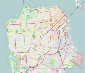 Bayview-Hunters Point Location within San Francisco | |
| Coordinates: 37°43′37″N 122°23′19″W / 37.72687°N 122.38873°WCoordinates: 37°43′37″N 122°23′19″W / 37.72687°N 122.38873°W | |
| Country |
|
| State |
|
| City-county | San Francisco |
| Government | |
| • Supervisor | Malia Cohen |
| • Assemblymember | David Chiu (D)[1] |
| • State senator | Scott Wiener (D)[1] |
| • U. S. rep. | Nancy Pelosi (D)[2] |
| Area[3] | |
| • Total | 3.95 sq mi (10.2 km2) |
| Population (2010)[4] | |
| • Total | 35,890 |
| Time zone | Pacific (UTC−8) |
| • Summer (DST) | PDT (UTC−7) |
| ZIP code | 94124 |
| Area codes | 415/628 |

Bayview-Hunters Point or The Bayview, is a neighborhood in the southeastern corner of San Francisco, California, United States. The decommissioned Hunters Point Naval Shipyard is located within its boundaries and Candlestick Park, which was demolished in 2015, was on the southern edge.
Redevelopment projects for the neighborhood became the dominant issue of the 1990s and 2000s. Efforts include the Bayview Redevelopment Plan for Area B, which includes approximately 1300 acres of existing residential, commercial and industrial lands. This plan identifies seven economic activity nodes within the area. The former Navy Shipyard waterfront property is also the target of redevelopment to include residential, commercial, and recreational areas.[5]
Geography
The Bayview-Hunters Point district is located in the southeastern part of San Francisco, strung along the main artery of Third Street from India Basin to Candlestick Point. The boundaries are Cesar Chavez Boulevard to the north, U.S. Highway 101 (Bayshore Freeway) to the west, Bayview Hill to the south, and the San Francisco Bay to the east. Neighborhoods within the district include Hunters Point, India Basin, Bayview, Silver Terrace, Bret Harte, Islais Creek Estuary and South Basin. The entire southern half of the neighborhood is the Candlestick Point State Recreation Area as well as the Candlestick Park Stadium.[3]
History
Primarily composed of tidal wetlands with some small hills, the area was inhabited by the Ohlone people prior to the arrival of Spanish missionaries in the 1700s. It was first surveyed in 1775 by Juan Bautista Aguirre,[6] a ship pilot for Captain Juan Manuel de Ayala who named it La Punta Concha (English: Conch Point).[7] Later explorers renamed it Beacon Point.[8] For the next several decades it was used as pasture for cattle run by the Franciscan monks at Mission Dolores.[7]
In 1839, the area was part of the 4,446-acre (17.99 km2) Rancho Rincon de las Salinas y Potrero Viejo Mexican land grant given to José Cornelio Bernal (1796–1842). Following the California Gold Rush, Bernal sold Bayview-Hunters Point property for real estate development in 1849. Little actual development occurred but Bernal's agents were three brothers, John, Phillip and Robert Hunter, who built their homes and dairy farm on the land (then near the present-day corner of Griffith Street and Oakdale Avenue) and who gave rise to the name Hunters Point.[7]
After a San Francisco ordinance in 1868 banned the slaughter and processing of animals within the city proper, a group of butchers established a "butchers reservation" on 81-acre (0.33 km2) of tidal marshland in the Bayview district. Within ten years, 18 slaughterhouses were located in the area along with their associated production facilities for tanning, fertilizer, wool and tallow. The "reservation" (then bounded by present-day Ingalls Street, Third Street, from Islais Creek to Bayshore) and the surrounding houses and businesses became known as Butchertown. The butcher industry declined following the 1906 San Francisco earthquake until 1971 when the final slaughterhouse closed.[9]
Shipbuilding became integral to Bayview-Hunters Point in 1867 with the construction there of the first permanent drydock on the Pacific coast. The Hunters Point Dry Docks were greatly expanded by Union Iron Works and Bethlehem Shipbuilding Corporation and were capable of housing the largest ships that could pass through the locks of the Panama Canal. World War I increased the contracts there for building Naval vessels and, in 1940, the United States Navy purchased a section of property to develop the San Francisco Naval Shipyard.[7] Beginning in the 1920s, a strong presence of Maltese American immigrants, along with Italian Americans, began populating the Bayview, focused on the local Catholic St. Paul of the Shipwreck Church and the Maltese American Social Club. They were a presence until the 1960s when they began moving into the suburbs.
The shipbuilding industry saw a large influx of blue collar workers into the neighborhood, many of them African Americans taking part in the Great Migration. This migration into Bayview increased substantially after World War II due to racial segregation and eviction of African Americans from homes elsewhere in the city.[10] Between 1940 and 1950, the population of Bayview saw a fourfold increase to 51,000 residents.[11]
The Bayview-Hunters Point district was labelled "Southern San Francisco" on some maps, not to be confused with the city of South San Francisco further to the south.
Until 1969, the Hunters Point shipyard was the site of the Naval Radiological Defense Laboratory (NRDL). The NRDL decontaminated ships exposed to atomic weapons testing and also researched the effects of radiation on materials and living organisms.[12] This caused widespread radiological contamination and, in 1989, the base was declared a Superfund site requiring long-term clean-up.[13][14] The Navy closed the shipyard and Naval base in 1994. The Base Realignment and Closure program manages various pollution remediation projects.[12]
From 1929 until 2006 the Bayview-Hunters Point district were home for the coal and oil-fired power plants which provided electricity to San Francisco. Smokestack effluvium and byproducts dumped in the vicinity have been cited for health and environmental problems in the neighborhood. In 1994, the San Francisco Energy Company proposed building another power plant in the neighborhood, but community activists protested and pushed to have the current facility shut down.[15] In 2008, Pacific Gas and Electric Company demolished the Hunters Point Power Plant and began a two-year remediation project to restore the land for residential development.[16]
By the 1960s, the Bayview and Hunters Point neighborhoods were populated predominantly by African-Americans and other racial minorities, and the area was isolated from San Francisco. The hyphenated name "Bayview-Hunters Point" became the official designation for the district.[3] Pollution, substandard housing, declining infrastructure, limited employment and racial discrimination were notable problems. James Baldwin documented the marginalization of the community in a 1963 documentary stating "this is the San Francisco, America pretends does not exist."[8][17] In 1966, racial tensions sparked a race riot at Hunters Point.[18] Closure of the naval shipyard, shipbuilding facilities and de-industrialization of the district in the 1970s and 1980s increased unemployment and local poverty levels.[8]
Building projects to revitalize the district began in earnest in the 1990s and the 2000s. As in the rest of the city, housing prices rose 342% between 1996 and 2008. Many long-time African American residents, whether they could no longer afford to live there or sought to take advantage of their homes' soaring values, left what they perceived as an unsafe neighborhood and made an exodus to the Bay Area's outer suburbs. Once considered a historic African American district, the percentage of black people in the Bayview-Hunters Point population declined from 65 percent in 1990 to a minority in 2000.[19] Despite the decline, the 2010 U.S. Census shows the African American population in the Bayview to be greater in number than that of any other ethnicity.
In the 2000s, the neighborhood became the focus of several redevelopment projects. The MUNI[20] T-Third Street light-rail project was built through the neighborhood, replacing an aging bus line with several new stations, street lamps and landscaping. Private developer Lennar Inc. proposed a $2-billion project to build 10,500 homes, including rentals, and commercial spaces atop the former Hunters Point Naval Shipyard, and a new football stadium for the San Francisco 49'ers, and a shopping complex for Candlestick Point. The stadium would reinvigorate the district, but the 49ers changed their focus to Santa Clara in 2006. A bid for the 2016 Summer Olympics in San Francisco that included plans to build an Olympic Village in Bayview-Hunters Point was also dropped.[21] Lennar Inc. proposed to build the stadium without the football team.[22] Local community activist groups have criticized much of the redevelopment for displacing rather than benefiting existing neighborhood residents.[8]
As of 2014, Lennar works on the mixed-use development, promising "12,500 new homes; 4 million-plus square feet of office, commercial and retail space; and 300 acres of open parks, trails and fields", although no rentals.[23]
Demographics
According to the 2010 U.S. Census, Bayview-Hunters Point (ZIP 94124) had a population of 33,996, an increase of 826 from 2000. The census data showed the single-race racial composition of Bayview-Hunters Point was 33.7% African-American, 30.7% Asian (22.1% Chinese, 3.1% Filipino, 2.9% Vietnamese, 0.4% Cambodian, 0.3% Indian, 0.2% Burmese, 0.2% Korean, 0.2% Japanese, 0.2% Pakistani, 0.1% Laotian), 12.1% White, 3.2% Native Hawaiian or Pacific Islander (2.4% Samoan, 0.1% Tongan, 0.1% Native Hawaiian), 0.7% Native American, 15.1% other, and 5.1% mixed race. Of Bayview's population, 24.9% was of Hispanic or Latino origin, of any race (11.5% Mexican, 4.2% Salvadoran, 2.6% Guatemalan, 1.4% Honduran, 1.4% Nicaraguan, 0.7% Puerto Rican, 0.2% Peruvian, 0.2% Spanish, 0.2% Spaniard, 0.1% Colombian, 0.1% Cuban, 0.1% Panamanian).[24]
According to the 2010 U.S. Census, Bayview-Hunters Point had the highest percentage of African-Americans among San Francisco neighborhoods, home to 21.5% of the city's Black population, and they were the predominant ethnic group in the Bayview. Census figures showed the percentage of African-Americans in Bayview declined from 48% in 2000 to 33.7% in 2010, while the percentage of Asian and White ethnicity increased from 24% and 10%, respectively, to 30.7% and 12.1%. However the eastern part of the neighborhood had a population of 12,308 and is still roughly 53% African-American.
According to the 2005-2009 American Community Survey (ACS), the Bayview district is estimated to have 10,540 housing units and an estimated owner-occupancy rate of 51%. The 2010 U.S. Census indicates the number of households to be 9,717, of which 155 belong to same-sex couples. Median home values were estimated in 2009 to be $586,201,[4] but that has since fallen dramatically to around $367,000 in 2011, the lowest of any of San Francisco's ZIP code areas.[25] Median Household Income was estimated in 2009 at $43,155.[4] Rent prices in the Bayview remain relatively low, by San Francisco standards, with over 50% of rents paid in 2009 at less than $750/mo.[26]
A recent Brookings Institution report identified Hunters Point as one of five Bay Area "extreme poverty" neighborhoods, in which over 40% of the inhabitants live below the Federal poverty level of an income of $22,300 for a family of four.[27] Nearly 12% of the population in the Bayview receives public assistance income, three times the national average, and more than double the state average. While the Bayview has a higher percentage of the population receiving either Social Security or retirement income than the state or national averages, the dollar amounts that these people receive is less than the averages in either the state or the nation.
Marginalization
Since the 1960s, the Bayview-Hunters Point community has been cited as a significant example of marginalization.[8] In 2011, it remained "one of the most economically disadvantaged areas of San Francisco".[28] Root causes include a working class populace historically segregated to the outskirts of the city, high levels of industrial pollution, the closure of industry, and loss of infrastructure.[8] The results have been high rates of unemployment, poverty, disease and crime.[8][29] Attempts to mitigate the effects of marginalization include the city's building of the Third Street light-rail line, establishment of the Southeast Community Facility (SECF) as a response from the SF Public Utilities Commission to a community-led effort to balance environmental injustice associated with public utilities,[30] the Southeast Food Access Workgroup,[31] initially formed by the SF Department of Public Health as part of the SF Mayor's ShapeUp SF health initiative, and implementation of enhanced local hiring policy that recognizes that regulations requiring hiring for public projects prioritize City residents and contractors may not help specific neighborhoods where job seekers and contractors may still be overlooked. Place-based and asset-based community building programs networked through the Quesada Gardens Initiative began in 2002 adding direct grassroots public participation to the social and environmental change landscape with a goal of preserving diversity and encouraging longterm residents to reinvest in their neighborhood.
The Hunter's Point shipyard's toxic waste pollution has been cited for elevated rates of asthma and other respiratory diseases among residents.[28] Clean-up of the site is underway.
Gang and drug activity, as well as a high murder rate, have plagued the Bayview-Hunters Point district.[32] A 2001 feature article in the San Francisco Chronicle cited feuding between small local gangs as the major cause of the area's unsolved homicides.[29] In 2011, The New York Times described Bayview as "one of the city’s most violent" neighborhoods.[33] Police have made the removal of guns from the streets their top priority in recent years, leading to a 20% decline in major crimes between 2010 and 2011, including declines of 35% in homicides, 22% in aggravated assaults, 38% in arson, 30% in burglary, 34% in theft, 23% in auto theft, and 39% in robbery. Lesser crimes have also declined by about 24% over the past year.
Until the late 2000s the neighborhood had no chain supermarkets, as many corporate chains could not afford to lease a retail space.[34] In 2011, a San Francisco official described the area as "a food desert - an area with limited access to affordable, nutritious food like fresh produce at a full-size grocery store."[35] A large swath of the southeast sector of San Francisco sits within a Federally recognized food desert.[36] A Home Depot was approved by the city to be built in the area, but the Home Depot Corporation abandoned its plans following the late 2000s economic crisis.[37] Lowe's took over Home Depot's plans, and in 2010 opened their first store in San Francisco on the Bayshore Blvd. site. In August 2011, UK supermarket chain Tesco, owner of Fresh and Easy stores, opened Bayview-Hunters Point's first new grocery store in 20 years, though this store has closed as part of Fresh and Easy's larger corporate exit from the United States.[35][38]
The neighborhood was the subject of a 2003 documentary, Straight Outta Hunters Point,[39] directed by lifelong Hunters Point resident Kevin Epps, and a 2012 sequel, "Straight Outta Hunters Point 2," movies that expose the daily drama of gang-related wars plaguing a community already fighting for social and economic survival. The Spike Lee film Sucker Free City used Hunters Point as a backdrop for a story on gentrification and street gangs.[40]
Community activism
A number of community groups, such as the India Basin Neighborhood Association,[41] the Quesada Gardens Initiative,[42] Literacy for Environmental Justice,[43] the Bayview Merchants' Association,[44] and the Bayview Footprints Collaboration of Community-Building Groups[45] work with community members, other organizations and citywide agencies to strengthen and improve this diverse part of San Francisco.
Community gardening, art, and social history are popular in the area. The Quesada Gardens Initiative is a well recognized organization that has created a cluster of 35 community and backyard gardens in the heart of the neighborhood, including the original Quesada Garden on the 1700 block of Quesada Ave., the Founders' Garden, Bridgeview Teaching and Learning Garden (which won the 2011 Neighborhood Empowerment Network's[46] "Best Green Community Project Award," Krispy Korners, the Latona Community Garden, and the new Palou Community Garden. Major public art pieces honor unique hyper-local history, grassroots involvement, and the right of communities to define themselves.
Landmarks and attractions
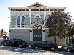
Four buildings in the district are listed in the California Registry of Historic Places. The Bayview Opera House (previously South San Francisco Opera House), located at 4705 Third St., was constructed in 1888 and designated a California landmark on December 8, 1968. It was nominated for the National Registry in 2010,[47] and won the Governor's Award for Historic Preservation in 2011.[48] Quinn House, located at 1562 McKinnon Avenue, was built in 1875 and designated 6 July 1974.[49] The Albion Brewery was built in 1870 and opened as the Albion Ale And Porter Brewing Company. Located at 881 Innes Avenue, it was designated April 5, 1974.[50] Sylvester House at 1556 Revere was built in 1870 and designated on April 5, 1974.[51]
Bayview is home to two large parks: Bayview Park, located on Key Avenue offers sweeping views of the city; and the Candlestick Point State Recreation Area located on the bay south of Bayview Hill at Candlestick Point is a popular attraction for kayakers and windsurfers. Heron's Head Park, located in the northern part of the neighborhood, is home to a recently resurgent population of Ridgway's rails[52] and the EPA Award-Winning[53] Heron's Head Eco Center.
Speakeasy Brewery offers tours and beer and hosts live music at their "Final Friday" events.[54] Restaurants such as Chef Eskender Aseged's Radio Africa & Kitchen,[55] Old Skool Cafe,[56] Limón Rotisserie,[57] and Brown Sugar Kitchen,[58] join an existing group of established restaurants up and down the Third Street corridor, including Sam Jordan's, Frisco Fried,[59] and Las Isletas.
The San Francisco Wholesale Produce Market,[60] located on Jerrold Ave., has been at the center of food distribution in San Francisco since long before moving to its Bayview location in 1964.
The Hunters Point Shipyard is home to the country's largest artist colony, "The Point".[61]
The Quesada Garden,[62] located on Quesada Avenue and 3rd Street in the heart of the neighborhood, is a landmark community open space on a public right-of-way. It is connected to a showcase community food producing garden (Bridgeview Community Teaching and Learning Garden) by two large murals produced with the community by artists Deidre DeFranceaux, Santie Huckaby, Malik Seneferu, and Heidi Hardin. Together, these projects have turned one of the most dangerous and blighted corridors in San Francisco into the safe route through the neighborhood, and have created a destination point for residents and visitors. Karl Paige and Annette Young Smith, retired residents, started planting on an urban median strip in 2002, and were quickly joined by neighbors to complete what is now a 650-foot by 20-foot focal point for flowers, food, art and community building. Thirteen mature Canary Island date palm trees on the block are on the San Francisco Registry of Historic Trees.
Redevelopment
The Anna E. Waden Library, currently undergoing major renovations and improvements, is located at Third Street and Revere, where the Neighborhood History Preservation Project is housed.[63]
Hunters Point Shipyard is a redevelopment project by Lennar Corporation on the 702 acres at Candlestick Point and the San Francisco Naval Shipyard.[64] The plan called for 10,500 residential units, a new stadium to replace Candlestick Park, 3,700,000 square feet (340,000 m2) of commercial and retail space,an 8,000- to 10,000-square-foot (930 m2) arena; artists’ village and 336 acres of waterfront park and recreational area.[65] The developers said the project would contribute up to 12,000 permanent jobs and 13,000 induced jobs.[66]
The approval process required developers to address concerns of area residents and San Francisco government officials. Criticism of the project focused on the large-scale toxic clean-up of the industrial superfund site, environmental impact of waterfront construction, displacement of an impoverished neighborhood populace and a required build-up to solve transportation needs.[65]
In July 2010, Lennar Corporation received initial approval of an Environmental Impact Report from San Francisco supervisors.[66][67] In September 2011, the court denied the transfer of property to Lennar Corporation prior to clean-up of contamination.[28]
Notable residents
- 11/5, defunct gangsta rap group from the Oakdale public housing projects in Hunters Point
- Desmond Bishop, professional NFL player
- Kevin Epps, filmmaker best known for the documentary Straight Outta Hunters Point[68][69]
- Stevie Johnson (b. 1986), NFL player, wide receiver for the San Diego Chargers, born and raised in Hunters Point before moving to Fairfield, CA
- Eric Melvin, guitarist for NOFX
- RBL Posse, gangsta rap group from Harbor Road public housing projects in Hunters Point
- Donald Strickland (b. 1980), NFL player, free agent cornerback who played for the San Francisco 49ers, Indianapolis Colts and New York Jets
- Terri J. Vaughn (b. 1969), actress born and raised in Bayview-Hunters Point[70]
- Eric Wright (b. 1985), NFL player, cornerback for the San Francisco 49ers
References
- 1 2 "Statewide Database". UC Regents. Retrieved November 5, 2014.
- ↑ "California's 12th Congressional District - Representatives & District Map". Civic Impulse, LLC.
- 1 2 3 "Bayview-Hunters Point: Area B Survey" (PDF). San Francisco Redevelopment Agency. 11 February 2010: 4.
- 1 2 3 "San Francisco Neighborhoods: Socio-Economic Profiles; American Community Survey 2005-2009". San Francisco Planning Department. May 2011: 8.
- ↑ Upton, John (June 3, 2010). "Hunters Point Naval Shipyard development faces vote". Retrieved June 3, 2010.
- ↑ Scott, Mel (September 1985). The San Francisco Bay Area: A Metropolis in Perspective (2nd ed.). University of California Press. p. 8. ISBN 978-0-520-05512-4.
- 1 2 3 4 O'Brien, Tricia (August 1, 2005). San Francisco's Bayview Hunters Point. Arcadia Publishing. pp. 7–9. ISBN 978-0-7385-3007-9.
- 1 2 3 4 5 6 7 Dillon, Lindsey (2 August 2011). "Redevelopment and the Politics of Place in Bayview-Hunters Point". Institute for the Study of Social Change, UC Berkeley: 9–34.
- ↑ Casey, Conor (2007). "San Francisco's "Butchertown" in the 1920s and 1930s: A Neighborhood Social History (Volume 18, Number 1)". The Argonaut (Spring).
- ↑ Joe, Ellen; Schwartz, Sara L.; Austin, Michael J. (2008). "The Bayview Hunters Point Foundation for Community Improvement: A Pioneering Multi-Ethnic Human Service Organization (1971-2008)" (PDF). University of California, Berkeley: Mack Center on Nonprofit Management in the Human Services: 4.
- ↑ Jeffries, Amy (2006). "A Brief History of Bayview-Hunters Point". Profile:Bayview Hunters Point. UC Berkeley Graduate School of Journalism.
- 1 2 "Former Naval Shipyard Hunters Point". BRAC Program Management Office. Department of the Navy. Retrieved 2011-05-14.
- ↑ "Treasure Island Naval Station-Hunters Point Annex Superfund site progress profile". EPA. Retrieved April 25, 2010.
- ↑ "Treasure Island Naval Station-Hunters Point Annex Superfund site partial deletion narrative". EPA. Retrieved April 25, 2010.
- ↑ Rechtschaffen, Clifford (1995–1996). "Fighting Back against a Power Plant: Some Lessons from the Legal and Organizing Efforts of the Bayview-Hunters Point Community". Hastings W.-Nw. J. Envt'l L. & Pol'y: 407.
- ↑ "Hunters Point power plant demolished". ABC News. 19 September 2008.
- ↑ KQED, 1963, Take This Hammer, San Francisco Bay Are Area Television Archives
- ↑ Rucker, Walter C.; Upton, James N. (November 30, 2006). Encyclopedia of American Race Riots. Greenwood. pp. 583–4. ISBN 978-0-313-33301-9.
- ↑ McCormick, Erin (January 14, 2008). "Bayview revitalization comes with huge price to black residents". San Francisco Chronicle. Retrieved 2011-09-28.
- ↑ "San Francisco Municipal Transportation Agency (SFMTA, Muni, Sustainable Streets)". Sfmta.com. 2012-12-26. Retrieved 2012-12-31.
- ↑ Crumpacker, John (November 14, 2006). "'Shocked' S.F. group drops bid for 2016 Olympics". San Francisco Chronicle.
- ↑ Selna, Robert (November 10, 2006). "49ERS ON THE MOVE / Stadium plan stuns and disappoints / HUNTERS POINT: Area residents see York's decision as one more broken promise". San Francisco Chronicle.
- ↑ Cadei, Emily (1 July 2014). "Kofi Bonner: Community Building ? for Profit". Ozymandias. Retrieved 19 July 2014.
- ↑ "American FactFinder". Factfinder2.census.gov. Archived from the original on 2013-09-11. Retrieved 2012-12-31.
- ↑ "94124 Home Prices and Home Values - Zillow Local Info". Zillow.com. 2012-12-16. Retrieved 2012-12-31.
- ↑ "94124 Zip Code (San Francisco, California) Profile - homes, apartments, schools, population, income, averages, housing, demographics, location, statistics, sex offenders, residents and real estate info". City-data.com. Retrieved 2012-12-31.
- ↑ "Archived copy" (PDF). Archived from the original (PDF) on 2012-01-25. Retrieved 2011-11-08.
- 1 2 3 Browne, Jaron (16 September 2011). "Court blocks Hunters Point Shipyard redevelopment until Navy completes toxic cleanup". San Francisco Bay View National Black Newspaper.
- 1 2 Sward, Susan (December 16, 2001). "THE KILLING STREETS / A Cycle of Vengeance / BLOOD FEUD / In Bayview-Hunters Point, a series of unsolved homicides has devastated one of S.F.'s most close-knit communities". The San Francisco Chronicle.
- ↑ "SFGov : Southeast Community Facility Commission". Sfgov3.org. 2012-12-04. Retrieved 2012-12-31.
- ↑ "SFGov : Southeast Food Access (SEFA) Workgroup". Sfgov3.org. Retrieved 2012-12-31.
- ↑ Vega, Cecilia M. (January 15, 2008). "Guns, crack cocaine fuel homicides in S.F. - 98 killings in 2007". The San Francisco Chronicle. Retrieved 2011-08-02.
- ↑ Bundy, Trey (August 7, 2011). "A Neighborhood Is Shaken by a Violent Death". New York Times. p. A21A.
- ↑ Tesco signs deal for Fresh & Easy store in Bayview by J.K. Dineen, San Francisco Business Times, December 11, 2007, access date June 28, 2008
- 1 2 Coté, John (August 25, 2011). "After years, Bayview will finally get full-service grocery store". The San Francisco Chronicle.
- ↑ "USDA ERS - Go to the Locator". Ers.usda.gov. 2012-08-23. Retrieved 2012-12-31.
- ↑ Selna, Robert (April 1, 2008). "Best and worst of City Hall". The San Francisco Chronicle.
- ↑ Vickers, Emma (April 12, 2013). "Tesco expected to scrap struggling US grocery chain Fresh & Easy". The Guardian.
- ↑ http://www.imdb.com/title/tt0369993/
- ↑ Wagner, Venise (June 29, 2001). "Straight outta Hunters Point / Kevin Epps's bleak documentary shows the disintegration of a place he has called home for 30 years". The San Francisco Chronicle.
- ↑ India Basin Neighborhood Association Archived November 23, 2005, at the Wayback Machine.
- ↑ "quesadagardens.org". quesadagardens.org. Retrieved 2012-12-31.
- ↑ "About Us". Lejyouth.org. Archived from the original on 2012-11-08. Retrieved 2012-12-31.
- ↑ "bayviewmerchants.org". bayviewmerchants.org. 2006-05-28. Retrieved 2012-12-31.
- ↑ "bayviewfootprints.org". bayviewfootprints.org. Retrieved 2012-12-31.
- ↑ "NEN Awards". Empowersf.org. Retrieved 2012-12-31.
- ↑ http://ohp.parks.ca.gov/pages/1067/files/south%20san%20francisco%20opera%20house%20draft%20nr%20nomination.pdf
- ↑ http://bvoh.org/news/pressReleases/pdf/BVOH_Governor%27s_Award_10-28-2011.pdf
- ↑ "San Francisco Landmark #63: Quinn House". Noehill.com. Retrieved 2012-12-31.
- ↑ Alvis Hendley (2005-06-09). "San Francisco Landmark 60: Hunters Point Springs-Albion Brewery". Noehill.com. Retrieved 2012-12-31.
- ↑ "San Francisco Landmark #61: Sylvester House". Noehill.com. Retrieved 2012-12-31.
- ↑ Fimrite, Peter (August 24, 2011). "Clapper rails discovered nesting in SF". The San Francisco Chronicle.
- ↑ "SF EcoCenter Wins EPA Award". The Bay Citizen. Retrieved 2012-12-31.
- ↑ "Speakeasy Ales and Lagers". Goodbeer.com. Retrieved 2012-12-31.
- ↑ "Radio Africa & Kitchen". Retrieved 2012-12-31.
- ↑ "Old Skool Cafe". Retrieved 2012-12-31.
- ↑ "Limón Rotisserie". Retrieved 2016-05-24.
- ↑ "Brown Sugar Kitchen". Retrieved 2012-12-31.
- ↑ "Frisco Fried: Down Home San Francisco Style Soul Food". Retrieved 2012-12-31.
- ↑ "Welcome to San Francisco Wholesale Produce Market". Sfproduce.org. Retrieved 2012-12-31.
- ↑ "thePoint | Affordable Artist Studios at San Francisco's Hunters Point Shipyard & Islais Creek". Thepointart.com. 2011-06-17. Retrieved 2012-12-31.
- ↑ "Quesada Gardens". Quesada Gardens. Retrieved 2012-12-31.
- ↑ "Bayview :: San Francisco Public Library". Sfpl.org. 2011-04-02. Retrieved 2012-12-31.
- ↑ "The Grand Plan And Aesthetics For Candlestick/Hunters Point". SocketSite. November 12, 2009. Retrieved November 12, 2009.
- 1 2 Paddock, Richard (April 30, 2010). "Vision for Transforming Hunters Point Comes Before Supervisors". New York Times. Retrieved December 6, 2010.
- 1 2 Carlsen, Robert (July 16, 2010). "SF Supes Approve EIR for Lennar's Hunters Point Plan". California Construction. Archived from the original on 22 July 2010. Retrieved July 16, 2010.
- ↑ Wildermuth, John (July 15, 2010). "Hunters Point shipyard plan wins key approval". The San Francisco Chronicle. Retrieved July 15, 2010.
- ↑ Suzdaltsev, Jules. "Hunters Point Is San Francisco's Radio Active Basement". Vice. Retrieved 12 February 2015.
- ↑ "Straight Outta Hunters Point". Rotten Tomatoes. Retrieved 2015-11-04.
- ↑ Burrell, Y'Anad. "Terri J. Vaughn's, Take Wings Foundation Gala, A Huge Success; UPN A Proud Supporter". www.prweb.com. Retrieved 4 October 2014.
External links
| Wikimedia Commons has media related to Bayview, San Francisco. |
| Wikivoyage has a travel guide for San_Francisco/Bayview-Hunters_Point. |
- Profile: Bayview-Hunters Point 2006 11-part series UC Berkeley School of Journalism
- Community-building through informal resident-led groups known as Quesada Gardens Initiative
- Community's user-generated calendar of events created by Footprints community network
- Bayview Merchants' Association
- Bay View Newspaper
- Bayview MAGIC - Community of color collaborative
- Historic Hunters Point in pictures
- India Basin Neighborhood Association
- Map of India Basin
- Islais Creek History Neighborhood Parks Council
- Hunters Point infant mortality rate is comparable to Bulgaria
- Hunters Point Shipyard redevelopment
- 1966 Hunters Point riot
- Review of a documentary film about Hunters Point
- Alternative economic development for Bayview-Hunters Point
- Community Window on the Shipyard, an archive of Shipyard-related documents
- Literacy for Environmental Justice, a local organization working on Environmental Justice issues in Hunters Point
- Artists at Hunters Point Shipyard
- Department of the Navy BRAC Program Management Office
 |
Potrero Hill District, Mission Bay |
| |||||
| Bernal Heights District | |
||||||
| Mission District | |
San Francisco Bay | |||||
| |
|||||||
| Visitation Valley District | Brisbane |
| Downtown | .svg.png) | |
|---|---|---|
| North of Downtown | ||
| Outside Lands | ||
| Western Addition | ||
| Southern | ||
| ||
