Hulu Perak District
| Hulu Perak District | ||
|---|---|---|
| District of Malaysia | ||
| ||
 | ||
| Country |
| |
| State |
| |
| Seat | Gerik | |
| Government | ||
| • District officer | n/a | |
| Area | ||
| • Total | 6,563 km2 (2,534 sq mi) | |
| Population (2010) | ||
| • Total | 44,056 | |
| • Density | 6.7/km2 (17/sq mi) | |

The Hulu Perak District is one of twelve administrative districts located in the north-east corner of Perak in Malaysia. To the east of the district is the state of Kelantan, to the west is Kedah, to the south is the district of Kuala Kangsar while to the south-west is the district of Larut, Matang and Selama. Hulu Perak also shares a border with Betong District of Thailand. The main district capital is Gerik.
Geography
The geography of Hulu Perak district features the Titiwangsa Mountains, with 1,533 m high Ulu Titi Basah peak located on the Thai/Malaysian border, and Temenggor Lake.[1]
History
In 1511, after the fall of the Malacca Sultanate to the Portuguese, Sultan Mahmud Shah retreated and established his government in Bentan. In 1526 the Portuguese attacked his domain again and forced him to retreat to Kampar and to establish his rule there.
At that time, Tun Saban had moved to Upper Patani and stayed at Beredung Budi. He then moved to Belum Forest in Hulu Perak, founded a village at a place called Relap Hati, and became the chief of the peoples in Belum Forest.
For sometime until the 19th century, a good part of this district was under the sovereignty of Siam, as part of the old Malay kingdom of Reman. The area then under Thai control included what is today Gerik, Pengkalan Hulu (Kroh), Kerunai, the Belum forest and the Temenggor Lakes. The capital of Reman was near Pengkalan Hulu. [2]
In 1882, the border between the then-British protected state of Perak and the Siamese vassal state of Reman was delimited at Bukit Nasha, some 5 km south of Gerik town.
An adjustment in 1899 transferred Gerik town and the surrounding commune to the Federated Malay States, which Perak was then part of.
The present-day border, part of the longer Malaysia-Thailand border, was finalised in 1909, when the districts of Pengkalan Hulu, Kerunai, Belukar Semang, Belum and the present-day Temenggor Lakes were transferred to the FMS. The British also gained control of Perlis, Kedah, Kelantan and Terengganu.
Administrative divisions
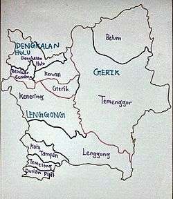
Hulu Perak District is divided into 10 mukims, which are:
- Belukar Semang
- Belum
- Durian Pipit
- Gerik
- Kenering
- Kerunai
- Lenggong
- Pengkalan Hulu
- Temelong
- Temenggor
Government
Three district councils administer the district:
- Gerik District Council, based at the town of Gerik - a district capital of Hulu Perak
- Lenggong District Council, based at the town of Lenggong
- Pengkalan Hulu District Council, based at the town of Pengkalan Hulu (previously known as Keroh)
See also
| Wikimedia Commons has media related to Hulu Perak. |
References
- ↑ "Gunong Ulu Titi Basah: Thailand". Geographic.org. 1994-04-06. Retrieved 2013-04-30.
- ↑ "Perang saudara di Hulu Perak". Utusan Online. Utusan Malaysia. Retrieved 16 October 2016.
5°31′N 101°22′E / 5.51°N 101.36°ECoordinates: 5°31′N 101°22′E / 5.51°N 101.36°E