Huckleberry Trail
| Huckleberry Trail | |
|---|---|
|
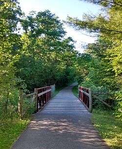
Huckleberry Trail, bridge over Slate Branch near Merrimac, Virginia | |
| Length | 7 mi (11 km) |
| Location | Montgomery County, Virginia |
| Designation | Community Millennium Trail |
| Use | Hiking, bicycling, etc. |
| Hiking details | |
| Trail difficulty | Easy |
| Season | Year-round |
| Sights |
Appalachian Mountains Virginia Tech |
The Huckleberry Trail is a 7-mile (11 km) rail trail in Montgomery County, Virginia, connecting the towns of Blacksburg and Christiansburg. The trail is 12 feet (3.7 m) wide with an asphalt surface.[1]
The trail takes its name from the former route of the Virginia Anthracite Coal and Railway Company, nicknamed the "Huckleberry", upon which the trail was constructed.[2] The "Huckleberry" moniker was introduced by the railroad's passengers, who would pick huckleberries alongside the tracks during the railroad's frequent service interruptions and breakdowns.[1]
History
With passenger service ending in 1958 and the subsequent abandonment of the line in 1967, the former railroad right-of-way remained unused until the idea of its conversion to a pedestrian trail arose in the 1980s.[1] In February 1990, Montgomery County approved what would be named the Huckleberry Trail as the county's first bikeway.[2] After a successful grassroots fundraising campaign for the trail's construction, in October 1993 the Commonwealth Transportation Board awarded the Huckleberry project $453,424 towards its construction.[3]
Originally scheduled to commence construction in early 1994, delays resulting from ADA accessibility and prehistoric archaeological sites along the trail's path resulted in some adjustments to its route.[4] Additionally, higher costs from the construction of a tunnel and enhanced emergency vehicle access caused the project to run out of its initial funds and be placed on hold.[4] After these delays and the securing of additional funding, construction began on the initial 3.2-mile (5.1 km) segment between the Montgomery-Floyd Regional Library in Blacksburg and the intersection of Hightop and Merrimac Roads in Merrimac on April 5, 1996.[5] Although the trail was used by the public before this date, it officially opened in a ribbon-cutting ceremony on December 7, 1996.[6]
Immediately following the completion of the initial phase, bidding for the construction of the second phase began with an initial completion date estimated for late 1997.[6] However, estimated costs for the completion of the second segment came in well over budget, resulting in the project being pushed back until additional funding could be secured.[7] With Blacksburg, Christiansburg and Montgomery County all contributing additional funding, construction of the second phase was completed in late 1998, with the ribbon-cutting ceremony occurring on December 1, 1998.[8] The completed trail cost $1.4 million, with federal transportation grants covering about $690,000 of the total cost.[8]
On June 1, 2000, the Huckleberry Trail's success was recognized by the federal government when it was named one of the nation's 2,000 Community Millennium Trails.[9]
On June 29, 2015, the Huckleberry Trail's Renva Knowles Bridge opened, crossing over Peppers Ferry Road near the New River Valley Mall, and the path was extended south to Cambria Street in Christiansburg, with a spur connecting the Huckleberry Trail to the Christiansburg Recreation Center via Cambria Street and North Franklin Street.[10]
Route description
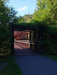
The Huckleberry Trail's trailhead in downtown Blacksburg is on Draper Road next to the Montgomery-Floyd Regional Library. From there, it heads south out of town, crossing Southgate Drive on a bridge, until it reaches the edge of the Virginia Tech Montgomery Executive Airport. From there, it heads west, crossing Tech Center Drive and passing under Route 460 in a tunnel. South of Route 460, a spur heads northeast to the Hethwood neighborhood and Prices Fork Road. This spur is part of an incomplete future extension to the Jefferson National Forest. After crossing Route 460, the main trail follows the highway southeast to Slate Branch, then follows Slate Branch south to the unincorporated community of Merrimac. The trail crosses Merrimac Road and passes through the Coal Mining Heritage Park. Continuing south, it crosses over the Norfolk Southern Railway on a bridge, enters a road cut, and passes behind the New River Valley Mall. It crosses Peppers Ferry Road on the Renva Knowles Bridge and terminates at Cambria Street in Christiansburg. A trail spur continues along Cambria Street and North Franklin Street to the Christiansburg Recreation Center.
Coal Mining Heritage Park
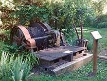
Near the village of Merrimac, the Huckleberry Trail passes through the 29.2-acre (11.8 ha) Coal Mining Heritage Park, which features equipment and part of the foundations of an abandoned coal mine.[11] The park is located on the site of the former Merrimac Mine, which closed in the 1930s. In addition to the coal mine, the site formerly hosted a coal tipple, a hotel, a general store, and residential housing for the miners. The Coal Mining Heritage Park was planned by a collaboration between the Anthropology Program at Radford University, the Montgomery County Planning Office, the Coal Mining Heritage Association of Montgomery County, and the Virginia Department of Historic Resources. It officially opened on September 9, 2000. Located within the park is the Coal Mining Loop Trail, a 1.5-mile (2.4 km) path which opened on November 17, 2010.[12][13]
Future expansion
As of 2016, work is underway to extend the trail to Food Lion Plaza south of the Christiansburg Recreation Center, and there are future plans to extend the trail southward to Independence Boulevard near Christiansburg High School.[14]
A trail extension has been proposed that would connect the Huckleberry Trail at Route 460 to Blacksburg's Heritage Community Park and the Jefferson National Forest's Gateway Trail, and as of 2016 it is partially complete.[14][15][16]
In 2016, work is underway to realign the section of the Huckleberry Trail between Tech Center Drive and Route 460 in connection with the Southgate Connector project. The new alignment will run alongside Southgate Drive, passing close to the Virginia Tech athletics complex and the Virginia–Maryland College of Veterinary Medicine and providing a more direct access to the trail from the Virginia Tech campus.[17]
A future connection to the New River Trail has also been suggested.[16]
References
- 1 2 3 Freis, Robert (August 22, 1993). "Trail picking up steam". The Roanoke Times. p. NRV1.
- 1 2 Sunderland, Kim (February 6, 1990). "Huckleberry Trail proposed as first county bike path". The Roanoke Times. p. NRV2.
- ↑ Lindquist, Rick (October 22, 1993). "Huckleberry Trail takes next steps". The Roanoke Times. p. Virginia, A1.
- 1 2 Freis, Robert (November 17, 1994). "Trail project runs out of funds". The Roanoke Times. p. NRV1.
- ↑ Freis, Robert (April 6, 1996). "Patience will pay off for users of Huckleberry". The Roanoke Times. p. NRV1.
- 1 2 Freis, Robert (December 7, 1996). "Huckleberry trail milestone marked today". The Roanoke Times. p. NRV1.
- ↑ Angleberger, Tom (August 28, 1998). "Trail's end now late fall". The Roanoke Times. p. NRV8.
- 1 2 Freis, Robert (December 2, 1998). "Trail's end is just the start". The Roanoke Times. p. NRV1.
- ↑ Calnam, Christopher; Gangloff, Mike (June 1, 2000). "Three trails to join national list". The Roanoke Times. p. NRV1.
- ↑ Gangloff, Mike (July 1, 2015). "Long-awaited Huckleberry Trail bridge opens in Christiansburg". The Roanoke Times. Retrieved June 29, 2016.
- ↑ "Pocket Parks". Friends of the Huckleberry. Retrieved October 21, 2016.
- ↑ "Coal Mining Heritage Park and Loop Trail". Parks & Recreation, Montgomery County, Virginia. Retrieved October 21, 2016.
- ↑ Mary B. LaLone. "Merrimac Coal Mining Heritage Park Project, 1999-2000". Radford University. Retrieved October 21, 2016.
- 1 2 Gangloff, Mike (May 22, 2015). "Christiansburg begins next stretch of Huckleberry Trail". The Roanoke Times. Retrieved June 29, 2016.
- ↑ Jackson, Todd (May 5, 2013). "High Fives for the Huckleberry". The Roanoke Times. Retrieved May 9, 2013.
- 1 2 "Expansion Plans". Friends of the Huckleberry Trail. Retrieved June 29, 2016.
- ↑ "Southgate Connector - Blacksburg". Virginia Department of Transportation. March 14, 2016. Retrieved June 29, 2016.
External links
- Huckleberry Trail and Coal Mining Heritage Park, Montgomery County Parks & Recreation
- Friends of the Huckleberry Trail
- Merrimac Coal Mining Heritage Park Project, 1999-2000