Huautla de Jiménez
| Huautla de Jiménez | |
|---|---|
| Municipality | |
|
Huautla de Jiménez | |
| Coordinates: 18°7′53″N 96°50′27″W / 18.13139°N 96.84083°WCoordinates: 18°7′53″N 96°50′27″W / 18.13139°N 96.84083°W | |
| Country | Mexico |
| State | Oaxaca |
| Municipal seat | Huautla de Jiménez |
| Largest city | Huautla de Jiménez |
| Area | |
| • Total | 71.45 km2 (27.59 sq mi) |
| Population (2005) | |
| • Total | 31,829 |
| • Density | 450/km2 (1,200/sq mi) |
| Data source: INEGI | |
| Time zone | CST (UTC-6) |
| • Summer (DST) | CDT (UTC-5) |
| Website | (Spanish) |
Huautla de Jimenez is a town and municipality in the Mexican state of Oaxaca. It is part of the Teotitlán District in the north of the Cañada Region.
The name Huautla comes from the Náhuatl. The town is called "Tejao" (also Eagle's Nest) in the Mazatec language. "De Jiménez" was added to honor General Mariano Jiménez, who was the first governor of the state of Oaxaca in 1884 and the first official to arrive on Mazateca lands. He founded the town Huautla de Jiménez, which is now the municipality's seat.
The origin of the town is unknown, but tribute documents show that it was the largest town in the Mazatec region during the late Postclassic period, when the town paid tribute to the Aztec empire.
The town
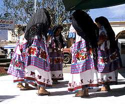
The touristic attractions include the waterfall of the watering-can, the hill of Adoration, and the caves of San Antonio and San Agustín. People also visit the town to buy brightly colored hand-woven fabrics made by the native Mazatec women, and to consume the endemic entheogenic fungi, especially the Psilocybe mushrooms.[1]
The municipality
The municipality possesses a territorial extension of 71.45 km2. It is located to the northwest of the capital of the state of Oaxaca and it bordered to the north by Santa María Chilchotla and San José Tenango. Tehuacan is the nearest city to this community and it is about 4 hours away.[1]
According to the INEGI census of 2005, the total population of the municipality is of 31,829 inhabitants.[2]
Its principal economic activities are agriculture, ranching and retail shops. The agriculture base consists of coffee, corn, sugar cane and fruit-bearing trees. Ranching consists of goats, cows, pigs, horses and mules. Retail stores include food shops, fruit and vegetable stands, butchers, clothes, footwear, newspapers and magazines, etc. It is noted as the birthplace of María Sabina, a Mazatec curandera famous for her use of Psilocybe mushrooms. After publication of an article titled "Seeking the Magic Mushroom," by Robert Gordon Wasson in Life magazine's May 13, 1957 issue,[3] a number of famous people—including John Lennon and Bob Dylan—are alleged to have visited Huautla de Jimenez, seeking the spiritual guidance of Maria Sabina and other shamanic curers.[4]
The municipality has a series of caverns which are the deepest in the Western Hemisphere, possibly in the world, including Sistema Huautla, ’’Gruta Nindo Da-Ge’’, ’’Sistema Cheve’’ and the ’’Sótano de San Agustín’’, which are well known in the caving world. It also has natural springs with crystal-blue waters.[5]
The following communities fall under the governing jurisdiction of the town/municipality:
5 de Mayo, Agua Arco Iris, Agua Álamo, Agua Cabeza de León, Agua Canoa, Agua Caracol, Agua Catitla, Agua de Álamo 1, Agua de Álamo 2, Agua de Carrizo, Agua de Cedro, Agua de Cerro, Agua de Cuerno, Agua de Cueva 1, Agua de Cueva 2, Agua de Estrella, Agua de Flor, Agua de Guayaba, Agua de Hueso (1 ra. Sección), Agua de Hueso (2a. Sección), Agua de la Rosa, Agua de las Flores, Agua de Llano, Agua de Lluvia, Agua de Pluma, Agua de Pozol (San Ramón), Agua de Tierra 1, Agua de Tierra 2, Agua de Tigre, Agua de Tijera, Agua de Tinta, Agua de Yerba Santa, Agua del Monte, Agua Elite (Zoo Yaá n´de), Agua Escalera, Agua Flor Fría 1, Agua Flor Fría 2, Agua Hundida, Agua Iglesia, Agua Neblina, Agua Palmera, Agua Pegado, Agua Sangre, Agua Temazcal, Barranca Seca, Barrio Loma Fortín, Camino Viejo Ayautla, Campo de Aviación Lázaro Cárdenas, Cerro Golondrina, Cerro Iglesia, Cerro Mejía, Cerro Ocote, Cerro Panteón, Cerro Zongolica, Colonia del Valle, Colonia San Rafael, Cruz de Fierro, El Carrizal, Encinal Huautla, Faustino Carrera (Rancho Encinal), Hilatepec Huautla de Jiménez, La Finca, La Providencia, Llano de Águila, Llano de Cedro, Llano de Cedro, Llano de Lodo, Llano Verde, Llano Viejo, Loma Alta, Loma Chapultepec, Loma Chilar, Loma de la Plaza, Loma de Panteón, Loma de Pasto, Loma Frutilla, Loma Maguey, Loma Nazareno, Loma Nopal, Los Pinos, Netzahualcóyotl, Nuevo Progreso 1, Nuevo Progreso 2, Palo de Marca, Patio Iglesia, Peña Campana, Peña del Sol, Peña Verde, Piedra Alta, Piedra Colorada, Plan Carlota, Plan de Arena, Plan de Basura, Plan de Escoba, Plan de Joya, Plan de Lecho, Plan de Ocote, Poza Rica San Andrés, Rancho de Cura, Rancho la Mina, Río Santiago, San Agustín Zaragoza, San Andrés Hidalgo, San Felipe, San Pedro del Río, Santa Catarina Buenavista, Santa Clara, Santa Cruz de Juárez, Sitio Largo, Villa Alta, Xochitonalco, and Zongolica
References
- 1 2 "Huautla de Jiménez" (PDF). Retrieved 2008-11-07.
- ↑ "INEGI". Retrieved 2008-11-07.
- ↑ Wasson RG. (13 May 1957). "Seeking the magic mushroom". Life. Time Inc.: 101–20. ISSN 0024-3019.
- ↑ Michiel Baud; Johanna Louisa Ypeij (2009). Cultural Tourism in Latin America: The Politics of Space and Imagery. BRILL. p. 109. ISBN 978-90-04-17640-9.
- ↑ Quintanar Hinojosa, Beatriz (August 2007). "El trópico oaxaqueño". Guía México Desconocido: Oaxaca. 137: 86–87.