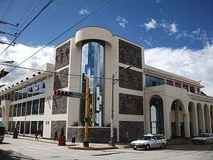
Huaraz
| Huaraz San Sebastian de Huaraz | ||||||||
|---|---|---|---|---|---|---|---|---|
| City | ||||||||
Huaraz | ||||||||
| Motto: The noble and generous City, Switzerland of Peru, Capital of International Friendship, Natural Paradise of the World | ||||||||
 Huaraz Location in Peru | ||||||||
| Coordinates: 9°32′S 77°32′W / 9.533°S 77.533°W | ||||||||
| Country |
| |||||||
| Region | Ancash | |||||||
| Province | Huaraz | |||||||
| Founded | 20 January 1574 | |||||||
| Government | ||||||||
| • Type | Democracy | |||||||
| • Mayor | Vladimir Meza Villareal. | |||||||
| Area | ||||||||
| • Total | 370.03 km2 (142.87 sq mi) | |||||||
| Elevation | 3,052 m (10,013 ft) | |||||||
| Population | ||||||||
| • Estimate (2015)[1] | 127,041 | |||||||
| Time zone | PET (UTC-5) | |||||||
| • Summer (DST) | PET (UTC-5) | |||||||
| Area code(s) | 43 | |||||||
| Website | www.munihuaraz.gob.pe | |||||||


Huaraz (Spanish pronunciation: [waˈɾaθ] or [waˈɾas]) founded as San Sebastian de Huaraz, is a city in Peru. It is the capital of the Ancash Region (State of Ancash) and the seat of government of Huaraz Province. The urban agglomeration's population is distributed over the districts of Huaraz and Independencia. The city is located in the central part of the Callejon de Huaylas Valley and on the right side of the river Santa, in addition the city has an elevation of approximately 3050 metres. The agglomeration has an extension of 8 km2 and a population of 120,000 inhabitants, making it the second largest city in the central Peruvian Andes after the city of Huancayo, and the 22nd largest city in Peru. Huaraz is the headquarters of the province's Roman Catholic Bishop and the site of his official cathedral.
Huaraz is the main financial and commerce center of the Callejón de Huaylas and the main tourist center of Ancash region, moreover, is one of the important cities in the Peruvian Andes. Huaraz is the main place of winter sports and adventure. Many visitors from around the world arrived to the city for practicing sports as climbing, hiking, mountain biking, snowboarding and also to visit the glaciers and mountains of the Cordillera Blanca, mainly the Huascarán snow peak, that is considered the highest mountain in tropics, all of them located in Huascarán National Park that is a nature world heritage site by UNESCO.
The origins of the city came before the Inca Empire with the development of some human settlements surrounding the valley of the Santa River and Qillqay. Its Spanish occupation occurred in 1574 as a Hispanic-indigenous reduction. During the Independence of Peru, the whole city supported the Liberty Army with food and guns, gaining the city the motto of "Noble and Generous City" named in that way by Simón Bolívar. In 1970, 95% of the city was destroyed by an earthquake that damaged a great part of Ancash Region. 25,000 people died. The city was supported with great international help by many countries. For this reason the city was named as a capital of International Friendship.
The main economic activities in the city are agriculture and tourism, because Huaraz has tourist infrastructure supporting the Ancash Highlands, the city is the main point of arrival for practicers of adventure sports and mountaineering. Along with the snow peaks of the Cordillera Blanca, one can visit archaeological sites as Chavín de Huantar and the eastern highlands of Ancash, known as Conchucos.
Etymology
The name of the city comes from the Quechua word "Waraq", that means "sunrise". Because the prehispanic people who lived in the zone, had as a god the "Waraq coyllur" that means "Star of sunrise" or Venus planet, because it is the star that can be seen better from the city at sunrise.
Geography
Location

Huaraz is in north-central Peru, about 420 km north of Lima, and at an altitude of 3,052 metres (10,013 ft). It is the largest population center in the agriculturally important Callejón de Huaylas valley. The Callejón (in Spanish roughly meaning large valley or corridor) is a north-south valley bounded on the east by the Cordillera Blanca (permanent white snowcaps and glaciers) and on the west by the Cordillera Negra (no permanent snowcapped peaks or glaciers, hence black). The Cordillera Blanca includes Huascarán, the highest mountain in Peru at 6,768 metres (22,205 ft) and the third highest in the Western Hemisphere. Huascarán and the adjacent peak Huandoy in fair weather are clearly visible from Huaraz.
The Santa River flows north through Huaraz. It is not commercially navigable but has always furnished the city with good water. The river is a rocky-bottom narrow stream of glacier-fed cold water that flows generally west of center in the Callejón, running north to the valley's north end. There it rushes downward through the narrow Cañón del Pato (duck canyon), turns westward at the town of Huallanca, and continues to the coast where it enters the Pacific Ocean south of the city of Chimbote. The Santa River is the traditional west boundary of Huaraz, although part of the city's population has lived on the west bank there for as long as two centuries.
The nominal north boundary of Huaraz is along a westward flowing creek that empties into the Santa River. The creek, whose watershed is the westward facing nearby foothills and slopes of the Cordillera Blanca, has twice since 1940 been the channel of two devastating earthquake-precipitated floods (see below).
The most recent devastating flood and avalanche along this creek bed was a result of the 1970 earthquake. The avalanche of 1941 had filled the creek valley with debris, covering the new suburb on the city's north edge. The 1970 avalanche and floodwaters down this creek valley destroyed the city's north-side subdivision, which had been partially rebuilt by the late 1960s. The 1970 avalanche debris also created a temporary natural dam across the Santa River, which barrier caused flooding throughout much of the city. The quake had wrecked almost all the city's major buildings. Over the next few days the city was devastated by flooding from both the creek and the river and by water-borne earthquake debris.
Orography
The urban area of Huaraz is located at the Santa River basin. The environment characteristic of the city belongs to an Andean valley. Huaraz is located in the Callejón de Huaylas valley, surrounded by the Cordillera Blanca and Cordillera Negra as its system mountains. The main river is the Santa which crosses the city from south to north, and also the Qillqay river that crosses the urban area from east to west, flowing to the Santa river.
The territory surrounding Huaraz is heterogeneous, mountainous and rough; because of that its slopes have gradients varying between 2% and 25% in the central zone and 15% and 45% in the outskirts.
Layout

Huaraz in its beginning had an architecture composed of circular houses, after that, they were demolished in order to build square houses and narrow streets on a grid plan. The main square used to be wide and was signed at downtown, it was surrounded by the Big Cathedral, the city hall, the jail, the governor in colonial times established his residence in Huaraz, for that reason the city was elevated to the category of region capital.[2]
Of the quiet, silent, old city with big mansions made of mud and gabled-roofs with narrow streets, only José Olaya street remains. It was declared a national heritage site, because the 1970s earthquake destroyed 95% of the city and all the traditional and colonial architecture disappeared, except Olaya Street, robbing the city of its traditional identity.[2]
The grid plan of Huaraz has changed and disappeared the original composition of four neighbourhoods, as La Soledad (downtown), Belén, Huarupampa and San Francisco.
For its rebuilding after the earthquake, the government had to demolish the damaged houses. After that, the city was planned with a modern physiognomy like wide streets and avenues with central gardens. Colonial architecture doesn't exist, it was modernized in its own Andean style of gabled roofs. The city has a modern and planned design, made for Gunther-Seminario Company. Despite that the city grows in a disorganized way. In the other hand, the city had a great commercial movement, and good-quality touristic services, so the fast process of urbanization, had the consequence of irregular neighbourhoods.[2]
The city grew in a longitudinal way from north to south, Only in central downtown there are buildings with more than 3 or 4 floors. Many of the buildings were modified, in order to rent apartments and lofts.
Neighborhoods
The metropolitan area is composed of two districts, Huaraz and Independencia. These are also divided into neighborhoods and settlements, and they also are divided in two or more parts. the majority of neighborhoods are located in Huaraz District, especially the traditional areas like La Soledad, Belén, Huarupampa and San Francisco, that are surrounding the downtown, and its residents are in 60% the traditional citizens of Huaraz. This neighbourhoods, are in great part from middle class. On the other hand, surrounding these areas, there are other settlements that have developed without planning. In the District of Independencia there are other middle- and upper-class neighborhoods. Centenario is the most extensive area in the city. At this area many rural migrants has established developing informal neighbourhoods. The tendency of city's growing is on the north-east part of the city. In north direction has developed areas of recent creation, especially for people searching an ecological area for establish.
Climate
Huaraz has a warm moderated weather of tropical mountain. It is sunny and dry during the morning and cold past the evening, with temperatures between 11-17 °C and maximum temperatures that could overpass 21 °C. During the rainy season, from December to March, rainfall can be between 500 mm and 1000 mm. The dry season, spanning from April to November, is also known as "Andean summer".
History
Pre-Columbian era
There is a little knowledge about the history of Huaraz, before the arriving of Spaniards. In 1533, the Spanish Army arrived in this area under the command of Hernando Pizarro. They did the first description of the qualities of the area, and they described that was a green fertile soil, with many livestock in the highlands, and prosperous villages.
Despite that, there is human presence since 10.000 B.C, during that time people were dedicated to be gathers and hunters. A proof of that, is the Guitarreros cave across from the town of Mancos. Since that age Huaraz had to pass, by different changes with the development of farming in the zone of Vicuas and Villaqui.
During the ancient age, the Chavín culture developed the urban growing, So, the village of Waras were created, with its ceremonial center located at Pumacayan hill. In the middle age, can be located the Recuay culture. After that, the area of Huaraz was conquered by the Wari culture, this empire built the archaeological rests of Wilcahuain and Waullac. Finally, the area was annexed to the Inca Empire.
Colonial era
Francisco Pizarro, known as the Spanish conquistador of Peru, in 1538 granted the right to collect taxes in the area within what is now the Province of Huaraz to his subordinate Sebastián de Torres. Alonso de Santoyo founded on 20 January 1574 a Hispanic Indigenous reduction (Reducción Hispano Indígena) with the name of Pampa Huarás de San Sebastián, with 14 quarters. Later its political creation, dated on 12 February 1821, while General José de San Martín was staying in Huaura (city north from Lima) founded 4 Departments, including Huaylas as one of them, with its capital, the city of Caraz. Finally on 1857, it was split in two, giving birth to the new young Province of Huaraz with its capital, the nowadays, City of Huaraz.
From the beginning the Spaniards began exploiting the mineral wealth of the region. Several deposits of metal ores were discovered: silver, lead, and tin, among others. Availability of these metals for mining and smelting locally was the primary attraction of the Callejón area to Spain. Hundreds of the native Quechua-speakers by the 1570s were laboring in the mines.
As in other areas of Spanish settlement in the Andean countries most agricultural works such as native irrigation canals and terraces were appropriated or destroyed by the colonial administrators. The Spaniards did not call their tactics slavery, though in fact the effects were the same. Disappearances and unexplained deaths were common for resistors. The entire population of some villages was forcibly marched long distances and resettled. To identify those who tried to return to their prior homes, the native peoples were required to wear distinctive clothing identifiable by areas or provinces. The Spanish patron or hacendado often chose for those people under his control a costume copied from his home region in Spain. These costumes are now a source of regional and national pride among many Andeans who identify with their native ancestry.
Contemporary times

Much of the north side and a large part of the center of the city was destroyed in 1941 by floodwaters and avalanche debris because of a burst reservoir that was the city's municipal water supply. The reservoir dam was about 6 km (3.7 mi) east of the town and more than 200 meters elevation above it. The dam failed because of sudden overflow pressure from an avalanche of glacier ice probably caused by a localized tremor (earthquake). Within a few minutes the stream bed was filled with an avalanche of water, mud, boulders, and associated debris whose crest by the time it reached the city may have exceeded 15 meters height above the stream bed. In as few as four minutes after the dam burst the avalanche obliterated and covered the city's most modern suburb and destroyed most of the north half of the city.
After the 1941 disaster the old reservoir dam was repaired but not replaced. Doubts about the safety of the dam were largely responsible for abandonment of that area for redevelopment. The creek valley upstream from the city in the mid-1960s exhibited scarred inner banks several meters higher than the normal water level. The scarring caused by the avalanche was increasingly higher above the stream bed on the creek valley walls nearer the reservoir. The scoured appearance of the creek valley indicated the mass and power of the avalanche gaining momentum as it crashed down the narrow valley, accumulating debris as it descended.
By 1965 fewer than a half dozen buildings had been rebuilt in the creek valley adjacent north of the city. The valley was still filled by as many as three meters of soil and debris deposited by the 1941 avalanche. Giant boulders lay about, some protruding as many as four meters above the 1965 creek bed level. Many boulders from the 1941 avalanche were strewn down to the confluence of the creek with the Santa River. Huaraz area residents who remembered the disaster of 1941 said in 1965 that the river itself was diverted by avalanche debris for some days until eroded away and carried downstream (northward), and there were boulders on the west bank that had come with the avalanche.
On 31 May 1970 the same reservoir dam burst during the Ancash earthquake,[3] which had a moment magnitude of 7.9 and a maximum Mercalli intensity of VIII (Severe). Down the creek valley, again came an avalanche, eerily similar to that of 1941. In the prior four years or so, the suburb had begun to again be redeveloped: numerous residences were built atop the 1941 avalanche deposit within the at-risk creek valley. Within its duration of 45 seconds, virtually every structure of consequence in the city's center was destroyed. A few minutes later, the north half of the city, particularly in the creek valley, was obliterated by an avalanche of icy mud carrying boulders and other debris.
As many as 20,000 people were killed within the city; there were reported only 91 survivors within the city itself. The historic structures along the narrow streets, particularly the big adobe casonas (large houses) roofed with ceramic tiles, were reduced to rubble. The main square was evident by the dearth of rubble; the city was rebuilt around it. Where once stood the old casonas and their high-walled compounds now there are smaller buildings. The narrow streets had been deathtraps during the quake; the post-1970 city design has wider, more modern streets.
Demographics
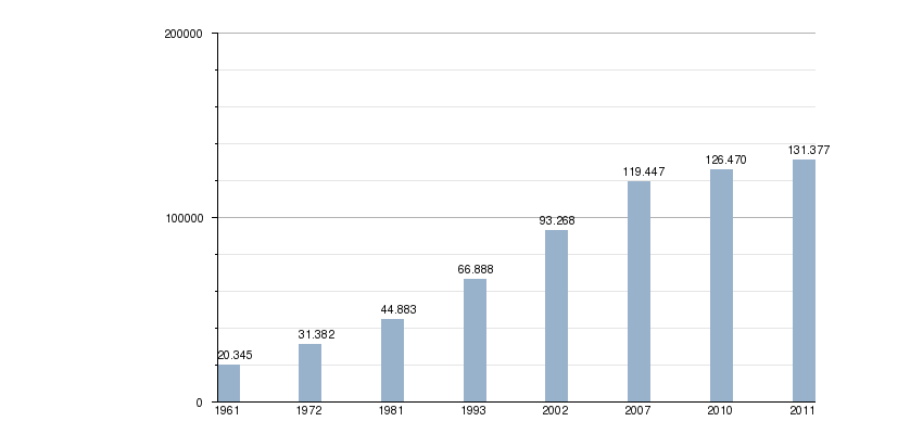
According to the 2007 Peruvian Census, the Metropolitan Area of Huaraz has a population of 119,447. After the earthquake that the city suffered in 1970, a fifty percent of people in the city died, in spite of that, the city was rebuilt and generated a migration wave, especially from rural areas in the region. Finally during the decade of the 1990s, the Pierina gold mine was established in the region, encouraging people from other parts of the country to settle in the city.
The official language in the city is Spanish. It is spoken for the majority of Huaraz citizens. On the other hand, a minority of people speaks Quechua, in rural areas it has more predominance.
- Graphics of population by INEI.
- In the following graphic the grey bars show the evolution of the population of the city since 1961 till 2011.
Economy
Presently, mining is the main economic activity. Since the foundation of Pierina gold mine in 1996, for the Canadian company Barrick Gold Corporation. Industry is composed of medium and small companies dedicated to food industry, as the elaboration of soft drinks, beer, cheeses and milk derivates, and this activity occupies a 13% of the economically active population. Also exist companies dedicated to the building and housing industry. Those kind of companies are spread by different parts of the metropolitan area and Callejón de Huaylas basin.
Fifty percent of economical active population is dedicated to commerce and is service-oriented. Since the 1990s, have been increasing the number of small and medium companies, as a result, of the economical crisis and in order to survive the index of unemployment. Is important to notice that the laboral force of the small managements which impulse other activities as tourism and handicrafts industry. Moreover, Huaraz have ever been the center of business, commerce, and finances in the Callejón de Huaylas and the Andean part of Ancash, as if the city is the main supplier industry of farming products in the Region.
Despite tourism always was the main economic activity, for that reason Huaraz is one of the main tourist destinations of Peru, receiving every year 200,000 visitors between Peruvian and foreigners. Huaraz as main city of the region, has the majority of tourist services like good-quality hotels, restaurants, pubs. Visitors are expected to visit the Huascarán National Park, also known as the biggest glacier in the tropics, and other historical sites as Chavín de Huantar.
Sports and recreation

Soccer is one of the most practiced sports in the city. However its practice has generated more expectives since the club Sport Áncash was the only soccer team in participate at Peruvian Soccer League. inside the city there many soccer courts located in the different neighbourhoods in order to practice this kind of sport. Other sports that are practiced like the basketball and the volleyball, especially in the female people. Moreover, tennis has so much acceptance in the city.
Adventure sports have become very popular in the city with the tourism boom, especially among young people. Popular adventure sports include paragliding, hang gliding, trekking, llama trek, climbing, rafting, canoeing, mountain biking, motocross, abseiling, and puenting. Puenting is practiced from the highest bridge crossing the Santa river. Winter sports are also very popular, including mountaineering, snowboarding, skiing. Peaks surrounding the city in the Huascaran National Park such as Pastururi are popular for climbing. Treks to local peaks Ratakinwa and Pukaventana are also very popular.
Sports

As in all of Peru, soccer is the most popular sport in Huaraz. The Rosas Pampa Stadium is the main site for soccer tournaments like the Peruvian Soccer League. This stadium has a capacity of 20,000. The most representative soccer team in the city is Sport Ancash, the only Huaraz team in participate in Peruvian soccer league.
Other sports are practiced, such as basketball, volleyball and tennis. There are other sport courts like the Coliseum of Huaraz, and many fields dispersed in the city. Adventure Sports is also requeired by lots of Internationals around this area, high qulity organization can be taken with Peru Bergsport in Huaraz http://www.perubergsport.com
Transportation
Roads
Huaraz is connected to the Pacific coast by three highways. One goes generally westward, another goes south then west, and the other goes north then west. All three roads go from the Andes down into the desert coastal region.
The westward route rises into the Cordillera Negra, crests at about 4000 m (ca. 13,100 ft), then winds downward in altitude to the coastal city of Casma on the Pan American Highway. (Casma is the largest population center between the cities of Lima and Chimbote.)
The southward route from Huaraz goes about 40 km toward the town of Recuay, where it turns west. It rises to about 4,300 m (ca. 14,000 ft) where it crests the south part of the Cordillera Negra. From there the narrow winding highway in a distance of about 80 km (ca. 60 miles) descends to the town of Huarmey (south of Casma) on the coast. Here it connects with the Pan-American Highway (187 km north of Lima).
The northward route going north from Huaraz follows the Rio Santa to the north end of the Callejón de Huaylas, where it branches into two. The minor branch goes steeply westward up to the ancient town of Huaylas and then northwestward down to the coast. The main highway goes north beside the Cañón del Pato through a dozen one-lane tunnels, precipitously descends several thousand meters by switch-backs and hairpin curves on the one-lane rocky roadway, and arrives at the town of Huallanca. Here there is a connection with the Santa Railway. The highway again splits. The most heavily traveled fork continues generally west to the coastal city of Chimbote where it connects with the Pan-American Highway. The other fork goes from Huallanca northward and upward into the northern Peruvian Andes.
Travel by vehicle via any of the three highway routes from Huaraz to the coast generally requires seven to eight hours to either Lima or Chimbote.
Public transportation

Huaraz mass transit is operated by private companies authorized by city hall and the Transportation Secretary of Peru. The system includes vans and buses, that has organized routes but in an informal way. People commutes on them or in their private cars. Taxis can be taken in their signed stops, and in comparison to another Peruvian big cities is cheaper but depending of the distance the price can increase. Also there are colectivos (commuter taxis) that has routes similar to buses and can be shared with other passengers in comparison with taxis.
Air transportation
Less than 40 minutes drive north from Huaraz lies the Comandante FAP Germán Arias Graziani Airport located in the village of Anta; the airfield serves small planes from the two largest mining companies in the region as well as small commercial prop-driven aircraft of the regional airline LC Busre.
Tourism


In the city, prairies, forests and snow peaks can be seen from the urban center. But inside Huaraz, there are some tourist sites to visit. At La Soledad, there is the Lord of Soledad Chapel, which contains crucified Christ, that was founded during colony times. Also there are pre-Hispanic ruins, 3 miles from the city in Wilcahuain, where there are stone palaces of Wari culture. Other ruins are located 1 mile from Huaraz in Waullac, surrounded by big prairies with views of snow peaks and mountains.
At downtown across from the Plaza de Armas (main Square) is located the Museum of Ancash, which contains a lot of value pieces of the Recuay culture, and in this museum there is the Monolithic Park, which is considered one of the largest in America.
There is plenty of volunteering opportunities in Huaraz especially with the organisation 'Teach Huaraz'. This program is set up by a local teacher, allowing international volunteers to teach English and Computing, where full accommodation and food is provided. Check out https://www.facebook.com/TeachHuarazPeru/ for more information. 8 miles north from Huaraz, the Monterrey Baths are located, which contain hot springs with medical properties, and also is a so ecological place surrounded by forests, where there are lodges and some upscales hotels.
Huaraz is the touristic operation center of the region, drawing thousands of visitors that practice adventure and winter sports. Also, Huascarán National Park, which is considered a biosphere reserve, is a popular destination for tourists.
The peaks of the region have for many decades been the testing grounds for mountain climbers anticipating future expeditions into the Himalayas. Huaraz is a popular base for expeditions into the Cordillera Blanca and the Waywash mountain range south of the Callejón del Huaylas.
In the streets surrounding the farmers' market, the paraditas (street markets) of local sellers offer handicraft products such as ponchos, alpaca textiles (carpets, sweaters, etc.); jewelry made of locally mined tin, copper, and silver; cuarteados (a typical dessert from the nearby town of Caraz made by mixing manjarblanco and fruit cake); boxes of manjarblanco, butter, cheese, honey, smoked and salty hams, jerky (Quechua charqui), etc.
Huaraz is known as the 'Switzerland of the South' because of its beautiful peaks that are visible from the city centre.
The Pre-Inca trail trekking is most popular in the region, featured by its stone paved trail that leads to Chavin, and another particular featured is because using Lamas for packing while on trekking, inquires to local community cooperating with responsible travel refer to Peru Llama Trek http://www.perullamatrek.com
Culture
Museum and the arts
Huaraz is home to some museums. Across from Main Square is located the Archaeological Museum of Ancash. This museum presents three levels divided in four rooms, and in each one, there is an exhibition of cultural manifestations made by the different human groups have inhabited the Ancash Region. At this museum there is the Monolithic Park, that is considered the biggest stone park in South America.
Huaraz also is home of the Cultural Center of Huaraz that became a new arts hub. It opened in 2012 and it is considered one of the biggest theaters of Peru.
Cuisine
The cuisine of Huaraz is considered to be one of the most recognized in the Peruvian Andes. Among the most popular dishes are Picante de Cuy (a roasted guinea pig in a sauce of red spices, served with bold potatoes), Llunca de gallina (a chicken soup prepared with bold wheat and yellow spices), Charqui de Chancho and res (roasted pork and beef salted and dried), Pachamanca (a dish prepared on the ground with hot stones, made of different kind of meats as beef, chicken, pork with baked corn and potatoes), Pataska (a hot soup, made with boiled corn and pork or beef skin), Ceviche and Chocho (raw fish marinated in lemon juice served with chocho, a typical cereal), the Jamón Huaracino (salty and dried ham). There are some desserts like Api de Calabaza (sweet cream made of mashed pumpkin) and beverages, such as Chicha de Jora (sour yellow corn).
Media
Huaraz has many local newspapers and three local television channels that run in the early morning. Most media organizations are located around the main square in the Municipality of Huaraz and share information during the day. Governmental information comes from the office Imagen. There are many printing companies, most specialize in business cards and leaflets. You can find them crossing the bridge towards Centenario or on Gamarra Street. The national post service, can be found on the Plaza de Armas. Channel three and thirteen are the local TV channels that operate in the morning.
Newspapers
Most national newspapers as El Comercio, Peru 21 and Correo can be purchased early in the morning as those are flown in from Lima. Among the newspapers published in the city of Huaraz; one is Diario Ya,[4] another newspaper is Prensa Regional.[5]
English language newspaper
Since the beginning of April 2012, Huaraz also has a free English language newspaper called The Huaraz Telegraph, read by students of the language schools and tourists.[6]
See also
References
- ↑ Perú: Población estimada al 30 de junio y tasa de crecimiento de las ciudades capitales, por departamento, 2011 y 2015. Perú: Estimaciones y proyecciones de población total por sexo de las principales ciudades, 2012-2015 (Report). Instituto Nacional de Estadística e Informática. March 2012. Retrieved 2015-06-03.
- 1 2 3 Municipalidad de Huaraz. Urban Characteristics (2011). Retrieved on 2012-08-24.
- ↑ http://www.munihuaraz.gob.pe/muni2/index.php?option=com_content&view=article&id=541[]
- ↑ http://www.diario-ya.com
- ↑ http://www.invierteenhuaraz.com.pe/prensa/
- ↑ http://thehuaraztelegraph.com
External links
| Wikimedia Commons has media related to Huaraz. |
-
 Huaraz travel guide from Wikivoyage
 - Official website
Coordinates: 9°32′S 77°32′W / 9.533°S 77.533°W