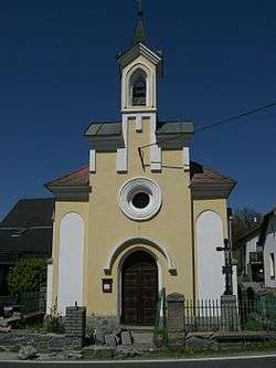
Hrejkovice
| Hrejkovice | |||
|---|---|---|---|
| Municipality | |||
 | |||
| |||
 Hrejkovice | |||
| Coordinates: 49°28′25″N 14°17′29″E / 49.47361°N 14.29139°ECoordinates: 49°28′25″N 14°17′29″E / 49.47361°N 14.29139°E | |||
| Country |
| ||
| Region | South Bohemian | ||
| District | Písek | ||
| Area | |||
| • Total | 13.39 km2 (5.17 sq mi) | ||
| Elevation | 471 m (1,545 ft) | ||
| Population (2011) | |||
| • Total | 487 | ||
| • Density | 36/km2 (94/sq mi) | ||
| Postal code | 398 59 | ||
| Website | http://www.hrejkovice.cz | ||

Hrejkovice is a village and municipality (obec) in Písek District in the South Bohemian Region of the Czech Republic.
The municipality covers an area of 13.39 square kilometres (5.17 sq mi), and has a population of 457 (2005).
Hrejkovice lies approximately 23 kilometres (14 mi) north-east of Písek, 57 km (35 mi) north of České Budějovice, and 69 km (43 mi) south of Prague.
References
| Wikimedia Commons has media related to Hrejkovice. |
This article is issued from Wikipedia - version of the 4/7/2016. The text is available under the Creative Commons Attribution/Share Alike but additional terms may apply for the media files.