Hout Bay Museum
 Hout Bay Museum | |
| Established | 5 April 1972 |
|---|---|
| Location | Hout Bay, Cape Town, South Africa[1] |
| Coordinates | 34°02′25″S 18°21′36″E / 34.040278°S 18.36°ECoordinates: 34°02′25″S 18°21′36″E / 34.040278°S 18.36°E |
| Type | History museum |
| Director | Western Cape Government |
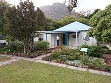
Hout Bay Museum is a province-aided museum on 4 Andrews Road in Hout Bay near Cape Town, South Africa. Opened on 5 April 1979. The museum has displays on the history of the Hout Bay valley and its people, focusing on forestry, mining, and the fishing industry up to modern times. The museum also organizes weekly guided nature walks into the surrounding mountains. The first curator at Hout Bay Museum was Pam Wormser.
Museum history
Jimmy Steele, a retired official of the Museum’s Section, Department of Nature Conservation, had nurtured for many years the dream of founding a museum in Hout Bay. In 1975, a Cultural Arts Festival was held in the Bay. Apart from exhibitions by local craftsmen, musical and drama presentations, exhibitions on the history of Hout Bay were held - the Strandlopers, early Hout Bay residents, and the shipwrecks along our coast. This festival proved that Hout Bay had a fascinating history and it was important that a permanent home be found where all this information and artifacts belonging to our past could be preserved for the future.

Jimmy Steele was Chairman of the Festival Committee and at the Report Back Meeting at the end of the festival, it was proposed that he go ahead with negotiations to found a museum. With the backing of the Ratepayers Association he approached the Divisional Council of the Cape for the financial assistance and leased part of Kronendal School for the nominal fee of R1 per annum. The following chronology of dates and events portray the development of the museum.
11 July 1977. A grant of R8 500 per annum was finally agreed upon. In 1978, A report on how to renovate and develop the building suitable as a museum was drawn up by Mr E Hayden, Chief Technician for Museums. The Hout Bay/Llandudno Round Table undertook to alter and repair the building, which incidentally, had originally been built as a house for the Headmaster of Kronendal School.
August 1978. Pam Wormser was appointed as first Curator of the museum, and a special committee was appointed consisting of Jimmy Steele as Chairman; Dr R Borchers and Mrs E Bisschop as members of the committee.
1 September 1978. The first meeting was held. The initial task was to aim for Provincial recognition, then a Board of Trustees of six members would be appointed two to represent CPA, two the Divisional Council and two the subscribers to the museum.
25 October 1978. A lecture by Townley Johnson on the Strandlopers launched the appeal to start this Society. The museum’s application for membership to the South African Museums Association was approved.

At the end of 1978 the museum had a furnished office, showcases and a host of artefacts and memorabilia from the farms, wrecks of the immediate area fishing paraphernalia. The early days of the museum were spent in furnishing the museum. Mr & Mrs Fuller Gee, qualified landscape architects, designed the layout of the garden, but work on the garden only commenced in 1979 after the formal opening of the Museum on 5 April.
In November 1979 Provincial recognition was granted and the Museum was declared a Local History Museum. And now many years later the Hout Bay Museum continues to play an important role in education in hosting schools from all over the Peninsula. It holds exhibits and protects a wealth of information, records and photographs of local interest.


History of Hout Bay
Thousands of years ago primitive man lived in Hout Bay. From the remains found in a cave we know that people lived in this cave between 100 ad and 500 ad. These people were known as the late Stone Age people. They had no metal tools or weapons and used stone to make whatever implements they needed. They were gathers of wild plants, shellfish and the seabirds and animals that were washed ashore. They also hunted and fished using Hooks fashioned from Bones and nets made from fibrous plants and the skins of animals.
The Khoi-Khoi and Bushmen were descendants of the late Stone Age people. They were called Khoi-Khoi because of the strange clicking sound of their language. The Khoi-Khoi were also called Strandlopers because they gathered food from the beaches and some people called them Kaapmans, Men from the Cape. Harry could speak a little English and was a great help to Van Riebeeck as an interpreter. The Khoikhoi were gatherers, hunters and Herders this means that apart from gathering and hunting their food they also possessed large herds of cattle and sheep. They lived in huts made of restio mats tied to a Beehive shape frame made of pliable poles. The Khoi often set up camp in Hout Bay. The names Hotnotshuisie and Oudekraal originated from the days when the Khoi camped in these places. The Khoi traded with the early voyagers from Europe who were on their way to the East and had stopped at the Cape in order to get fresh food and water. The Khoi bartered with these early sailors exchanging cattle and sheep for small pieces of copper, brass and tin.

The first written account of Hout Bay dates to 1607 when John Chapman, masters mate on the English boat, the "Consent" which was becalmed at the entrance to the Bay, was sent in the ship’s pinnace at dusk on a chancy venture because Hout Bay was unknown wild country and the time was late afternoon which would make it difficult for him to find the Consent in the darkness.
Recorded in the Rutter (Logbook) by the pilot, John Davis: "Chapman’s Chaunce hath in latitude 34-10 and is a harbour which Leith within the south west point under a little hill like charring cross (a sculptured memorial of a cross on a ornamental mounting in London) close hanging by the sea- side of the S.S.W side of the land " Chapmans Chaunce was the first name given to Hout Bay and it was also the first English name to appear on the maps of Southern Africa.
In 1614 an English sailor records having taken wood from the forest of Hout Bay in order to mend his ship.
In 1652 Jan Van Riebeeck landed at the Cape and it wasn’t long before he visited Hout Bay. He describes the forest of Hout Bay as being the finest in the world. It was Van Riebeeck who gave Hout Bay its present name. In 1652 on 22 November Van Riebeeck wrote in his journal about T’ HOUTBAAITJEN. Since then it has been known as Hout Bay.
In 1662 the year when Jan Van Riebeeck left the Cape, the Boscheuwel road was extended from Kirstenbosch in a rough track over Constantia Nek to Hout Bay.
In 1668 the first permit to cut and saw wood in the Hout Bay forest was granted. In 1677 the first agreement to rent land for farming purposes was signed. In 1681 two farms were established Ruyteplatts and Kronendal.
The Forts
In 1781 the French built 3 forts at Hout Bay. These were part of a line of Forts known as the French lines that were built in order to protect the Cape from falling into the hands of the English. The west fort at the harbour dates from this time. In the latter half of the 19th Century the farms Moddergat, Nooitgedacht, Oakhurst and Uitkyk were established.
 Fort Klein Gibraltar
 East Fort of today
 East Fort of old
The Manganese Mine
In 1873 Manganese was discovered in the Constantiaberg. In 1909 to 1911 Manganese was mined in Hout Bay. Reminders of these activities are the ruins of the manganese ore Jetty and the old mine workings up on the mountains. In 1880 Crisp Arnold setup fishing sheds and started curing snoek for export to Mauritius.

St. Peter's the Fisherman church
In 1895 Walter Gurney built the first church in Hout Bay. It still stands today and is known as St Peter’s the Fisherman. The first school in Hout Bay was started in this church.
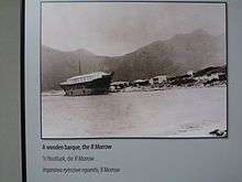
The R Morrow - Factory Boat
In 1904 Hout Bay first crawfish canning factory was established in the wreck of an old sailing ship, The R Morrow that stood where the present South African Sea Products factory stands today. For almost 10 Years the factory operated successfully exporting canned crawfish overseas and providing work for the local inhabitants. On 31 July 1914 a leak in the acetylene gas supply caused an explosion which blew up the canning factory killing 7 people including the owner Mr. Lucien Plessis.
Chapman's Peak
In 1922 Chapman's Peak drive was opened to the public. It had been built by the provincial administration using convict labour. It had taken 7 years to build and had cost (R40 000).

The Fishing Industry
The fishing industry expanded substantially in the 1930s when fish became a popular item on menus and improved facilities for transporting fish inland were created. The Trautman family improved their fishing boats and built more sheds on the beach for processing the fish. They owned Trans Africa Fisheries. The Trautman brothers introduced the valuable frozen rock lobster tail export business and the Dorman family who like the Trautmans had originally bought land in the 19th Century for farming purposes became more involved in the fishing industry. Duikersklip and Chapman’s Peak Fisheries were two companies owned by the Dormans.
Today Chapman’s Peak fisheries have expanded to incorporate a fish importing business as well as retailing local catches. Mariners Wharf South Africa’s fish emporium was opened 1984.
Harbour facilities have improved steadily over the years. In 1937 the south Breakwater was built and in 1968 the North Breakwater was added. The post war fishing factories spreading everywhere and at Hout Bay the South African Sea Products Company was formed.
The Hotels
Holiday accommodation the Hout Bay Hotel was built sometime between 1871 and 1889 by Jacob Trautman. Originally known as the Royal Hotel it was a popular honeymoon hotel at the return of the century.
Chapman’s Peak hotel was originally called the Beach Hotel and was built in 1903 after the original hotel burnt down. It was a beautiful example of an Edwardian seaside Hotel until 1981 when extensive alterations were embarked upon.
Flora Bay
Flora Bay bungalows a favourite camping site for many years before Flora Bay were developed. A large sandy beach, which linked up, with the main beach covered the rocks below this area. The sand slowly disappeared when the breakwater quays were built on the west side of the bay in 1937. A small beach was still there in the 1960s.
University of Cape Town students camped here in the 1920s. The girls were accompanied by a chaperone and camped under the milkwoods on the one side of the bay whilst the boys' camp was set up on the other side. Campers increased to such an extent, especially over Christmas and Easter that Ernest Trautman employed a small measure of control by charging a small camp fee in the 1940s. Later he built Rondawels with thatched roofs and today the little bay has accommodation for 130.
Further reading
- Tony Westby-Nunn: Hout Bay - An illustrated profile
- Stanley Dorman: Embracing Hout Bay - Edited by Gwynne Schrire
- Carey-Ann van der Bijl and Sue Maude: The life of Llandudno
References
- ↑ "Hout Bay Museum". westerncape.gov.za. Retrieved 26 May 2014.
| Wikimedia Commons has media related to Hout Bay Museum. |