Houston, Missouri
| Houston, Missouri | |
|---|---|
| City | |
|
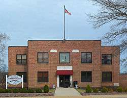
Texas County Administrative Center | |
 Location of Houston, Missouri | |
| Coordinates: 37°19′24″N 91°57′35″W / 37.32333°N 91.95972°WCoordinates: 37°19′24″N 91°57′35″W / 37.32333°N 91.95972°W | |
| Country | United States |
| State | Missouri |
| County | Texas |
| Government | |
| • Mayor | Don Tottingham |
| Area[1] | |
| • Total | 3.64 sq mi (9.43 km2) |
| • Land | 3.64 sq mi (9.43 km2) |
| • Water | 0 sq mi (0 km2) |
| Elevation | 1,165 ft (355 m) |
| Population (2010)[2] | |
| • Total | 2,081 |
| • Estimate (2012[3]) | 2,084 |
| • Density | 571.7/sq mi (220.7/km2) |
| Time zone | Central (CST) (UTC-6) |
| • Summer (DST) | CDT (UTC-5) |
| ZIP code | 65483 |
| Area code(s) | 417 |
| FIPS code | 29-33238[4] |
| GNIS feature ID | 0735656[5] |
| Website | City of Houston, Missouri |
Houston is a city in Texas County, Missouri, United States. The population was 2,081 at the 2010 census. It is the county seat of Texas County.[6]
Geography
Houston is located at 37°19′24″N 91°57′35″W / 37.32333°N 91.95972°W (37.323390, -91.959775).[7] According to the United States Census Bureau, the city has a total area of 3.64 square miles (9.43 km2), all of it land.[1] Houston is the second largest city in Texas County, behind Cabool.
Demographics
| Historical population | |||
|---|---|---|---|
| Census | Pop. | %± | |
| 1880 | 191 | — | |
| 1890 | 355 | 85.9% | |
| 1900 | 514 | 44.8% | |
| 1910 | 644 | 25.3% | |
| 1920 | 772 | 19.9% | |
| 1930 | 690 | −10.6% | |
| 1940 | 820 | 18.8% | |
| 1950 | 1,277 | 55.7% | |
| 1960 | 1,660 | 30.0% | |
| 1970 | 2,178 | 31.2% | |
| 1980 | 2,157 | −1.0% | |
| 1990 | 2,118 | −1.8% | |
| 2000 | 1,992 | −5.9% | |
| 2010 | 2,081 | 4.5% | |
| Est. 2015 | 2,082 | [8] | 0.0% |
2010 census
As of the census[2] of 2010, there were 2,081 people, 935 households, and 513 families residing in the city. The population density was 571.7 inhabitants per square mile (220.7/km2). There were 1,060 housing units at an average density of 291.2 per square mile (112.4/km2). The racial makeup of the city was 96.3% White, 0.2% African American, 0.6% Native American, 0.4% Asian, 0.5% from other races, and 1.9% from two or more races. Hispanic or Latino of any race were 1.2% of the population.
There were 935 households of which 28.4% had children under the age of 18 living with them, 37.4% were married couples living together, 13.6% had a female householder with no husband present, 3.9% had a male householder with no wife present, and 45.1% were non-families. 41.0% of all households were made up of individuals and 21.2% had someone living alone who was 65 years of age or older. The average household size was 2.08 and the average family size was 2.78.
The median age in the city was 41.9 years. 21.7% of residents were under the age of 18; 8.4% were between the ages of 18 and 24; 22.3% were from 25 to 44; 22.7% were from 45 to 64; and 24.7% were 65 years of age or older. The gender makeup of the city was 44.0% male and 56.0% female.
2000 census
As of the census[4] of 2000, there were 1,992 people, 904 households, and 536 families residing in the city. The population density was 559.8 people per square mile (216.0/km²). There were 1,042 housing units at an average density of 292.8 per square mile (113.0/km²). The racial makeup of the city was 96.13% White, 0.20% African American, 0.80% Native American, 0.30% Asian, 0.35% from other races, and 2.21% from two or more races. Hispanic or Latino of any race were 1.46% of the population.
There were 904 households out of which 25.3% had children under the age of 18 living with them, 43.6% were married couples living together, 12.3% had a female householder with no husband present, and 40.6% were non-families. 37.7% of all households were made up of individuals and 22.6% had someone living alone who was 65 years of age or older. The average household size was 2.07 and the average family size was 2.67.
In the city the population was spread out with 20.7% under the age of 18, 7.4% from 18 to 24, 22.2% from 25 to 44, 22.3% from 45 to 64, and 27.4% who were 65 years of age or older. The median age was 45 years. For every 100 females there were 73.7 males. For every 100 females age 18 and over, there were 69.1 males.
The median income for a household in the city was $20,886, and the median income for a family was $28,798. Males had a median income of $26,371 versus $17,500 for females. The per capita income for the city was $14,977. About 20.6% of families and 26.2% of the population were below the poverty line, including 34.9% of those under age 18 and 19.8% of those age 65 or over.
History
Houston was founded in 1857.[10] It was named for Sam Houston.[11][12]
During the American Civil War, Houston was sometimes manned by units of the 5th Missouri State Militia. [13]
References
- 1 2 "US Gazetteer files 2010". United States Census Bureau. Retrieved 2012-07-08.
- 1 2 "American FactFinder". United States Census Bureau. Retrieved 2012-07-08.
- ↑ "Population Estimates". United States Census Bureau. Retrieved 2013-05-30.
- 1 2 "American FactFinder". United States Census Bureau. Retrieved 2008-01-31.
- ↑ "US Board on Geographic Names". United States Geological Survey. 2007-10-25. Retrieved 2008-01-31.
- ↑ "Find a County". National Association of Counties. Retrieved 2011-06-07.
- ↑ "US Gazetteer files: 2010, 2000, and 1990". United States Census Bureau. 2011-02-12. Retrieved 2011-04-23.
- ↑ "Annual Estimates of the Resident Population for Incorporated Places: April 1, 2010 to July 1, 2015". Retrieved July 2, 2016.
- ↑ "Census of Population and Housing". Census.gov. Retrieved June 4, 2015.
- ↑ Ramsay, Robert L. (1952). Our Storehouse of Missouri Place Names. University of Missouri Press. p. 26.
- ↑ Eaton, David Wolfe (1918). How Missouri Counties, Towns and Streams Were Named. The State Historical Society of Missouri. p. 367.
- ↑ Gannett, Henry (1905). The Origin of Certain Place Names in the United States. Govt. Print. Off. p. 161.
- ↑ Hewett, J. (1994). Supplement to the Official records of the Union and Confederate Armies. Wilmington, NC: Broadfoot Pub. Co. , Volume 35, p. 136
External links
- Historic maps of Houston in the Sanborn Maps of Missouri Collection at the University of Missouri
Municipalities and communities of Texas County, Missouri, United States | ||
|---|---|---|
| Cities | 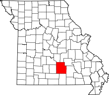 | |
| Villages | ||
| Townships |
| |
| Unincorporated communities | ||
| Footnotes | ‡This populated place also has portions in an adjacent county or counties | |