Houghton Regis
| Houghton Regis | |
 High Street |
|
 Houghton Regis |
|
| Population | 17,280 (est.)[1] 17,283 (2011 Census)[2] |
|---|---|
| Unitary authority | Central Bedfordshire |
| Ceremonial county | Bedfordshire |
| Region | East |
| Country | England |
| Sovereign state | United Kingdom |
| Post town | DUNSTABLE |
| Postcode district | LU5 |
| Dialling code | 01582 |
| Police | Bedfordshire |
| Fire | Bedfordshire and Luton |
| Ambulance | East of England |
| EU Parliament | East of England |
| UK Parliament | South West Bedfordshire |
|
|
Coordinates: 51°54′14″N 0°31′29″W / 51.9039°N 0.5247°W
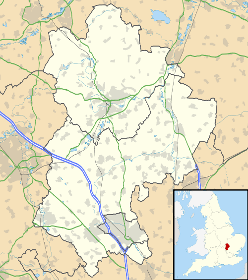
Houghton Regis /ˈhaʊtən ˈriːdʒᵻz/ is a town and civil (administrative) parish contiguous to the larger town of Dunstable to the south. Its parish council provides certain sports and open space amenities and includes the ancient hamlets of Bidwell, Thorn, and Sewell. Houghton Regis, along with its near neighbours of Dunstable and Luton form the Luton/Dunstable Urban Area, with a population over 255,000.[3]
Ancient history
Relics of Palæolithic man, such as flint implements and the bones of contemporary wild animals, suggest prehistoric settlement. At Maiden Bower within Houghton Regis CP, near Sewell, there is an Iron Age hill fort. This is clearly marked on the Ordnance Survey maps.

Maiden Bower has some of the ramparts showing through the edge of an old chalk quarry[4] where there are Bronze Age remains of an older Fort. According to W.H. Matthews (Mazes and Labyrinths, 1922), a turf maze once existed at "Maiden Bower".[5]
The Icknield Way Path passes through the parish on its 110 mile journey from Ivinghoe Beacon in Buckinghamshire to Knettishall Heath in Suffolk. The Icknield Way Trail, a multi-user route for walkers, horse riders and off-road cyclists also passes through the parish.
History
Houghton Regis is considerably older than Dunstable, and it is mentioned in the Domesday Book when it was called Houstone.[6] At the time of the Domesday Survey a great part of what is now Dunstable was included in Houghton parish. When Henry I founded Dunstable he gave in compensation to the men of Houghton a wood called Buckwood.[7] At that time it paid in tax the large amount of three pounds by weight and twenty shillings of blanch silver (to the King) and one ounce of gold for the Sheriff.[8] Timeline for Houghton Regis.[9]
The men of Houghton claimed to be exempt from tolls in Dunstable market.[10] The inhabitants of Houghton Regis were for long employed in straw-plaiting. In 1689 they and those of neighbouring villages petitioned against the Bill that made it compulsory to wear woollen hats, pointing out that the straw-plaiters would be ruined and that the farmers also would suffer, as they now obtained good prices for their straw, and English wool not being suitable for hatmaking, they would not be in any way compensated.[7]

Bordered by the Chiltern Hills, the town was once a small village that had its character changed when it was earmarked for a massive "London overspill" estate in the 1950s and 60s. The only remains of the manors, rectory land and cottage demesnes around the small village centre are names such as Tithe Farm Road. An indication of the planners' attempts to make the London migrants feel at home is the naming of the local estate roads after London landmarks; Chelsea Gardens is an example.
Remnants of the town's past are still apparent with, for example, the fifteenth century Parish Church of All Saints (formerly St Michaels) with an excellent example of a Norman tower[11] and the former Squire's residence of Houghton Hall, built in the eighteenth century.
Between the late 1960s and the early 1970s, many of the High Street shops were demolished along with a chapel to make way for industrial units, many of which have since been demolished themselves. The main shop in town was a Wavy Line store, which has since been used as a motorbike and car showroom. A fish and chip shop, Tansley's, was at the entrance to what was the access road into the Co-op Store; the current fish and chip shop on Bedford Road was previously occupied by Georges, a tobacconist and confectioner but in the early 1900s was a public house. In front of the existing closed All Saints Parish Church graveyard, facing onto the High Street, was a row of cottages, once the workhouses complete with village lock-up at the end of the terrace. The White House, the home of a Miss Freeman, a school teacher and aunt of Gary Cooper, plus Jasper Perry's green grocer and Birds bakery stood on the opposite side of the road.
Economy
The Townsend Industrial Estate,[12] built on the former farm of the same name includes the roads of Townsend Farm Road, Portland Close, Blackburn Road, and Westbury Close. To the south of Houghton Hall Park is the Houghton Hall Business Park.[13] Located here are Whitbread, Aldwyck Housing Group, NICEIC Group, Renault Trucks (UK), BRS, ArjoHuntleigh Group. To the south east of this estate is the Lovett Way Woodside estate.[14] Businesses located here include Disability Resource Centre, Centrebus, Hermes, DPD, Premier Cables.
The Co-op store was destroyed by fire in June 2006.[15] The store later re-opened on a smaller footprint, but was closed down in 2014, and demolished in 2015.[16] A Morrisons medium-sized supermarket opened in 2012.[17] A Tesco Express store in Bedford Square shopping centre closed in March 2015.[18] GOHoughton restaurant and bar opened on 18 May 2015.[19]
Modern times
Houghton Regis Town Council organises several regular free events every year. These include Pancake Race, Easter Egg Hunt, May Fayre, Carnival, Classic and Vintage Car Show.[20]
The Greenway and the route through Dunstable and Houghton Regis forms part of National Route 6 of the National Cycle Network. This provides walking and cycling routes between Milton Keynes, Luton and London.[21]
Central Bedfordshire Council allowed Stevenage Leisure Limited (who operate the Houghton Regis Leisure Centre as Lifestyles (@) Houghton) to carry out major renovation.[22]
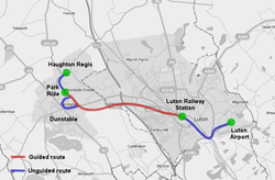
The Luton-Houghton Regis guided Busway (route pictured) opened in 2013,[23] costing in the region of £62 million.[24]
Education
Primary schools in the town include Hawthorn Park Community Primary School,[25] Houghton Regis Primary School,[26] St Vincent's RC Primary School,[27] Thomas Whitehead CE Primary School,[28] Thornhill Primary School[29] and Tithe Farm Primary School.[30] Secondary schools serving the area include Houghton Regis Academy,[31] All Saints Academy[32] and UTC Central Bedfordshire. The Chiltern School is a special school which also has a campus in Houghton Regis.
Central Bedfordshire College has a campus in Houghton Regis which offers a range of further education courses.[33]
Plans for the area
A5-M1 Link (Dunstable Northern Bypass)
|
The route of the Dunstable Northern Bypass proposal and route options for the connecting Luton Northern Bypass. | |
| Location | Central Bedfordshire |
|---|---|
| Proposer | Highways Agency |
| Status | Approved |
| Type | Road |
| Cost estimate | £171 million to £217 million |
| Start date | 2014–2015 |
| Completion date | 2016–2017 |
| Geometry | KML |
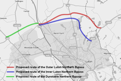
The A5-M1 Link (Dunstable Northern Bypass) is to be a two-lane dual carriageway running east from the A5 north of Dunstable to join the M1 at a new Junction 11a south of Chalton.[34] Here, it is intended to join with a proposed Luton Northern Bypass to form a northern bypass for the wider conurbation. The A5-M1 Link aims to alleviate traffic congestion in Houghton Regis and Dunstable, reduce journey times for long-distance traffic travelling through Dunstable and improve the regional economy. The Highways Agency is expected to detrunk the A5 through Dunstable when the A5-M1 Link opens to the public in early 2017.[35]
Woodside Link
The 2.9 km A5505 Woodside Link is to connect the industrial areas of Dunstable and Houghton Regis to the new junction 11a of the M1 motorway.[36] It will take traffic out of the town centres, reduce congestion and improve air quality. Forming part of Central Bedfordshire Council's Dunstable Town Centre Masterplan,[35] the Woodside Link aims to improve job opportunities and quality of life for people living and working in Dunstable and neighbouring towns and villages. It will also provide access to a new development area north of Houghton Regis, where 5,600 new homes are to be built and 30 hectares of employment land are to be developed by 2031.[37] Central Bedfordshire Council is delivering the £38.3m scheme with contributions of £20m from SEMLEP's Local Growth Deal,[38] £5m from the UK government's Local Pinch Point Fund[39] and £1m of developer contributions. Construction started in spring 2015 and the Woodside Link is due to open to traffic in autumn 2016.
Houghton Regis North Framework Plan
This plan includes a proposed north of Houghton Regis urban extension of 6,950 homes and 83 ha of employment land by 2026 with potential for a further 4,050 homes and 17 ha employment land. In addition, further development is proposed within the existing urban area.[40] (for the reference link, scroll to item 8 of the agenda). Within the Framework Plan, the Houghton Regis Development Consortium are planning for 5,150 homes, employment, retail, infrastructure, community, facilities and leisure on cultivated farmland north of Tithe Farm estate and to the east of Parkside estate.[41]
Politics
Houghton Regis Town Council[42] has 14 elected councillors who receive no remuneration. Elections are held every 4 years.
Central Bedfordshire came into being on 1 April 2009. The first-ever elections for Central Bedfordshire took place on 4 June, when the three wards of Houghton Regis were won by the Liberal Democrats.[43]
See also
References
- ↑ Houghton Regis Town Council.
- ↑ "Civil Parish population 2011". Neighbourhood Statistics. Office for National Statistics. Retrieved 5 November 2016.
- ↑ Luton Population Archived 26 February 2007 at the Wayback Machine.
- ↑ "Totternhoe Quarries". Disused Stations. Retrieved 11 August 2014.
- ↑ "Mazes and Labyriths: Chapter XI. Turf Labyrinths (continued)". Sacred-texts.com. 5 April 1920. Retrieved 11 August 2014.
- ↑ Domesday Book: A Complete Translation. London: Penguin, 2003. ISBN 0-14-143994-7 p.1361
- 1 2 "Parishes – Houghton Regis | A History of the County of Bedford: Volume 3 (pp. 389–394)". British-history.ac.uk. 22 June 2003. Retrieved 11 August 2014.
- ↑ Domesday Book: A Complete Translation. London: Penguin, 2003. ISBN 0-14-143994-7 p.563
- ↑ Timeline for Houghton Regis: http://houghtonregisheritage.blogspot.co.uk/p/timeline.html
- ↑ Ann. Mon. (Rolls Ser.), iii, 377
- ↑ Archived 14 April 2013 at the Wayback Machine.
- ↑ "Google Maps".
- ↑ "Google Maps".
- ↑ "Google Maps".
- ↑ "BBC NEWS - UK - England - Beds/Bucks/Herts - Huge blaze guts Co-op superstore".
- ↑ "Demolition Starts on Former Co-op Store #hrcoopbuild".
- ↑ "New Morrisons brings 300 jobs". 10 November 2012.
- ↑ "Tesco Express in Houghton Regis one of 43 stores to close in cost cutting exercise". 28 January 2015.
- ↑ "GoHoughton (@gohoughton) - Twitter".
- ↑ "Community Events - Houghton Regis Town Council".
- ↑ "Route 6 - Map".
- ↑ "Houghton Regis Leisure Centre". Retrieved 4 June 2015.
- ↑ "Busway". Retrieved 25 November 2014.
- ↑ "BBC News article".
- ↑ "Hawthorn Park Community Primary School". Hawthornparkcps.co.uk. 29 April 2014. Retrieved 11 August 2014.
- ↑ "Houghton Regis Primary School". Houghtonregis.beds.sch.uk. 27 May 2014. Retrieved 11 August 2014.
- ↑ "St. Vincent's Catholic Primary School | Hammersmith Gardens, Houghton Regis, LU5 5RG". Stvincentshr.org. Retrieved 11 August 2014.
- ↑ "Thomas Whitehead CE Primary School – Home". Thomaswhitehead.co.uk. Retrieved 11 August 2014.
- ↑ "Thornhill Primary School – Home". Thornhill-primary.co.uk. Retrieved 11 August 2014.
- ↑ "Home | Tithe Farm Primary School". Tithefarmprimary.co.uk. Retrieved 11 August 2014.
- ↑ "Home | Houghton Regis Academy". houghtonregisacademy.org. Retrieved 20 June 2015.
- ↑ "Home &124; All Saints Academy". allsaintsacademydunstable.org/. Retrieved 20 June 2015.
- ↑ "Campuses". Centralbeds.ac.uk. Retrieved 11 August 2014.
- ↑ "A5-M1 Link (Dunstable Northern Bypass)". Retrieved 25 November 2014.
- 1 2 "Dunstable Town Centre Masterplan". Retrieved 25 November 2014.
- ↑ "Woodside Link road". Retrieved 25 November 2014.
- ↑ "Houghton Regis North Site 1". Retrieved 25 November 2014.
- ↑ "SEMLEP awarded £64.6 million Local Growth Deal". Retrieved 25 November 2014.
- ↑ "Successful schemes to be funded in Tranche 2 of the Local Pinch Point Fund" (PDF). Retrieved 25 November 2014.
- ↑ Auth. "Agenda for EXECUTIVE on Tuesday, 2 October 2012, 9.30 a.m. – Central Bedfordshire Council". Centralbedfordshire.gov.uk. Retrieved 11 August 2014.
- ↑ HRN1 (4 September 2013). "HRN1". HRN1. Retrieved 11 August 2014.
- ↑ "Houghton Regis Town Council". Houghtonregis-tc.org.uk. 5 August 2014. Retrieved 11 August 2014.
- ↑ Archived 13 December 2009 at the Wayback Machine.
External links
- Houghton Regis Town Council official site
- Google people and place name map for Houghton Regis
- Picture the Past ~ HOUGHTON REGIS BYGONES
- Stevenage Leisure Ltd
England Portal | |
| Unitary authorities | |
| Major settlements | |
| Topics |
|