Houghs Neck

Houghs Neck /ˈhaʊz/ is a one-square-mile (2.6 km2) peninsula in Quincy, Massachusetts. It is surrounded by Quincy Bay, Hingham Bay and Rock Island Cove. It is lined by Perry Beach, which runs along Manet Avenue; Nut Island, which is just beyond Great Hill at the very end of the peninsula; and Edgewater Drive.
Houghs Neck is commonly referred to by locals as "The Neck," or "God's Country" and its residents as "Neckahs" ("Neckers") or "Neck Birds".[1]
The Hough's Neck Pumping Station (or the "Pumpy" by the locals) is also part of the Boston Harbor Islands, along with Racoon Island, which can be walked to at low tide. Raccoon Island covers .3 sq. miles.
In 1778, founding father John Adams left for a diplomatic mission to France from Houghs Neck instead of Boston, to evade capture by the British.
History
Houghs Neck is named for Atherton Hough, previously mayor of Boston, England,[2] who was granted the land in 1636 as a farm and orchard.[3] The neighborhood's elementary school is also named for Atherton Hough. The peninsula has been called the "flounder capital of the world" and once had six boat rental businesses geared toward catching the bottom dwelling winter flounder that spent the cold weather months in Boston Harbor.[4] Due to its proximity to Boston and its coastline, it was considered a summer resort from the late 19th century well into the 20th[5] Currently, Houghs Neck is a thickly settled neighborhood.[6]
Transportation
Sea Street and Manet Avenue are major thoroughfares in the neighborhood. The Massachusetts Bay Transportation Authority provides service to Houghs Neck with the 216 bus route, which links this area to the Red Line train station in Quincy Center.[7]
External links
- United State Geological Survey Geographic Names Information Service:614088 Houghs Neck
References
- ↑ Gordon, Heather (2004). In "Newcomer's Handbook For Moving To And Living In Boston: Including Cambridge, Brookline, And Somerville". First Books Inc. p. 135. ISBN 0-912301-54-6. Google Book Search. Retrieved on March 25, 2008.
- ↑ Thompson, Pishey (1856). THE History and Antiquities of BOSTON. p. 429.
- ↑ "58 Parkhurst Street". Quincy, Mass. Historical and Architectural Survey. Thomas Crane Public Library. Retrieved 2009-07-07.
- ↑ "The State of Boston Harbor" (PDF). Massachusetts Water Resources Authority. November 1996. p. Page 15. Retrieved 2009-07-07.
- ↑ The Boston Road Book. G.H. Walker & Company. 1898. p. 45.
- ↑ "About Quincy Neighborhoods". City of Quincy. Retrieved 2009-06-21.
- ↑ "MBTA Schedules and Maps: 216 - Quincy Center Station - Houghs Neck via Sea Street". Massachusetts Bay Transportation Authority. Retrieved 2009-06-21.
Coordinates: 42°16′00″N 70°57′28″W / 42.2667°N 70.9578°W
| Neighborhoods | 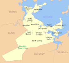 | |
|---|---|---|
| Schools | ||
| Colleges and universities | ||
| Landmarks | ||
| Media | ||
| MBTA stations | ||
| Islands | ||
| History | ||