Houaphanh Province
| Houaphanh ແຂວງ ຫົວພັນ | |
|---|---|
| Province | |
 | |
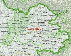 Map of Houaphan Province | |
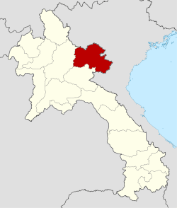 Location of Houaphanh Province in Laos | |
| Coordinates: 20°20′00″N 103°49′59″E / 20.3333°N 103.833°ECoordinates: 20°20′00″N 103°49′59″E / 20.3333°N 103.833°E | |
| Country |
|
| Capital | Xam Neua |
| Area | |
| • Total | 16,500 km2 (6,400 sq mi) |
| Population (2015 census) | |
| • Total | 289,393 |
| • Density | 18/km2 (45/sq mi) |
| Time zone | UTC+07 |
| ISO 3166 code | LA-HO |
Houaphanh province (Laotian: ແຂວງ ຫົວພັນ [kʰwɛ̌ːŋ hwǎː pʰán]) is a province of eastern Laos. As of 2015 it had a population of 289,393 people. Its capital lies at Sam Neua.
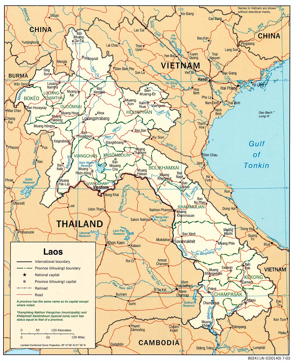
Houaphanh Province covers an area of 16,500 square kilometres (6,400 sq mi). The province is bordered by Vietnam to the north, east and southeast, Xiangkhouang Province to the south and southwest, and Luang Prabang Province to the west. The terrain is rugged, with dense mountainous forest forming much of the province, particularly on the western side. The main road running through the province is Route 6. The principal rivers are the Song Ma, which flows from and into Vietnam, passing the village of Ban Muang-Et, and the Nam Sam, which the towns of Sam Neua and Sam Tai lie on.
The province is the home to the Viengxay caves, an extensive network of caves used by the Pathet Lao, and the Hintang Archaeological Park, one of the most important pre-historic sites in northern Laos, dotted with standing megaliths. Houaphanh is one of the poorest areas of Laos, but has dramatic scenery and fine textile traditions.
History
The province was home of the Bồn Man Kingdom (Muang Phuan Kingdom) since the 14th century. Following a Vietnamese invasion in 1478 led by Vietnamese King Lê Thánh Tông, it became Trấn Ninh Territory of the Đại Việt Kingdom with the capital at Sam Chau (present-day Sam Neua).[1] The area was known as Hua Phan Tang Ha Tang Hok, "the fifth and the sixth province",[2] and listed by Auguste Pavie as "Hua Panh, Tang-Ha, Tang-Hoc."[3]
It remained a Vietnamese outpost territory until 1893 when ownership was switched by French colonial authorities back to Laos during the French Colonial period. Under the French spelling of the province was usually Hua Phan.[1][3]
The province is the home to the Viengxay caves, an extensive network of caves used by the Pathet Lao. Numerous caves in the province served as hideouts for important figures in the Laos in the 1950s and 1960s. Tham Than Souphanouvong Cave was the hideout of the revolutionary leader and later the President, Souphanouvong, who built a base there in 1964.[4] Revolutionary leader and later the President Kaysone Phomvihane hid out in Tham Than Kaysone Cave from 1964, and later President Khamtay Siphandone hid out at Tham Than Khamtay Cave from 1964 and he established a base there, with meeting rooms, reception rooms and a research room.[4]
Houphanh Province was noted for its "samana" ("reeducation") camps. The Lao Royal Family were believed to have been taken to one such camp near Sop Hao in 1977. Crown Prince Say Vong Savang allegedly died at the camp in May 1978, followed by his father King Savang Vatthana from starvation, 11 days later.[5]
Religious minorities often face persecution in the province, and at the end of 1999 numerous minorities were arrested.[6]
Geography
Houaphanh Province, one of the provinces of Laos,[7] covers an area of 16,500 square kilometres (6,400 sq mi).[4] The province is bordered by Vietnam to the north, east and southeast, Xiangkhouang Province to the south and southwest, and Luang Prabang Province to the west.[8] The terrain is rugged, with dense mountainous forest forming much of the province, particularly on the western side.[9] Notable settlements in the province include Sam Neua, Muong U, Houamuang, Chomsan, Muang Pan, Muang Hom, Muang Peu, Muang Xon, Ban Muang-Et, Ban Nampang, Muong Vene, Xamtai, Muang Na, and Poungthak.[10] The main road running through the province is Route 6. The principal rivers are the Song Ma, which flows from and into Vietnam, passing the village of Ban Muang-Et, and the Nam Sam, which the town of Sam Neua lies on.[11]
Protected areas

Areas of Houaphanh Province are within of the Nam Et-Phou Louey National Biodiversity Conservation Area (NBCA) and the Nam Xam National Biodiversity Conservation Area. There are also some Important Bird Areas (IBA).[12]
The Nam Neun IBA area of Nam Et is adjacent to the NBCA.[12] Nam Neun is 85,450 ha in size, and is situated at an altitude of 800–1,500 metres (2,600–4,900 ft) above sea level. The habitat is characterized as mixed deciduous forest, as well as dry evergreen forest, with stands of bamboo, and occasional conifers; cleared areas have been replaced by areas of secondary grassland. Key avifauna include great hornbill (Buceros bicornis) and Blyth's kingfisher (Alcedo hercules).[13]
The Phou Louey Massif IBA is within the Nam Et-Phou Louey NBCA and adjacent to the Nam Neun IBA.The Phou Louey IBA stretches beyond Houaphanh Province, into Luang Prabang Province. It is 60,070 ha in size, and is situated at an altitude of 700–1,800 metres (2,300–5,900 ft) above sea level. The habitat is characterized as mixed deciduous forest, semi-evergreen forest, lower montane evergreen forest, upper montane evergreen forest, and secondary grassland. Key avifauna include beautiful nuthatch (Sitta formosa), rufous-necked hornbill (Aceros nipalensis), Blyth's kingfisher (Alcedo hercules), and yellow-vented warbler (Phylloscopus cantator). There are four confirmed species of turtles and two confirmed species of ungulate.[12]
The 69,000 hectare Nam Xam IBA is within the 70,000 ha Nam Xam National Biodiversity Conservation Area (NBCA). The IBA's altitude varies between 300–1,800 metres (980–5,910 ft) above sea level. The topography is characterized by hills and low mountains. The habitat includes dry evergreen forest, Fokienia forest, mixed deciduous forest, as well as stunted, mossy upper montane forest. Notable avifauna includes beautiful nuthatch (Sitta formosa), brown hornbill (Anorrhinus tickelli), great hornbill (Buceros bicornis), red-collared woodpecker (Picus rabieri), and rufous-necked hornbill (Aceros nipalensis). [14]
Administrative divisions
The province is made up of the following districts:[4]
| Map | Code | Name | Lao |
|---|---|---|---|
 | |||
| 7-01 | Xamneua District | ເມືອງຊຳເໜືອ | |
| 7-02 | Xiengkhor District | ເມືອງຊຽງຄໍ້ | |
| 7-03 | Viengthong District | ເມືອງວຽງທອງ | |
| 7-04 | Viengxay District | ເມືອງວຽງໄຊ | |
| 7-05 | Huameuang District | ເມືອງຫົວເມືອງ | |
| 7-06 | Xamtay District | ເມືອງຊຳໃຕ້ | |
| 7-07 | Sop Bao District | ເມືອງສົບເບົາ | |
| 7-08 | Et District | ເມືອງແອດ |
Economy
Houaphanh Province is one of the poorest areas of Laos. In 1998, three quarters of the population were classified as poor, and in 2002 GDP per capita was $50–204, compared to the national average of $350.[15] Numerous socio-economic problems plague the province, with an infant mortality rate and access to safe water and medical facilities far worse than the national average.[15] Bamboo is important in rural parts of the province and used as a principal building material. Women play a key role in the collecting of bamboo shoots.[15] In Viengxay district there are two bamboo processing factories which produce items such as floormats, fences, chopsticks and toothpicks for the Vietnamese market.[15] Overall though, the bamboo industry is undeveloped, and many find it difficult to find profitable markets for their goods.[15]
Sam Neua, the provincial centre is the most important market centre for regional trade. Many villagers in the province come here to sell their goods, especially handicrafts and textiles which the people of the province are famed for. Saleu and Nasala villages in Xiengkhor District along Route 6 are noted for their skills at weaving and handicrafts.[4] Sam Tai is noted for its textiles.[5] Rice farming is widely practiced in the province, although agriculture employs less than livestock farming. Principal cash crops include corn, sesame, soybean, and medicinal plants such as man on ling, duk duea, and kalamong, paper mulberry, styrax, cardamon and cinnamon.[15] Up to 15% are involved in opium cultivation, and up to 10% involved in making handicrafts.[15] Attempts to control poppy cultivation have been made through the Narcotics Crop Control Project and the Houaphanh Project Agreement.[16][17] A tourism development plan has been created for the province, capitalizing on the caves as tourist attractions, providing information and services at the sites.[18]
Asian Development Bank has also launched a project in 2006 specifically covering 31 villages of Xamneua and Xamtai districts of the province to wean people away from shifting cultivation practices and also to eliminate opium addiction; as of 2006, opium was still grown in the province in an area of about 30 ha. The project covers programs to increase income, conserve forest resources, opium eradication and experimenting with pilot projects to enhance livelihood sources.[19]
Demography
The population of the province, as of March 2005, is 280,898. The capital of the province is Xam Neua.[20]
Landmarks
Viengxay is known as a "Hidden Cave City", the heart of the Pathet Lao Liberation Movement between 1964–75 where 20,000 people lived in the caves with all facilities such as offices, hospital, temples, markets, school, and entertainment centre. Historical attractions here are: Kaysone Phomvihane's House where in the President Kaysone's garden people narrate the history of how Viengxay became the center for liberation and suffered air attacks in the beginning; the Kaysone Phomvihane's Cave Office the largest cave here where gifts a statue of Lenin and collection of books could be seen; Politburo Meeting Room in the cave the leaders of freedom movement deliberated on policies and important decisions; Nouhak Phoumsavan's House (Pathet Lao's founding father); Nouhak Phoumsavan's Cave, Prince Souphanouvong's (who was known as "Red Prince") House & Garden; a Stupa erected during the war time to bury Souphanouvong's son, Ariya Thammasin to avoid detection during the war; Prince Souphanouvong's Cave used as a protection bunker during bombing by US forces known as "Ravens"; Cave of Phoumi Vongvichid's who established a schooling curriculum in the cave; Cave of Sithone Kommadane, a valiant fighter during early years of war; a small Hospital Cave; House of General Khamtay Siphandone, supreme military commander who motivated people to take to arms and Khamtay Siphandone's Cave where he established and operated the communication system with his forces; Cave Barracks of ex soldiers; Artillery Cave where heavy anti-aircraft batteries were operated; and the Xanglot Cave where weddings and traditional festivals were held during the war.[21]
Wat Pho Xai or Wat Pho Xaysanalam is located on the outskirts of Sam Neua. Hintang Archaeological Park, a UNESCO World Heritage Site, is one of the most important pre-historic sites in northern Laos, dotted with about 2,000 years old menhirs (standing stones) or megaliths, which were unearthed in 1931. Locals refer to it as Sao Hin Tang, meaning "Standing Stone Pillars". It is also known as the Stonehenge of Laos, with many 2 metre high stones. Apart from these finds, funerary burial sites with artifacts of ancient trinkets, standing rock slabs and stone disks were also found. These archaeological finds are older than the Plain of Jars and are seen along a 12-km mountain ridge in the southern part of the province.[22][21] Local animists believe that the stone discs at the site once sat atop the megaliths and fed Jahn Han, the sky spirit.[22] 11 kilometres (6.8 mi) from Sam Neua is the Ban Tham Buddha Cave.[5] Tat Saloei (Phonesai) Waterfall lies off the road to Nam Noen, about 35 kilometres (22 mi) south of Sam Neua.[5]
The Nameuang Hot Springs is another landmark in the province located amidst the valley of paddy fields on the way to Xamneua, where there is also a Houaiyad waterfall close. The springs are the source of a small river. In the Houaiyad Village, crashed aircraft parts and cans of war relics are recycled into belts.[21]
Gallery
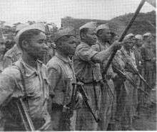 Pathet Lao at Xam Neua in 1953.
 Market woman in Xam Neua
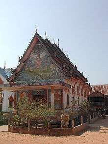 Wat Pho Xai in Xam Neua
References
- 1 2 Auzias & Labourdette 2012, p. 265.
- ↑ The Thai peoples - Volume 1 - Page 91 Erik Seidenfaden - 1967 They are Buddhists but also animists and much given to feast the spirits of their ancestors.1 Southeast of Muang Thaeng, and east of the Annamite cordillera, lies the plateau of and east of the Annamite cordillera, lies the plateau of Hua Phan, formerly known as Hua Phan Tang Ha Tang Hok i.e. the five and the sixth province, some translate this as the five and the sixth county of one thousand inhabitants each."
- 1 2 Mission Pavie, Indo-Chine, 1879-1895: Etudes diverses - Volume 3 - Page 142 1900 "Ces territoires, dont le nom serait: Hua Panh, Tang-Ha, Tang-Hoc. comprendraient, en plus des six grands cantons énumérés ailleurs,"
- 1 2 3 4 5 "Huaphanh Province". Lao Tourism Organization. Retrieved 1 December 2012.
- 1 2 3 4 Burke & Vaisutis 2007, p. 185.
- ↑ Larkin 2001, p. 202.
- ↑ "Home". Regions. Official website of Laos Tourism. Retrieved 7 January 2013.
- ↑ Maps (Map). Google Maps.
- ↑ APANews. Asia-Pacific Agroforestry Network. 1992. pp. 112–3. Retrieved 6 December 2012.
- ↑ "Base Map:Lao People's Democratic Republic (LPDR)". UNOSAT. Retrieved 4 December 2012.
- ↑ "Laos". Ecoi.net. Retrieved 6 December 2012.
- 1 2 3 "Important Bird Areas factsheet: Phou Louey". BirdLife International. Retrieved 6 December 2012.
|first1=missing|last1=in Authors list (help) - ↑ "Nam Et NPA" (PDF). birdlifeindochina.org. BirdLife International. Retrieved 6 December 2012.
- ↑ "Important Bird Areas factsheet: Nam Xam". BirdLife International. 2012. Retrieved 6 December 2012.
- 1 2 3 4 5 6 7 "Houaphanh Bamboo Value Chain Analysis" (PDF). Netherlands Development Organization. Retrieved 6 December 2012.
- ↑ United States. Congress. House. Committee on Appropriations. Subcommittee on Foreign Operations, Export Financing, and Related Programs (2002). Foreign Operations, Export Financing, and Related Programs Appropriations for 2003: Hearings Before a Subcommittee of the Committee on Appropriations, House of Representatives, One Hundred Seventh Congress, Second Session. U.S. Government Printing Office. p. 860. Retrieved 6 December 2012.
- ↑ United States. Congress. House. Committee on Foreign Affairs (1991). Narcotics control efforts in Southeast Asia: business as usual : report of a staff study mission to CINCPAC, the Philippines, Singapore, Thailand, Laos, Hong Kong, and the People's Republic of China, November 2–26, 1990 to the Committee on Foreign Affairs, U.S. House of Representatives. U.S. G.P.O. p. 20. Retrieved 6 December 2012.
- ↑ Hitchcock 2009, p. 175.
- ↑ "Description: Alternative Livelihood for Upland Ethnic Groups in Houaphanh Province (Financed by the Japan Fund for Poverty Reduction)". Asian Development Bank. Retrieved 12 December 2012.
- ↑ "Provinces of Laos". Statoids.com. Retrieved 1 November 2012.
- 1 2 3 "Houpanh Province: Birth Place of Lao PDR" (pdf). STDP Laos. Retrieved 12 December 2012.
- 1 2 Burke & Vaisutis 2007, p. 186.
Bibliography
- Auzias, Dominique; Labourdette, Jean-Paul (28 March 2012). Laos 2012–2013 (in French). Petit Futé. ISBN 978-2-7469-5375-8.
- Burke, Andrew; Vaisutis, Justine (1 August 2007). Laos 6th Edition. Lonely Planet. ISBN 978-1-74104-568-0.
- Hitchcock, Michael (2009). Tourism in Southeast Asia: Challenges and New Directions. NIAS Press. ISBN 978-87-7694-034-8.
- Larkin, Barbara (1 July 2001). International Religious Freedom (2000): Report to Congress by the Department of State. DIANE Publishing. ISBN 978-0-7567-1229-7.
 |
Sơn La Province, |
| ||
| Luang Prabang Province | |
Thanh Hóa Province, | ||
| ||||
| | ||||
| Xiangkhoang Province | Nghệ An Province, |
| Attapu | |
|---|---|
| Bokeo | |
| Bolikhamsai | |
| Champassack | |
| Houaphanh | |
| Khammouane | |
| Louang Namtha | |
| Luang Prabang | |
| Oudomxay | |
| Phongsaly | |
| Salavan | |
| Savannakhet | |
| Sekong | |
| Vientiane |
|
| Vientiane (Viengchan) |
|
| Xaignabouli | |
| Xiangkhouang | |