Horseshoe 2 Fire
| Horseshoe 2 Fire | |
|---|---|
|
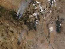
Photograph of the Horseshoe 2 Fire from space | |
| Location | Arizona |
| Statistics | |
| Cost | $50.2 million[1] |
| Date(s) | May 8, 2011-June 25, 2011 |
| Burned area | 222,954 acres (348.366 sq mi; 90,226 ha) (as of 26 June 2011)[1] |
| Cause | human activities |
| Land use | forest, wildland/urban interface |
| Buildings destroyed | 23 |


The Horseshoe 2 Fire was a 2011 wildfire located along the southeastern flank of the Chiricahua Mountains in southeastern Arizona. It began in Horseshoe Canyon on the Douglas Ranger District of the Coronado National Forest on May 8, 2011, at approximately 11:00 a.m.[2] The fire was started by human activities,[2][3] and burned over 9,000 acres (14 sq mi; 3,600 ha) in its first day.[4] By June 1, 2011, the fire had burned an area of over 80,500 acres (125.8 sq mi; 32,600 ha) of grasses, shrubs, and trees along the mountain slopes.[5] By June 8, it had grown to 106,661 acres (166.658 sq mi; 43,164 ha).[6] By June 17, the fire was 65% contained[4] and had become the fifth-largest wildfire in Arizona history.[7] 100% containment was achieved on June 25 after a total area of 222,954 acres (348.366 sq mi; 90,226 ha) had burned.[1]
Post-fire conditions
Regions of the Chiricahua Mountains close to the small commonwealth of Portal are experiencing a slow ecological recovery after the Horseshoe 2 fire burned more than 200,000 acres in 2011.[8] Both the biggest draws to area are intact, but a lot has changed after past year 's Horseshoe 2 Fire swept across those rugged mountains .[9] Additionally, because of a mix of flood harm after the Horseshoe 2 fire of 2011 and infrequent maintenance, trail conditions have changed quickly and particularly during monsoon season it is necessary to be careful.[10]
See also
- 2011 Wallow Fire
References
- 1 2 3 Northern Rockies Incident Management Team (26 June 2011). "Horseshoe 2 Fire Update for 6-26, 8 AM". InciWeb: Incident Information System. Archived from the original on 26 June 2011.
- 1 2 "Horseshoe 2 Fire, Arizona". NASA.
- ↑ Jordan, Derek (14 May 2011) "Horseshoe 2 Fire is hurting several small businesses" The Sierra Vista Herald; archived here by WebCite
- 1 2 Great Basin 2 Incident Management Team (17 June 2011). "Horseshoe Two: Horseshoe 2 Update for 6-17, 11 AM". InciWeb: Incident Information System. Archived from the original on 17 June 2011.
- ↑ "Horseshoe Two Fire Sized at 80,500 Acres, Remains 75 Percent Contained" Arizona Emergency Information Network (AzEIN) Bulletin, 1 June 2011; archived here by WebCite
- ↑ Horseshoe 2 Fire Update, June 8, 2011 9:00 AM, InciWeb.org.
- ↑ "Massive White Mountains fire marks start of frightening season", Pete Aleshire. Payson Roundup. June 10, 2011. Accessed June 11, 2011
- ↑ https://www.azpm.org/p/home-featured/2013/5/8/24253-horseshoe-2-fire-two-years-later/
- ↑ http://archive.azcentral.com/travel/articles/20120921tempered-beauty-chiricahua-national-monument.html
- ↑ http://www.chiricahuatrails.com/
External links
- As Arizona Fire Rages, So Does Rumor on Its Origin - New York Times
- Horseshoe Two - InciWeb Incident Information System
Coordinates: 31°49′12″N 109°12′40″W / 31.82°N 109.211°W