Horfield
| Horfield | |
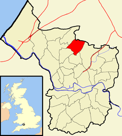 Boundaries of the city council ward |
|
| Population | 12,826 (2011.Ward)[1] |
|---|---|
| OS grid reference | ST597769 |
| Unitary authority | Bristol |
| Ceremonial county | Bristol |
| Region | South West |
| Country | England |
| Sovereign state | United Kingdom |
| Post town | BRISTOL |
| Postcode district | BS7 |
| Dialling code | 0117 |
| Police | Avon and Somerset |
| Fire | Avon |
| Ambulance | South Western |
| EU Parliament | South West England |
| UK Parliament | Bristol North West |
Coordinates: 51°29′24″N 2°34′50″W / 51.4900°N 2.5805°W

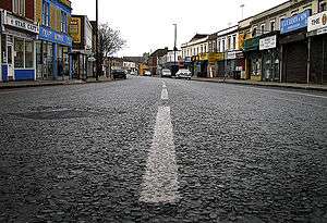
Horfield is a suburb of the city of Bristol, in southwest England. It lies on Bristol's northern edge, its border with Filton marking part of the boundary between Bristol and South Gloucestershire. Bishopston lies directly to the south. Monks Park and Golden Hill are to the west. Lockleaze and Ashley Down are on the eastern fringe. The Gloucester Road (A38) runs north/south through the suburb.
Horfield is also the name of a ward for Bristol City Council. The ward includes Monks Park and Southmead Hospital, but does not include the southern part of Horfield, including Horfield Common and Horfield Prison, which is in Bishopston ward.
History
The name 'Horfield' is Anglo-Saxon in origin, meaning 'Filthy open land' (Old English 'horu' and 'feld').[2]
Horfield was a parish in the hundred of Berkeley in Gloucestershire, which included Bishopston, Golden Hill, Lockleaze and part of Ashley Down.[3]
Historically, the area had a reputation as a lawless place because Horfield Wood was the haunt of thieves and vagrants. The area remained rural until the early 19th century.
Following the 1831 Bristol Riots, during which the local gaol burnt down, Horfield Prison was completed in 1847. A permanent military presence was established in the city with the completion of Horfield Barracks also in 1847.[4]
Horfield was mostly developed from the mid 19th century onwards. In 1859, Bishopston became a separate parish. The remainder of Horfield became a civil parish in 1866, when civil parishes were introduced. In 1894 Horfield Urban District was formed, but in 1904 it was absorbed into Bristol.[5]
Amenities
Horfield is home to the Memorial Stadium: a sports stadium built in 1921 for Bristol Rugby Club in memory of the rugby union players of the city who died in World War I, and rededicated to also commemorate the dead of World War II. In 1996, the ground also became home to Bristol Rovers Football Club who now own it.
Near the Stadium is The Wellington, CAMRA Bristol & District joint winner of Pub of the Year for 2005. The 2006 Pub of the Year is also in Horfield, The Inn on the Green (on the Gloucester Road)
Horfield has a leisure centre that was updated to have a 25-metre swimming pool in 2005.
Transport
Horfield is served by bus services on Gloucester Road (First routes 24, 25, 70, 71, 72, 73, 75, 76, 78 and 79 and Wessex Connect routes 11,12, 15 and 19), and Muller Road (Wessex Connect routes 506 and 507).
Between 1927 and 1964, the northeast part of the district was served by Horfield railway station.
Notable residents
Famous sons of Horfield include Hollywood actor Cary Grant, who was born at 15 Hughenden Road, in 1904, and composer Ray Steadman-Allen was born at 64 Muller Road, in 1922.
Politics
The parish of Horfield includes Horfield ward to the north, part of the Bristol North West parliamentary constituency, of which the incumbent Member of Parliament (for the Bristol West constituency) is the Conservative, Charlotte Leslie. On Bristol City Council, Horfield ward sends two councillors. Currently, these are Cllr Olly Mead (Labour) and Cllr Claire Hiscott (Conservative).
The southern part of the parish is in Bishopston ward, in Bristol West parliamentary constituency. The sitting Member of Parliament is Thangam Debbonaire, Labour. The current councillors are Cllr David Willingham (Liberal Democrat) and Cllr Daniella Radice (Green)
Churches
There are a number of interesting churches in Horfield.
| Wikimedia Commons has media related to Horfield Parish Church. |
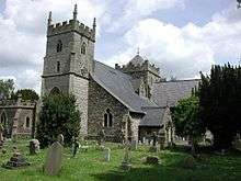
Church of the Holy Trinity with St Edmund – the parish church was possibly founded as early as 603 but the earliest remnant is an old pillar and the circular churchyard. The tower is late 15th century or early 16th century with the nave and aisles added to by William Butterfield in 1847. The central tower was erected in 1893 by local firm Crisp & Oately and the transepts later in 1913 and 1929. It is a grade II* listed building.[6]
St. Edmunds Church – erected in the lancet style in 1860 by ST Welch erected as a school and then given a tower and side asiles in 1930 by Hartland Thomas. A building with a roof (similar to Horfield Parish), Anglo catholic interior, and a high church tradition. The church closed in 1979 and was a printers but was demolished in 2006 – the local planning authority did not request obligatory photos.
Horfield Barracks chapel – erected 1859 (not 1847 as in Buildings of England). A fine lancet styled chapel with some good handling of dressings and very good bellcote. Closed in the 1920s and has been converted to offices. It is grade II listed.[7]
Methodist Chapel – 1899 by La Trobe – very good essay in late Victorian Arts and Crafts Gothic with a fine wooden interior.
The former Salvation Army chapel – in Ashley Down Road.
Horfield Baptist Chapel – a twin towered perpendicular chapel by Milverton Drake with an organ by Hele.
The Roman Catholic Chapel of St Maximillian Kolbe with St Edith Stein and the Holocaust Martyrs – in Alfoxton Road.
Quaker meeting house of 1906 – domestic red brick.
Whitefield Tabernacle Muller Road – Contains the 18th century pulpit removed from Penn Street Tabernacle when that was demolished to make way for the city centre. It also contains the superb 1815 wooden organ case.
References
- ↑ "Horfield" (PDF). 2011 Census Ward Information Sheet. Retrieved 26 February 2015.
- ↑ Cameron English Nottingham University
- ↑ Horfield by Brenda Hardingham
- ↑ "Footsteps into the past - Horfield Barracks". Bristol Post. 16 September 2014. Retrieved 9 November 2014.
- ↑ Vision of Britain website
- ↑ "Church of the Holy Trinity with St Edmund". Images of England. Retrieved 19 February 2007.
- ↑ "Old Chapel Buildings". Images of England. Retrieved 19 February 2007.
External links
| Wikimedia Commons has media related to Horfield (Bristol ward). |