Hopkins, Michigan
| Hopkins, Michigan | |
|---|---|
| Village | |
 Location of Hopkins, Michigan | |
| Coordinates: 42°37′28″N 85°45′44″W / 42.62444°N 85.76222°W | |
| Country | United States |
| State | Michigan |
| County | Allegan |
| Area[1] | |
| • Total | 0.48 sq mi (1.24 km2) |
| • Land | 0.48 sq mi (1.24 km2) |
| • Water | 0 sq mi (0 km2) |
| Elevation | 709 ft (216 m) |
| Population (2010)[2] | |
| • Total | 610 |
| • Estimate (2012[3]) | 608 |
| • Density | 1,270.8/sq mi (490.7/km2) |
| Time zone | Eastern (EST) (UTC-5) |
| • Summer (DST) | EDT (UTC-4) |
| ZIP code | 49328 |
| Area code(s) | 269 |
| FIPS code | 26-39180[4] |
| GNIS feature ID | 0628573[5] |
| Website | website |
Hopkins, formerly Hopkins Station, is a village within Hopkins Township in Allegan County in the U.S. state of Michigan. The population was 610 at the 2010 census.
History
In 1854, John Hoffmaster settled here. On May 20, 1854, the Hopkins post office was opened with Erastus Congdon as its first postmaster. The Hopkins Station post office opened on March 28, 1870 with postmaster Henry F. Guyot. Hopkins Station was the name of the railroad depot opened in 1874. Hoffmaster became the first depot master and platted the village. On May 31, 1904, the Hopkins post office was closed. On June 6, 1906, the Hopkins Station post office was shorted to just Hopkins.[6]
Hopkins was incorporated as a village in 1920. On January 31, 1929, Claude B. Hoffmaster became postmaster.[6]
Government
As a village, Hopkins is provided assessing, counties and school districts tax collecting and elections administration for county, state and national by Hopkins Township. The village is responsible for local regulatory ordinances and to providing fire and police protection, public works, utilities and other local services. Cement City is a home rule village. Per its charter the village charter provides for a board of trustees of six. Trustees are serve two year elected terms. One year term elected official are the president, clerk, treasurer and assessor.[7]
Geography
According to the United States Census Bureau, the village has a total area of 0.48 square miles (1.24 km2), all land.[1]
Demographics
| Historical population | |||
|---|---|---|---|
| Census | Pop. | %± | |
| 1930 | 384 | — | |
| 1940 | 455 | 18.5% | |
| 1950 | 531 | 16.7% | |
| 1960 | 556 | 4.7% | |
| 1970 | 566 | 1.8% | |
| 1980 | 536 | −5.3% | |
| 1990 | 546 | 1.9% | |
| 2000 | 592 | 8.4% | |
| 2010 | 610 | 3.0% | |
| Est. 2015 | 608 | [8] | −0.3% |
2010 census
As of the census[2] of 2010, there were 610 people, 227 households, and 166 families residing in the village. The population density was 1,270.8 inhabitants per square mile (490.7/km2). There were 247 housing units at an average density of 514.6 per square mile (198.7/km2). The racial makeup of the village was 93.8% White, 1.3% Native American, 0.2% Asian, 1.6% from other races, and 3.1% from two or more races. Hispanic or Latino of any race were 3.9% of the population.
There were 227 households of which 42.3% had children under the age of 18 living with them, 52.4% were married couples living together, 16.7% had a female householder with no husband present, 4.0% had a male householder with no wife present, and 26.9% were non-families. 23.8% of all households were made up of individuals and 8.4% had someone living alone who was 65 years of age or older. The average household size was 2.69 and the average family size was 3.11.
The median age in the village was 32.7 years. 30.2% of residents were under the age of 18; 8.7% were between the ages of 18 and 24; 28.5% were from 25 to 44; 23.4% were from 45 to 64; and 9.2% were 65 years of age or older. The gender makeup of the village was 50.5% male and 49.5% female.
2000 census
As of the census[4] of 2000, there were 592 people, 219 households, and 162 families residing in the village. The population density was 1,137.1 per square mile (439.6/km²). There were 229 housing units at an average density of 439.9 per square mile (170.0/km²). The racial makeup of the village was 94.09% White, 0.51% African American, 1.86% Native American, 1.18% Asian, 0.17% from other races, and 2.20% from two or more races. Hispanic or Latino of any race were 1.01% of the population.
There were 219 households out of which 39.3% had children under the age of 18 living with them, 56.2% were married couples living together, 14.2% had a female householder with no husband present, and 26.0% were non-families. 23.3% of all households were made up of individuals and 9.1% had someone living alone who was 65 years of age or older. The average household size was 2.70 and the average family size was 3.19.
In the village the population was spread out with 29.9% under the age of 18, 10.1% from 18 to 24, 28.5% from 25 to 44, 19.4% from 45 to 64, and 12.0% who were 65 years of age or older. The median age was 34 years. For every 100 females there were 100.7 males. For every 100 females age 18 and over, there were 100.5 males.
The median income for a household in the village was $38,462, and the median income for a family was $39,583. Males had a median income of $31,500 versus $22,500 for females. The per capita income for the village was $16,667. About 8.5% of families and 8.9% of the population were below the poverty line, including 5.4% of those under age 18 and 8.5% of those age 65 or over.
Climate
This climatic region is typified by large seasonal temperature differences, with warm to hot (and often humid) summers and cold (sometimes severely cold) winters. According to the Köppen Climate Classification system, Hopkins has a humid continental climate, abbreviated "Dfb" on climate maps.[10]
References
- 1 2 "US Gazetteer files 2010". United States Census Bureau. Retrieved 2012-11-25.
- 1 2 "American FactFinder". United States Census Bureau. Retrieved 2012-11-25.
- ↑ "Population Estimates". United States Census Bureau. Retrieved 2013-06-03.
- 1 2 "American FactFinder". United States Census Bureau. Retrieved 2008-01-31.
- ↑ U.S. Geological Survey Geographic Names Information System: Hopkins, Michigan
- 1 2 Romig, Walter (1973). Michigan Place Names. 081431838X: Wayne State University Press. p. 272. Retrieved February 16, 2016.
- ↑ (January 2011). Pages 1,5. Municipal Report: Organization of City and Village Government in Michigan. Updated. Michigan Municipal League. Accessed on February 15, 2016.
- ↑ "Annual Estimates of the Resident Population for Incorporated Places: April 1, 2010 to July 1, 2015". Retrieved July 2, 2016.
- ↑ "Census of Population and Housing". Census.gov. Retrieved June 4, 2015.
- ↑ Climate Summary for Hopkins, Michigan
Municipalities and communities of Allegan County, Michigan, United States | ||
|---|---|---|
| City | 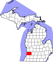 | |
| Villages | ||
| Charter township | ||
| General law townships | ||
| Unincorporated communities | ||
| Footnotes | ‡This populated place also has portions in an adjacent county or counties | |
Coordinates: 42°37′25″N 85°45′37″W / 42.62361°N 85.76028°W