Hopewell Junction, New York
| Hopewell Junction, New York | |
|---|---|
| Census-designated place | |
|
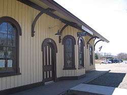
The former rail depot that served the junction of ND&C, NY&NE, and DCR for which the community was named | |
 Location of Hopewell Junction, New York | |
| Coordinates: 41°35′2″N 73°48′31″W / 41.58389°N 73.80861°WCoordinates: 41°35′2″N 73°48′31″W / 41.58389°N 73.80861°W | |
| Country | United States |
| State | New York |
| County | Dutchess |
| Town | East Fishkill |
| Area | |
| • Total | 0.5 sq mi (1.2 km2) |
| • Land | 0.5 sq mi (1.2 km2) |
| • Water | 0.0 sq mi (0.0 km2) |
| Elevation | 246 ft (75 m) |
| Population (2010) | |
| • Total | 376 |
| • Density | 794/sq mi (306.5/km2) |
| Time zone | Eastern (EST) (UTC-5) |
| • Summer (DST) | EDT (UTC-4) |
| ZIP code | 12533 |
| Area code(s) | 845 Exchanges: 221,226,227,592 |
| FIPS code | 36-35573 |
| GNIS feature ID | 0953194 |
Hopewell Junction is a hamlet and census-designated place (CDP) in Dutchess County, New York, United States. The population was 376 at the 2010 census.[1] It is part of the Poughkeepsie–Newburgh–Middletown, NY Metropolitan Statistical Area as well as the larger New York–Newark–Bridgeport, NY-NJ-CT-PA Combined Statistical Area.
Hopewell Junction is located within the town of East Fishkill. It was originally a railroad junction where the Newburgh, Dutchess and Connecticut Railroad met the New York and New England Railroad and Dutchess County Railroad. All three became part of the New York, New Haven and Hartford Railroad system, and the ND&C to the southwest and the NY&NE are now owned by the Housatonic Railroad and used by Metro-North for equipment moves between its Hudson Line and Harlem Line. The railroad that goes through Hopewell is no longer in use; the closest one is Metro-North's Hudson Line.
It was ranked #31 on Money magazine's "Most Desirable Places to Live" for 2005.
Geography
Hopewell Junction is located near the center of the town of East Fishkill at 41°35′N 73°48′W / 41.583°N 73.800°W (41.584, -73.806),[2] to the north of Fishkill Creek.
According to the United States Census Bureau, the CDP has a total area of 0.46 square miles (1.2 km2), all land,[1] a significant reduction from the 2000 Census delineation, when the CDP had an area of 2.8 square miles (7.3 km2).
Demographics

As of the census[3] of 2000, there were 2,610 people, 894 households, and 688 families residing in the CDP. The population density was 923.4 per square mile (356.1/km²). There were 914 housing units at an average density of 323.4/sq mi (124.7/km²). The racial makeup of the CDP was 92.26% White, 1.80% African American, 0.27% Native American, 3.91% Asian, 0.42% from other races, and 1.34% from two or more races. Hispanic or Latino of any race were 3.98% of the population.
There were 894 households out of which 42.4% had children under the age of 18 living with them, 65.9% were married couples living together, 8.1% had a female householder with no husband present, and 23.0% were non-families. 19.6% of all households were made up of individuals and 5.8% had someone living alone who was 65 years of age or older. The average household size was 2.91 and the average family size was 3.37.
In the CDP the population was spread out with 20.9% under the age of 18, 6.5% from 18 to 24, 29.1% from 25 to 44, 35.5% from 45 to 64, and 10.0% who were 65 years of age or older. For every 100 females there were 96.7 males. For every 100 females age 18 and over, there were 94.9 males.
The median income for a household in the CDP was $106,042, and the median income for a family was $135,625.[4] Males had a median income of $49,750 versus $33,092 for females. The per capita income for the CDP was $26,844. About 2.3% of families and 4.3% of the population were below the poverty line, including 5.3% of those under age 18.
Transportation
Hopewell Junction is served by Dutchess LOOP's route F.[5][6]
Notable residents
- Henry Morgenthau, Jr., Secretary of the Treasury under Franklin D. Roosevelt; started Fishkill Farms orchard in Hopewell Junction
- Joe Panik, second baseman for the San Francisco Giants[7]
- Jason Scott, technology historian and archivist
References
- 1 2 "Geographic Identifiers: 2010 Demographic Profile Data (G001): Hopewell Junction CDP, New York". U.S. Census Bureau, American Factfinder. Retrieved November 19, 2015.
- ↑ "US Gazetteer files: 2010, 2000, and 1990". United States Census Bureau. 2011-02-12. Retrieved 2011-04-23.
- ↑ "American FactFinder". United States Census Bureau. Retrieved 2008-01-31.
- ↑ http://factfinder2.census.gov/faces/tableservices/jsf/pages/productview.xhtml?pid=ACS_11_5YR_DP03
- ↑ http://www.dutchessny.gov/loopbus/
- ↑ http://www.co.dutchess.ny.us/CountyGov/Departments/MassTransit/looprtfmonfri.pdf
- ↑ McMann, Sean T. (4 August 2014). "Joe Panik: Q&A with Giants' infielder". Gannett. Poughkeepsie Journal. Retrieved 23 August 2014.
External links
| Wikimedia Commons has media related to Hopewell Junction, New York. |
Municipalities and communities of Dutchess County, New York, United States | ||
|---|---|---|
| Cities | 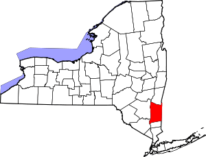 | |
| Towns | ||
| Villages | ||
| CDPs | ||
| Other hamlets | ||
| Footnotes | ‡This populated place also has portions in an adjacent county or counties | |