Hooksett, New Hampshire
| Hooksett, New Hampshire | ||
|---|---|---|
| Town | ||
|
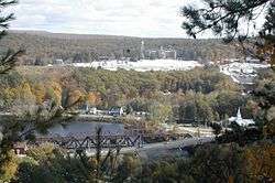
Hooksett Village from the Pinnacle | ||
| ||
 Location in Merrimack County and the state of New Hampshire | ||
| Coordinates: 43°05′48″N 71°27′54″W / 43.09667°N 71.46500°WCoordinates: 43°05′48″N 71°27′54″W / 43.09667°N 71.46500°W | ||
| Country | United States | |
| State | New Hampshire | |
| County | Merrimack | |
| Incorporated | 1822 | |
| Government | ||
| • Town Council |
Timothy Tsantoulis Robert Duhaime James A. Levesque Marc Miville Donald Winterton John Giotas David Ross Adam Jennings James Sullivan | |
| • Town Administrator | Dean E. Shankle, Jr. | |
| Area | ||
| • Total | 37.5 sq mi (97.1 km2) | |
| • Land | 36.4 sq mi (94.4 km2) | |
| • Water | 1.0 sq mi (2.7 km2) 2.71% | |
| Elevation | 213 ft (65 m) | |
| Population (2010) | ||
| • Total | 13,451 | |
| • Density | 369/sq mi (142.4/km2) | |
| Time zone | Eastern (UTC-5) | |
| • Summer (DST) | Eastern (UTC-4) | |
| ZIP code | 03106 | |
| Area code(s) | 603 | |
| FIPS code | 33-37300 | |
| GNIS feature ID | 0873629 | |
| Website |
www | |

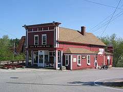
Hooksett is a town in Merrimack County, New Hampshire, United States. The population was 13,451 at the 2010 census.[1] The town is located between Manchester, the state's largest city, and Concord, the state capital. A prominent landmark is Robie's Country Store, a National Historic Landmark and a frequent stop for presidential candidates during the New Hampshire primary.[2]
The central village in town, where 4,147 people resided at the 2010 census,[1] is defined as the Hooksett census-designated place and is located at a bridge crossing of the Merrimack River. The town also contains the census-designated place of South Hooksett.
History
Hooksett was incorporated in 1822. First known as Chester Woods and Rowe's Corner, this town was called Hooksett for nearly fifty years before being incorporated. The name may have come from a hook-shaped island in the Merrimack or from early fishermen, who called the area Hookline Falls. Rocky ledges flank the Merrimack River, and there were several cross-river ferries located here, as well as lumber mills and a brick-making establishment powered by the falls. In 1794, the lottery-funded Hooksett Canal became part of the transportation facilities of the Amoskeag cotton mills in Manchester. The first census, taken in 1830, reported 880 residents.
Geography
Hooksett is situated on the Merrimack River in south-central New Hampshire. Interstate 93 connects Hooksett to the White Mountains and Boston. Hooksett lies fully within the Merrimack River watershed.[3]
According to the United States Census Bureau, the town has a total area of 37.5 square miles (97.1 km2), of which 36.4 square miles (94.4 km2) is land and 1.0 square mile (2.7 km2) is water, comprising 2.76% of the town.[4] Hooksett village, a census-designated place in the northern part of town, has a total area of 5.2 square miles (13.4 km2), of which 4.8 square miles (12.4 km2) is land and 0.39 square miles (1.0 km2), or 7.43%, is water.[5]
The highest point in Hooksett is Quimby Mountain, at 902 feet (275 m) above sea level, near the town's western border. On the town's eastern border, a ridge ascending towards Hall Mountain in neighboring Candia reaches 900 feet (270 m) above sea level.
Demographics
| Historical population | |||
|---|---|---|---|
| Census | Pop. | %± | |
| 1830 | 880 | — | |
| 1840 | 1,175 | 33.5% | |
| 1850 | 1,503 | 27.9% | |
| 1860 | 1,257 | −16.4% | |
| 1870 | 1,330 | 5.8% | |
| 1880 | 1,766 | 32.8% | |
| 1890 | 1,893 | 7.2% | |
| 1900 | 1,665 | −12.0% | |
| 1910 | 1,528 | −8.2% | |
| 1920 | 1,828 | 19.6% | |
| 1930 | 2,132 | 16.6% | |
| 1940 | 2,273 | 6.6% | |
| 1950 | 2,792 | 22.8% | |
| 1960 | 3,713 | 33.0% | |
| 1970 | 5,564 | 49.9% | |
| 1980 | 7,303 | 31.3% | |
| 1990 | 8,767 | 20.0% | |
| 2000 | 11,721 | 33.7% | |
| 2010 | 13,451 | 14.8% | |
| Est. 2015 | 14,098 | [6] | 4.8% |
As of the census of 2010, there were 13,451 people, 4,926 households, and 3,533 families residing in the town. The population density was 369 people per square mile (142.4/km²). There were 5,184 housing units at an average density of 54.9 units/km² (142.4 units/sq mi). The racial makeup of the town was 94.6% White, 1.0% African American, 0.2% Native American, 2.0% Asian, 0.1% Pacific Islander, 0.7% some other race, and 1.5% from two or more races. 2.1% of the population were Hispanic or Latino of any race.[8]
There were 4,926 households, out of which 34.2% had children under the age of 18 living with them, 59.0% were headed by married couples living together, 8.8% had a female householder with no husband present, and 28.3% were non-families. 20.4% of all households were made up of individuals, and 7.6% were someone living alone who was 65 years of age or older. The average household size was 2.59, and the average family size was 3.01.[8]
In the town the population was spread out with 22.4% under the age of 18, 10.9% from 18 to 24, 25.1% from 25 to 44, 30.0% from 45 to 64, and 11.6% who were 65 years of age or older. The median age was 39.8 years. For every 100 females there were 93.7 males. For every 100 females age 18 and over, there were 91.8 males.[8]
For the period 2009 through 2013, the estimated median annual income for a household in the town was $81,792, and the median income for a family was $96,469. Male full-time workers had a median income of $57,228 versus $45,116 for females. The per capita income for the town was $34,355.[9]
Hooksett village
The Hooksett census-designated place (CDP) comprises the village of Hooksett, located on both sides of the Merrimack River in the northern part of the town. The CDP extends north to the Bow and Allenstown town lines and south to a point south of Meadowcrest Road on the west side of the Merrimack and to Peters Brook, just south of Hunt Street, on the east side of the Merrimack.[10]
As of the census of 2010, there were 4,147 people, 1,819 households, and 1,166 families residing in the CDP. The population density was 882.3 people per square mile (334.6/km²). There were 1,945 housing units at an average density of 156.9 persons/km² (413.8 persons/sq mi). The racial makeup of the CDP was 93.9% White, 1.6% African American, 0.1% Native American, 1.8% Asian, 0.1% Pacific Islander, 0.8% some other race, and 1.7% from two or more races. 2.3% of the population were Hispanic or Latino of any race.[11]
There were 1,819 households, out of which 27.3% had children under the age of 18 living with them, 49.1% were headed by married couples living together, 10.8% had a female householder with no husband present, and 35.9% were non-families. 26.7% of all households were individuals, and 8.4% were someone living alone who was 65 years of age or older. The average household size was 2.28, and the average family size was 2.75.[11]
In the CDP the population was spread out with 19.7% under the age of 18, 6.6% from 18 to 24, 28.2% from 25 to 44, 30.6% from 45 to 64, and 14.9% who were 65 years of age or older. The median age was 41.9 years. For every 100 females there were 89.3 males. For every 100 females age 18 and over, there were 87.5 males.[11]
For the period 2009 through 2013, the estimated median annual income for a household in the CDP was $70,033, and the median income for a family was $71,880. Male full-time workers had a median income of $47,917 versus $46,034 for females. The per capita income for was $32.301.[12]
For demographic data on the South Hooksett CDP in the southern part of the town, see South Hooksett, New Hampshire.
Education
Hooksett is part of School Administrative Unit 15, along with the neighboring towns of Auburn and Candia. SAU-15 administers five schools, three within Hooksett:[13]
- Fred C. Underhill School (lower elementary, grades K–2)
- Hooksett Memorial School (upper elementary, grades 3–5)
- David R. Crawley Middle School (grades 6–8)
SAU-15 has no high school; students from Hooksett attend high school in neighboring school districts. As of 2014, Hooksett has contracted with Pinkerton Academy for the majority of its high school students (about 650), while a smaller number of students attend either Bow High School (about 40 students) or Londonderry High School (about 160 students). Prior to 2014, Hooksett students attended high school at one of the three high schools in the city of Manchester.[14]
One four-year university, Southern New Hampshire University, lies partially within Hooksett, and partially in neighboring Manchester.
References
- 1 2 United States Census Bureau, American FactFinder, 2010 Census figures. Retrieved March 23, 2011.
- ↑ O'Brien, Dan (2011-03-07). "Firefighters drop a dime on Hooksett burglary suspect". Union Leader. Union Leader Corporation.
- ↑ Foster, Debra H.; Batorfalvy, Tatianna N.; Medalie, Laura (1995). Water Use in New Hampshire: An Activities Guide for Teachers. U.S. Department of the Interior and U.S. Geological Survey.
- ↑ "Geographic Identifiers: 2010 Demographic Profile Data (G001) - Hooksett town, Merrimack County, New Hampshire". U.S. Census Bureau American Factfinder. Retrieved November 12, 2015.
- ↑ "Geographic Identifiers: 2010 Demographic Profile Data (G001) - Hooksett CDP, New Hampshire". U.S. Census Bureau American Factfinder. Retrieved November 12, 2015.
- ↑ "Annual Estimates of the Resident Population for Incorporated Places: April 1, 2010 to July 1, 2015". Retrieved July 2, 2016.
- ↑ "Census of Population and Housing". Census.gov. Retrieved June 4, 2016.
- 1 2 3 "Profile of General Population and Housing Characteristics: 2010 Census Summary File 1 (DP-1) - Hooksett town, Merrimack County, New Hampshire". U.S. Census Bureau American Factfinder. Retrieved November 12, 2015.
- ↑ "Selected Economic Characteristics: 2009-2013 American Community Survey 5-Year Estimates (DP03) - Hooksett town, Merrimack County, New Hampshire". U.S. Census Bureau American Factfinder. Retrieved November 12, 2015.
- ↑ "TIGERweb". Geography Division, U.S. Census Bureau. Retrieved November 12, 2015.
- 1 2 3 "Profile of General Population and Housing Characteristics: 2010 Census Summary File 1 (DP-1) - Hooksett CDP, New Hampshire". U.S. Census Bureau American Factfinder. Retrieved November 12, 2015.
- ↑ "Selected Economic Characteristics: 2009-2013 American Community Survey 5-Year Estimates (DP03) - Hooksett CDP, New Hampshire". U.S. Census Bureau American Factfinder. Retrieved November 12, 2015.
- ↑ "SAU 15 official website". Retrieved 10 November 2015.
- ↑ Doyle, Megan (8 December 2013). "Hooksett students could attend high school in Bow, Londonderry". Concord Monitor. Retrieved 10 November 2015.
External links
| Wikimedia Commons has media related to Hooksett, New Hampshire. |
- Town of Hooksett official website
- New Hampshire Economic and Labor Market Information Bureau Profile
Municipalities and communities of Merrimack County, New Hampshire, United States | ||
|---|---|---|
| Cities | 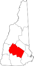 | |
| Towns | ||
| CDPs | ||
| Other unincorporated communities | ||
| Footnotes | ‡This populated place also has portions in an adjacent county or counties | |