Hook of Holland
| Hook of Holland Hoek van Holland | |
|---|---|
|
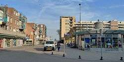
Hook of Holland town centre | |
| Coordinates: 51°58′52″N 4°7′43″E / 51.98111°N 4.12861°E | |
| Country | Netherlands |
| Province | South Holland |
| Municipality | Rotterdam |
| Population (1 July 2008)[1] | 9,382 |
| Major roads | N211 N220 |
| Dialing code | 0174 |

The Hook of Holland (Dutch: de Hoek van Holland) is a town in the southwestern corner of Holland (hence the name; hoek means "corner"), at the mouth of the New Waterway shipping canal into the North Sea. The town is administered by the municipality of Rotterdam as a district of that city. Its district covers an area of 16.7 km2, of which 13.92 km2 is land. On 1 January 1999 it had an estimated population of 9,400.
Towns near the Hook include Monster, 's-Gravenzande, Naaldwijk and Delft to the northeast, and Maassluis to the southeast. On the other side of the river is the Europort and the Maasvlakte. The wide sandy beach, one section of which is designated for use by naturists, runs for approximately 18 kilometres to Scheveningen and for most of this distance is backed by extensive sand dunes through which there are foot and cycle paths.
On the north side of the New Waterway, to the west of the town, is a pier part of which is accessible to pedestrians and cyclists.
The Berghaven is a small harbour on the New Waterway where the Rotterdam and Europort pilots are based. This small harbour is only for the use of the pilot service, government vessels and the Hook of Holland lifeboat.
During World War II this was one of the most important places for the Germans to hold because of the harbour.
Transport links
Railways
There are two railway stations, Hook of Holland Strand, which is at the end of the line and closest to the beach and Hook of Holland Haven, which is close to the town centre, adjacent to the ferry terminal and the small harbour, the Berghaven. The railway line connects the Hook to Rotterdam via Maassluis, Vlaardingen and Schiedam, the trains running every half hour during the day.
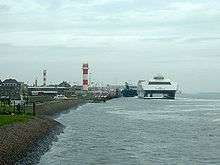
Ferry
The ferry terminal is operated by Stena Line with the passenger terminal and access for passenger cars being next to Hook of Holland Holland Haven Station and the freight entrance being to the east of the town.
A ferry service to eastern England has operated from the Hook since 1893 with only the two World Wars interrupting the service. Currently two routes are being operated: one, a day and night freight and passenger service, to Harwich, Essex and the other, a night, freight-only service to North Killingholme Haven, Lincolnshire. From 1 March 2009 the Harwich service will be departing at 2:30 pm and 10:45 pm and the Killingholme service at 9:15 pm.
A local ferry operated by RET links the Hook with the Maasvlakte part of the Port of Rotterdam.
Motorways
In just 10 kilometres one has access to the A20 heading east towards Rotterdam and Utrecht. At 17 kilometres, one could access the A4 heading north towards the Hague and Amsterdam.
References
Notes
- ↑ "Bevolkingsmonitor 2e kwartaal 2008" (PDF). Centrum voor Onderzoek en Statistiek Rotterdam. Retrieved 27 July 2008.
Bibliography
- Hendy, John; Cowsill, Miles; Brown, Stephen (2010). Harwich - Hook of Holland 1893-2010. Ramsey, Isle of Man: Ferry Publications. ISBN 9781906608101.
External links
| Wikivoyage has a travel guide for Hook of Holland. |
Boroughs of Rotterdam | ||
|---|---|---|
Coordinates: 51°58′35″N 4°07′56″E / 51.9763°N 4.1323°E