Hood County, Texas
| Hood County, Texas | ||
|---|---|---|
|
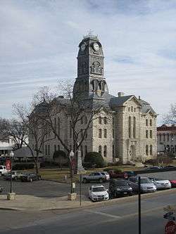
The Hood County Courthouse in Granbury | ||
| ||
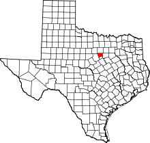 Location in the U.S. state of Texas | ||
 Texas's location in the U.S. | ||
| Founded | 1866 | |
| Named for | John Bell Hood | |
| Seat | Granbury | |
| Largest city | Granbury | |
| Area | ||
| • Total | 437 sq mi (1,132 km2) | |
| • Land | 421 sq mi (1,090 km2) | |
| • Water | 16 sq mi (41 km2), 3.7% | |
| Population | ||
| • (2010) | 51,182 | |
| • Density | 122/sq mi (47/km²) | |
| Congressional district | 11th | |
| Time zone | Central: UTC-6/-5 | |
| Website |
www | |

Hood County is a county located on the Edwards Plateau in the U.S. state of Texas. As of the 2010 census, the population was 51,182.[1] Its county seat is Granbury.[2] The county is named for John Bell Hood, a Confederate lieutenant general and the commander of Hood's Texas Brigade.
Hood County is part of the Dallas-Fort Worth-Arlington, TX Metropolitan Statistical Area and the Granbury Micropolitan Area.
History
Hood County was formed in 1866 from portions of Johnson County. It was named after John Bell Hood,[3] a general of the Confederate Army and commander of Hood's Texas Brigade.
Geography
According to the U.S. Census Bureau, the county has a total area of 437 square miles (1,130 km2), of which 421 square miles (1,090 km2) is land and 16 square miles (41 km2) (3.7%) is water.[4]
Major highways
Adjacent counties
- Parker County (north)
- Johnson County (east)
- Somervell County (south)
- Erath County (west)
- Palo Pinto County (northwest)
Demographics
| Historical population | |||
|---|---|---|---|
| Census | Pop. | %± | |
| 1870 | 2,585 | — | |
| 1880 | 6,125 | 136.9% | |
| 1890 | 7,614 | 24.3% | |
| 1900 | 9,146 | 20.1% | |
| 1910 | 10,008 | 9.4% | |
| 1920 | 8,759 | −12.5% | |
| 1930 | 6,779 | −22.6% | |
| 1940 | 6,674 | −1.5% | |
| 1950 | 5,287 | −20.8% | |
| 1960 | 5,443 | 3.0% | |
| 1970 | 6,398 | 17.5% | |
| 1980 | 17,714 | 176.9% | |
| 1990 | 28,981 | 63.6% | |
| 2000 | 41,100 | 41.8% | |
| 2010 | 51,182 | 24.5% | |
| Est. 2015 | 55,423 | [5] | 8.3% |
| U.S. Decennial Census[6] 1850–2010[7] 2010–2014[1] | |||
As of the census[8] of 2000, there were 41,100 people, 16,176 households, and 12,099 families residing in the county. The population density was 98 people per square mile (38/km²). There were 19,105 housing units at an average density of 45 per square mile (18/km²). The racial makeup of the county was 94.77% White, 0.33% Black or African American, 0.82% Native American, 0.31% Asian, 0.04% Pacific Islander, 2.40% from other races, and 1.32% from two or more races. 7.24% of the population were Hispanic or Latino of any race.
There were 16,176 households out of which 28.80% had children under the age of 18 living with them, 63.60% were married couples living together, 7.80% had a female householder with no husband present, and 25.20% were non-families. 21.60% of all households were made up of individuals and 10.00% had someone living alone who was 65 years of age or older. The average household size was 2.50 and the average family size was 2.88. As of the 2010 census, there were about 3.4 same-sex couples per 1,000 households in the county.[9]
In the county, the population was spread out with 23.60% under the age of 18, 6.70% from 18 to 24, 25.20% from 25 to 44, 26.60% from 45 to 64, and 17.90% who were 65 years of age or older. The median age was 42 years. For every 100 females there were 96.20 males. For every 100 females age 18 and over, there were 94.10 males.
The median income for a household in the county was $43,668, and the median income for a family was $50,111. Males had a median income of $38,662 versus $23,723 for females. The per capita income for the county was $22,261. About 6.00% of families and 8.50% of the population were below the poverty line, including 10.00% of those under age 18 and 7.40% of those age 65 or over.
Media
Hood County is part of the Dallas/Fort Worth Television media market in North Central Texas. Local News media outlets are: KDFW-TV, KXAS-TV, WFAA-TV, KTVT-TV, KERA-TV, KTXA-TV, KDFI-TV, KDAF-TV, KFWD-TV, and KDTX-TV. Hood County is serviced by two news media sources, "Hood County Free Press", an online daily news publication, and the bi-weekly newspaper, Hood County News.
Education
The following school districts serve Hood County:
- Bluff Dale ISD (mostly in Erath County)
- Glen Rose ISD (mostly in Somervell County)
- Godley ISD (mostly in Johnson County, small portion in Tarrant County)
- Granbury ISD (small portion in Johnson, Parker counties)
- Lipan ISD (small portion in Erath, Palo Pinto, and Parker counties)
- Tolar ISD
Politics
| Year | Republican | Democratic |
|---|---|---|
| 2016 | 81.5% 21,367 | 15.3% 4,001 |
| 2012 | 81.5% 18,409 | 17.0% 3,843 |
| 2008 | 76.5% 17,299 | 22.5% 5,087 |
| 2004 | 76.5% 16,280 | 22.9% 4,865 |
| 2000 | 71.0% 12,429 | 26.9% 4,704 |
| 1996 | 52.1% 7,575 | 37.5% 5,459 |
| 1992 | 37.5% 5,313 | 30.8% 4,359 |
| 1988 | 63.2% 7,400 | 36.3% 4,255 |
| 1984 | 68.7% 6,817 | 30.9% 3,063 |
| 1980 | 54.1% 3,755 | 43.2% 3,001 |
| 1976 | 36.7% 1,857 | 62.9% 3,181 |
| 1972 | 64.3% 1,743 | 35.0% 949 |
| 1968 | 27.4% 593 | 53.4% 1,155 |
| 1964 | 20.3% 423 | 79.6% 1,661 |
| 1960 | 43.1% 943 | 56.6% 1,238 |
Hood County has become a strongly Republican county since 1980.
Communities
Cities
- Brazos Bend
- Cresson (partly in Parker and Johnson counties)
- DeCordova
- Granbury (county seat)
- Lipan
- Tolar
Census-designated places
Unincorporated communities
See also
References
- 1 2 "State & County QuickFacts". United States Census Bureau. Retrieved December 17, 2013.
- ↑ "Find a County". National Association of Counties. Retrieved 2011-06-07.
- ↑ Gannett, Henry (1905). The Origin of Certain Place Names in the United States. Govt. Print. Off. p. 160.
- ↑ "2010 Census Gazetteer Files". United States Census Bureau. August 22, 2012. Retrieved April 30, 2015.
- ↑ "County Totals Dataset: Population, Population Change and Estimated Components of Population Change: April 1, 2010 to July 1, 2015". Retrieved July 2, 2016.
- ↑ "U.S. Decennial Census". United States Census Bureau. Retrieved April 30, 2015.
- ↑ "Texas Almanac: Population History of Counties from 1850–2010" (PDF). Texas Almanac. Retrieved April 30, 2015.
- ↑ "American FactFinder". United States Census Bureau. Retrieved 2011-05-14.
- ↑ Where Same-Sex Couples Live, June 26, 2015, retrieved July 6, 2015
- ↑ http://uselectionatlas.org/RESULTS/
External links
- Hood County Lawyer- Daniel Webb Site has some good links about Hood County.
- Hood County government's website
- Hood County from the Handbook of Texas Online
- U.S. Geological Survey Geographic Names Information System: Hood County, Texas
 |
Palo Pinto County | Parker County | | |
| Erath County | |
Johnson County | ||
| ||||
| | ||||
| Somervell County |
Municipalities and communities of Hood County, Texas, United States | ||
|---|---|---|
| Cities | | |
| CDPs |
| |
| Unincorporated communities | ||
| Footnotes | ‡This populated place also has portions in an adjacent county or counties | |

Coordinates: 32°26′N 97°50′W / 32.43°N 97.83°W