Hong Kong tropical cyclone warning signals
The Hong Kong tropical cyclone warning signals (Chinese: 熱帶氣旋警告信號), or informally typhoon signals (Chinese: 風球; Sidney Lau: fung1 kau4, literally, "wind balls"), are a set of signals used to indicate the threat or effects of a tropical cyclone. The Hong Kong Observatory issues the warning signal if a tropical cyclone approaches within 800 kilometres (500 mi) of Hong Kong and poses a threat of deteriorating conditions in Hong Kong.
The signals are represented as a set of numbers and symbols. Previously lights were also used at night.
History
The Hong Kong Observatory began issuing warnings for tropical cyclones in 1884, when it began to monitor and report news of tropical cyclones within the South China Sea, and the areas around Guam and Manila. The monitoring efforts later expanded to gathering information from various seafaring vessels. These works were done in conjunction with the Marine Department until 1886. At first, the monitoring and warning services were geared mainly towards seafarers, and not towards the residents of Hong Kong.[1]
The warning system was numerical, consisting of symbols hoisted at various places in Victoria Harbour, in the form of drums, balls, and cones. At first, the signals only gave information as to the cardinal direction from which winds were coming. Revisions of the system in 1904 added alerts as to ordinal wind direction. Until 1917, there were two sets of warning signals, one set with black symbols, and one with red. The black symbols indicated that the tropical cyclone in question was less than 300 miles (480 km) from Hong Kong, while the red symbols indicated a distance of over 300 miles (480 km).[1]
The alert system was also supplemented by the firing of guns (later cannons and bombs which, being so much louder, were considered an improvement), which became relied upon for severe weather updates, as few residents paid attention to the visual warning system intended for seafarers. Intensity was indicated by number of shots, three being an indication of a very intense cyclone. This audible alert system ended in 1937, as residents began to rely on radio, newspapers, and notices at ferry piers for tropical cyclone information.[1]
After a failed attempt at consensus with Japan over warning standards in 1917, the Observatory replaced its system with a seven-level system (four of which were ultimately converted into the four no. 8 signals used today). Attempts to convince other jurisdictions around the South China Sea to adopt this system likewise failed. It was repurposed for domestic use and, at the request of Hong Kong's Chamber of Commerce, another set of warning signals for tropical cyclones outside of Hong Kong was used concurrently by the Hong Kong Observatory until 1962.[1]
Eventually, over the years, the storm signals deviated from their original purpose of serving mariners, and became a system for the domestic population.[1] From 1 January 1973, signals 5 to 8 were replaced by 8 NW, 8 SW, 8 NE and 8 SE, respectively, so as to improve comprehensibility to the public. What had started out as a 10-level warning system had been reduced to the five-level (1,3,8,9,10) system that has been in use ever since.[2]
In the 1960s, there were 42 signal stations around the territory. The last, Cheung Chau aeronautical meteorological station on Cheung Chau, was decommissioned on 1 January 2002. Accordingly, the observatory has replaced the word hoist with issue in its official terminology, although the phrase "Signal No. __ has been hoisted" is still widely used by the public and the mass media. Weather authorities in Macao, however, still use the term "hoisted" when issuing their tropical cyclone warnings, the system of which is based heavily upon Hong Kong's.
Current system
In accordance with legal codes and custom in Hong Kong, once any signal higher than No. 3 is issued, all government agencies shut down their operations, schools immediately cease classes, financial markets and most of the private sector close their doors. Non-essential workers are released from work in a staggered manner so as to avoid overwhelming public transportation. Public transit agencies that operate on the sea or on surface streets and highways generally continue to operate initially but may cease operation at short notice. Employers who require staff to remain on duty during a No. 8 or higher signal must provide a safe work environment and shelter after work should transportation be unavailable. Such arrangements must be worked out beforehand between the employer and employee.[3] In order to minimise disruption, the Hong Kong Observatory has, since 1987, observed a practice of issuing warnings two hours in advance of the issuance of the No. 8 warning signal, though such warnings of warnings are not attended by any system of numbering such as to indicate the relative imminence of issuance of the typhoon warning signal itself.[4]
In its early days, as a system devised for the service of mariners, it relied upon wind speeds measured around Victoria Harbour. As the emphasis shifted to serving the intensively urbanised populace, such observations were seen as lacking relevance.[5] The Hong Kong Observatory was the target of criticism during Typhoon Prapiroon in 2006 when conditions in urban areas were much more severe than those on the harbour which had justified only a No. 3 signal being issued. In response, from 2007, the Hong Kong Observatory broadened its network to eight near sea-level reference anemometers around Hong Kong.[6]
Meaning of signals
The Saffir–Simpson hurricane wind scale is a classification used for some Western Hemisphere tropical cyclones. However Hong Kong has a similar official five-level definition of the signals based on the Beaufort Scale, as shown in the table below.
The highest level, Hurricane Signal No. 10, is rarely issued. There have been only 14 No. 10 warnings since 1946, and only 2 since 1984 (Typhoon York in 1999, and Severe Typhoon Vicente in 2012).[7] Prior to 1983, No. 10 warnings occurred at more frequent intervals of 4 years or less.
| Signal Number |
Signal Name |
Sustained Wind Speed (km/h, (mph, Beaufort scale)) |
Gusts (km/h (mph)) |
Signal Sign |
Light Signal (No longer in use) |
Remark |
|---|---|---|---|---|---|---|
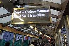
| 1 | Standby (戒備) |
N/A | N/A |  |
|
A tropical cyclone is centred within 800 kilometres of Hong Kong and may later affect the territory, or strong winds are blowing over offshore waters.[8] |
| 3 | Strong Wind (強風) |
41 – 62 (26–37, Beaufort Force 6–7) | may exceed 110 (69) |  |
|
Strong winds are expected or blowing generally in Hong Kong near sea level, and the wind condition is expected to persist |
| 8 NE | Gale or Storm (烈風或暴風) |
63 – 117 (38–73, Beaufort Force 8–11) | may exceed 180 (113) |  |
|
Gale or storm force winds are expected or blowing generally in Hong Kong near sea level from the NE quadrant, and the wind condition is expected to persist |
| 8 NW |  |
|
Gale or storm force winds are expected or blowing generally in Hong Kong near sea level from the NW quadrant, and the wind condition is expected to persist | |||
| 8 SE |  |
|
Gale or storm force winds are expected or blowing generally in Hong Kong near sea level from the SE quadrant, and the wind condition is expected to persist | |||
| 8 SW |  |
|
Gale or storm force winds are expected or blowing generally in Hong Kong near sea level from the SW quadrant, and the wind condition is expected to persist | |||
| 9 | Increasing Gale or Storm (烈風或暴風增強) |
88 – 117, increasing (55–73, Beaufort Force 10–11) | N/A |  |
|
Gale or storm force winds are increasing or expected to increase significantly in strength. |
| 10 | Hurricane (颶風) |
>118 (74+, Beaufort Force 12) | may exceed 220 (138) |  |
|
Hurricane-force winds expected or blowing anywhere near sea level in Hong Kong. Eye of typhoon may be passing very close or directly over Hong Kong. |
Macau counterpart
In Macau, the territory's Meteorological and Geophysical Bureau maintains a very similar system.[9] The bureau has maintained the practice of hoisting the warning signals (as well as its nighttime light signals), even as Hong Kong abandoned the practice in 2002. The signals are hoisted at Guia Fortress and the Fortaleza do Monte.
See also
References
- 1 2 3 4 5 "Modernisation of The City" (PDF) (in Chinese and English). Hong Kong Observatory. 2003. p. 68. Retrieved 24 August 2008.
- ↑ "History of the Hong Kong Tropical Cyclone Warning Signals". Hong Kong Observatory.
- ↑ "Code of Practice in times of Typhoons and Rainstorms" (PDF). Labour Department.
- ↑ "Related Advisory Information and Arrangements from Bureaux and Departments in Tropical Cyclone Situations". Hong Kong Observatory.
- ↑ "Regional Wind Information". Hong Kong Observatory.
- ↑ "Review of the Tropical Cyclone Warning System in 2006 and New Measures in 2007" (PDF). Hong Kong Observatory.
- ↑ http://www.hko.gov.hk/cgi-bin/hko/warndb_e1.pl?opt=1&sgnl=10&start_ym=194609&end_ym=201208&submit=Submit+Query
- ↑ http://www.hko.gov.hk/blog/en/archives/00000182.htm
- ↑ "Meaning of Tropical Cyclone Signals and the relevant recommended safety precautions". Macao Meteorological and Geophysical Bureau. Retrieved 15 July 2013.
External links
- Hong Kong's Tropical Cyclone Warning Signals
- Tropical Cyclone Warning Signals of Macao
- The day/night signals