Holly Recreation Area
| Holly Recreation Area | |
|---|---|
|
Heron Lake Beach Area | |
 Location within the state of Michigan | |
| Location | Lower Peninsula, Oakland County, Michigan USA |
| Nearest city | Holly, Michigan |
| Coordinates | 42°48′52″N 83°32′33″W / 42.81444°N 83.5425°WCoordinates: 42°48′52″N 83°32′33″W / 42.81444°N 83.5425°W |
| Area | 7,817 acres (3,163 ha) |
| Governing body | Michigan Department of Natural Resources |
| http://www.dnr.state.mi.us/parksandtrails/details.aspx?id=459&type=SPRK | |
Holly Recreation Area is a state-run park in Groveland Township, near Holly, Michigan.
Park Information
Covering 7,817 acres (3,163 ha) of rolling woodland and open fields, the park area is bisected by Dixie Highway and Interstate 75, with a majority of park features to the east, and the Holdbridge Lakes Mountain Bike Area to the west, featuring the Gruber's Grinder trail. Features include an 18-hole disc golf course, 35 miles (56 km) of hiking and mountain biking trails, a model airplane flying field, opportunities for swimming, fishing, boating, and hunting. Winter activities include cross-country skiing and snowmobiling. Camping is provided for at 160 campsites and 3 rustic cabins, one of which is the Rolston Cabin. There is a groomed beach with picnic tables, a snack bar, and boat rentals on Heron Lake. The park area also encompasses McGinnis Lake, Valley Lake, and Wildwood Lake.
The park typically sees the highest number of visitors in August and September, coinciding with the Michigan Renaissance Festival, which is located near the park.
The area is managed by the Michigan Department of Natural Resources.
Gallery
-
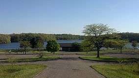
Heron Lake Beach Area
-
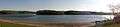
Lakeshore Trail
-

Rolston Cabin
See also
- Seven Lakes State Park, a nearby state park
External links
- Holly Recreation Area Michigan Department of Natural Resources
- Holly Game Unit of Holly Recreation Area Protected Planet (World Database on Protected Areas)