Hoge Kempen National Park
| Hoge Kempen National Park | |
|---|---|
|
IUCN category II (national park) | |
|
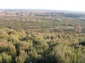
Heathland in the Hoge Kempen | |
 Location of Hoge Kempen National Park | |
| Location | Limburg, Flemish Region, Belgium |
| Nearest city | Genk |
| Coordinates | 51°00′N 5°40′E / 51.000°N 5.667°ECoordinates: 51°00′N 5°40′E / 51.000°N 5.667°E |
| Area | 57.50 square kilometres (22.20 sq mi) |
| Established | 2006 |
| Visitors | 700.000 (in 2010) |
| Governing body | Agentschap voor Natuur en Bos |
The Hoge Kempen National Park (Nationaal Park Hoge Kempen) is the first National Park in Flanders, Belgium. It is located in the East of the Province of Limburg, between Genk and the Meuse River (Dutch: Maas) Valley. It includes the elevated ground that defines the watershed between that river and the low ground of the drainage basin of the Demer river that covers most of Belgian Limburg.
It was opened in March 2006.[1] Covering almost 60 square kilometres, it forms part of the Natura 2000 network.[2] The area is mostly heathland and pine forest. In May 2011 it was placed on UNESCO's Tentative List for consideration as a World Heritage Site.
See also
- Kempen also known as De Kempen, a region in Belgium and the Netherlands, also called Kempenland or Campine.
References
- ↑ "First National Park opened – Milestone for Belgium's Countdown 2010". countdown2010. 2006-03-23. Retrieved 2008-09-18.
- ↑ "The National Park Hoge Kempen" (pdf). Eurosite. Retrieved 2008-09-18.
External links
| Wikimedia Commons has media related to National park Hoge Kempen. |
This article is issued from Wikipedia - version of the 11/19/2016. The text is available under the Creative Commons Attribution/Share Alike but additional terms may apply for the media files.