Hof, Vestfold
| Hof kommune | |||
|---|---|---|---|
| Municipality | |||
 | |||
| |||
 Hof within Vestfold | |||
| Coordinates: 59°33′56″N 10°2′10″E / 59.56556°N 10.03611°ECoordinates: 59°33′56″N 10°2′10″E / 59.56556°N 10.03611°E | |||
| Country | Norway | ||
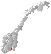
| County | Vestfold | ||
| Administrative centre | Hof | ||
| Government | |||
| • Mayor (2015) | Mette Måge Olsen (Ap) | ||
| Area | |||
| • Total | 163 km2 (63 sq mi) | ||
| • Land | 148 km2 (57 sq mi) | ||
| Area rank | 353 in Norway | ||
| Population (2009) | |||
| • Total | 3,058 | ||
| • Rank | 270 in Norway | ||
| • Density | 20/km2 (50/sq mi) | ||
| • Change (10 years) | 11.2 % | ||
| Time zone | CET (UTC+1) | ||
| • Summer (DST) | CEST (UTC+2) | ||
| ISO 3166 code | NO-0714 | ||
| Official language form | Bokmål | ||
| Website |
www | ||
|
| |||

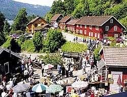
Hof is a municipality in Vestfold county, Norway. The administrative centre of the municipality is the village of Hof. The municipality of Hof was established on 1 January 1838 (see formannskapsdistrikt). Hof had 3,031 inhabitants as of 1 January 2002.
General information
Name
The municipality (originally the parish) is named after the old Hof farm (Old Norse: Hof), since the first church was built here. The name is identical with the word hof which means "pagan temple (for the Norse Gods)".[1]
Coat-of-arms
The coat-of-arms is from modern times. They were granted on 17 July 1992. The arms show three gold-colored water lily leaves on a red background. This was chosen to represent the many small lakes in the municipality. There are three to represent the three church parishes in the municipality. It was designed by Geir Helgen from Buskerud.[2]
Geography
The municipality of Hof covers 164 square kilometres (63 sq mi), of which 140 square kilometres (54 sq mi) is land, 17.9 square kilometres (6.9 sq mi) is farmland and 125.1 square kilometres (48.3 sq mi) is forests. The municipality consists of the three parishes of Hof, Eidsfoss, and Sundbyfoss. The highest point in Vestfold, Skibergfjell, is located in the northern part of Hof municipality, close to Eidsfoss. Skibergfjell is 632 metres (2,073 ft).
Economy
Hof is a typical agricultural and forestry municipality and its largest industry is a lumber mill. Hof lies in the climate zone best suited for agriculture in Norway. Therefore, wheat is one of the most important agricultural products of the municipality. However, between 1998 and 2008, 40% of the municipality's farms have become inactive, and the agriculture employment rate has dropped to 5,3%. Within the next 10 to 20 years an increased utilization of the municipality's forests is expected (stated August 2008).[3]
Hof is known for its great hunting and fishing resources. 120,000 acres (490 km2) of forest are open for hunting. The hunting is commercialized. About 75 landowners are united in a land owner union (Hof Utmarkslag), and hunters must purchase permits from them (mainly small game hunting).[4]
Annual rates of felled game (2007):[5]
References
- ↑ Rygh, Oluf (1907). Norske gaardnavne: Jarlsberg og Larviks amt (in Norwegian) (6 ed.). Kristiania, Norge: W. C. Fabritius & sønners bogtrikkeri. p. 53.
- ↑ "Kommunevåpen" (in Norwegian). Hof kommune. Retrieved 2009-01-13.
- ↑ http://www.hof.kommune.no/Tjenester/Landbruk/Om-landbruket-i-Hof-kommune/
- ↑ http://www.hof.kommune.no/Tjenester/Landbruk/Fiske--og-viltforvaltning/Jakt/
- ↑ http://www.hof.kommune.no/Tjenester/Landbruk/Fiske--og-viltforvaltning/Jakt/
External links
-
 Media related to Hof at Wikimedia Commons
 -
 The dictionary definition of Hof at Wiktionary
 - Municipal fact sheet from Statistics Norway
-
 Vestfold travel guide from Wikivoyage
 - Hofnett (Norwegian)
- Eidsfoss (Norwegian)
- Visiteidsfoss (Norwegian)
- Hofposten (Norwegian)
- Vestfoldnett (Norwegian)
- Eikeren (Norwegian)