Hochheim am Main
| Hochheim am Main | ||
|---|---|---|
| ||
 Hochheim am Main | ||
Location of Hochheim am Main within Main-Taunus-Kreis district 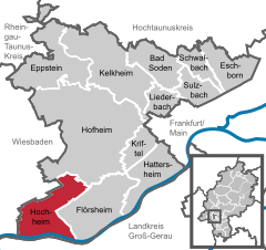
 | ||
| Coordinates: 50°1′0″N 8°21′0″E / 50.01667°N 8.35000°ECoordinates: 50°1′0″N 8°21′0″E / 50.01667°N 8.35000°E | ||
| Country | Germany | |
| State | Hesse | |
| Admin. region | Darmstadt | |
| District | Main-Taunus-Kreis | |
| Government | ||
| • Mayor | Dirk Westedt (FWG) | |
| Area | ||
| • Total | 19.43 km2 (7.50 sq mi) | |
| Population (2015-12-31)[1] | ||
| • Total | 17,057 | |
| • Density | 880/km2 (2,300/sq mi) | |
| Time zone | CET/CEST (UTC+1/+2) | |
| Postal codes | 65239 | |
| Dialling codes | 06146 | |
| Vehicle registration | MTK | |
| Website | www.hochheim.de | |

Hochheim am Main is a town in the Main-Taunus district of the German state of Hesse. It is located near the right bank of the Main River three miles above its confluence with the Rhine, as well as on the German Timber-Frame Road.
There is a historical reference to Hochheim in the chronicles as early as the 8th century. Hochheim is the site of an Austrian military victory over the French Empire on 7 November 1813.
Located in the Rheingau, Hochheim has historically been a centre of the wine trade. The English word "hock", a generic term for Rhine wine, is derived from Hochheim.
Local children attend school in Hochheim until the Year 11 (UK) or 10th grade (US). After that, if they choose to continue with their education, they have to attend schools in Wiesbaden or Mainz. Hochheim's twin towns are Le Pontet and Waupaca, Wisconsin
 Old Town of Hochheim am Main with the old cemetery
 South of Hochheim am Main
Noted residents
- Anne Heitmann, Poet
- Elena Heller, Artist
References
- ↑ "Bevölkerung der hessischen Gemeinden". Hessisches Statistisches Landesamt (in German). August 2016.
From the 1911 Encyclopædia Britannica
- Schüler, Geschichte der Hochheim am Main (Hochheim, 1888)
External links
- Official website of the government of Hochheim, in German
- There is literature about Hochheim am Main in the Hessian Bibliography
- Cultural monuments in Hochheim am Main (185 data entries)
- Literature by and about Hochheim am Main in the German National Library catalogue
- Hochheim am Main at DMOZ
- digitalised version of the Hochheimer Stadtanzeiger (local paper) 1911–1932
- Postal history, philately, postcards and archives
![]() This article incorporates text from a publication now in the public domain: Chisholm, Hugh, ed. (1911). "article name needed". Encyclopædia Britannica (11th ed.). Cambridge University Press.
This article incorporates text from a publication now in the public domain: Chisholm, Hugh, ed. (1911). "article name needed". Encyclopædia Britannica (11th ed.). Cambridge University Press.
Towns and municipalities in Main-Taunus-Kreis district | ||
|---|---|---|