Hiva Oa
|
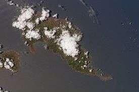
The island of Hiva Oa. Atuouna is located on the large bay on the south side of the island. | |
 Location of Hiva Oa within the Marquesas Islands | |
| Geography | |
|---|---|
| Location | South Pacific Ocean |
| Coordinates | 9°45′S 139°00′W / 9.750°S 139.000°WCoordinates: 9°45′S 139°00′W / 9.750°S 139.000°W |
| Archipelago | Marquesas Islands |
| Area | 316 km2 (122 sq mi) |
| Highest elevation | 1,213 m (3,980 ft) |
| Highest point | Temetiu |
| Administration | |
| Overseas country | French Polynesia |
| Demographics | |
| Population | 2,190 (2012) |
| Pop. density | 6.9 /km2 (17.9 /sq mi) |
With its 320 square kilometres (124 square miles), Hiva Oa is the second largest island in the Marquesas Islands, in French Polynesia, an overseas territory of France in the Pacific Ocean. It is the largest island of the southern Marquesas group, housing only 2,200 people and located at 9 45' south latitude and 139 W longitude. The volcano Temetiu is its highest point with 1,200 metres (3,937 feet).
According to local religion, the gods created the Marquesas as their home. Therefore, all islands have names that are related with the building of a house - Hiva Oa means long ridgepole.
Overview
Administratively, Hiva Oa is part of the commune (municipality) of Hiva-Oa, itself in the administrative subdivision of the Marquesas Islands. Atuona, on the coast of Hiva Oa island, is the administrative centre of the commune. Atuona was formerly the seat of government for all of the Marquesas Islands, but it has been replaced by Taiohae on Nuku Hiva island.
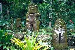
The island is famous as the final home of French painter Paul Gauguin and Belgian singer Jacques Brel, both of whom are buried in Calvary Cemetery, overlooking Atuona. It is also home to the largest tiki sculptures in French Polynesia.[1]
In late pre-European times, the island was nearly evenly divided into two provinces—Nuku in the west, and Pepane in the east.
Geography
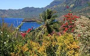
Hiva Oa is the largest and most fertile of the southern Marquesas islands and second only to Nuku Hiva in size. Similar to all the larger Marquesas, Hiva Oa features steep cliffs abruptly rising from the ocean to a rugged interior spine of volcanic mountains, ridges, and deep, isolated valleys. Unlike most other Polynesian islands near the equator, no fringing coral reefs protect Hiva Oa from the pounding of the ocean and only a few sheltered anchorages and sandy beaches are scattered around the coast. Travel along the shoreline is by boat as most of the coastal terrain is too rugged for roads. A few dirt roads traverse the interior and link seacoast villages and settlements.[2] Atuona Airport is located at an elevation of 1,481 feet (451 m) on a plateau near the center of the island and has an asphalt-surfaced runway 3,986 feet (1,215 m) long with daily flights to other Marquesas islands and Tahiti.[3]
The outstanding geologic characteristic of Hiva Oa is the collapsed volcano Temetiu. Semi-circular Ta'a Oa bay, also called the Bay of Traitors, is in the crater of the volcano whose walls rise sharply 1,000 metres (3,300 ft) above the bay. Within Ta'a Oa are Atuona Bay and adjacent Taha Uku which are the best anchorages on the island. Taha Uku has a protective seawall built in 1981.[4]
Hiva Oa is separated from the nearby island of Tahuata to its south by a 2.5 miles (4.0 km) wide channel called Ha'ava or the Canal de Bordelais.
Climate
Temperatures in the Marquesas are stable year around, but precipitation is highly variable. Precipitation is much greater on the north and east (windward) parts of the islands and much less on the western (leeward) parts. Droughts, sometimes lasting several years, are frequent and seem to be associated with the El Niño phenomena.[5] The highest annual rainfall recorded in Atuona is 148.2 inches (3,760 mm); the lowest is 22 inches (560 mm).[6]
| Climate data for Atuona, Hiva Oa | |||||||||||||
|---|---|---|---|---|---|---|---|---|---|---|---|---|---|
| Month | Jan | Feb | Mar | Apr | May | Jun | Jul | Aug | Sep | Oct | Nov | Dec | Year |
| Average high °C (°F) | 30 (86) |
31 (87) |
31 (87) |
31 (87) |
29 (85) |
29 (84) |
28 (83) |
28 (83) |
29 (84) |
29 (85) |
30 (86) |
30 (86) |
29 (85) |
| Daily mean °C (°F) | 27 (81) |
27 (81) |
28 (82) |
28 (82) |
27 (80) |
26 (79) |
26 (78) |
26 (78) |
26 (79) |
26 (79) |
27 (80) |
27 (81) |
27 (80) |
| Average low °C (°F) | 23 (74) |
24 (75) |
24 (76) |
24 (76) |
24 (75) |
23 (74) |
23 (74) |
23 (73) |
23 (73) |
23 (73) |
23 (74) |
23 (74) |
23 (74) |
| Average precipitation mm (inches) | 114 (4.5) |
91 (3.6) |
112 (4.4) |
117 (4.6) |
122 (4.8) |
175 (6.9) |
122 (4.8) |
100 (4) |
157 (6.2) |
79 (3.1) |
66 (2.6) |
89 (3.5) |
1,293 (50.9) |
| Source: Weatherbase [7] | |||||||||||||
Population
In 2012, the population of Hiva Oa was 2,190, of which 1,845 lived in the commune of Acounda and 345 in the village of Puama'u.[8] The inhabitants speak the southern Marquesan language, related to other Polynesian languages, and French.
History
The first recorded sighting of Hiva Oa by the Europeans was by the Spanish expedition of Álvaro de Mendaña on 21 July 1595. They charted it as Dominica.[9]
See also
References
- ↑ "Marquesas Islands". Marquesas Islands. Go Tahiti. Retrieved 14 February 2014.
- ↑ Gillespie, Thomas W. "Marquesas Islands: Tropical Dry Forests of the Pacific" http://www.sscnet.ucla.edu/geog/tdfpacific/marquesas_islands.html, accessed 4 Dec2013; Google Earth
- ↑ http://www.airgorilla.com/airports/pacific/french-polynesia/hiva-oa-marquesas-hix.html, accessed 4 Dec 2013
- ↑ "Hiva Oa" http://www.crwflags.com/fotw/flas/pf-mq-ho.html, accessed 4 Dec 2013
- ↑ Addison, David J. "Traditional Agriculture of the Marquesas Islands (French Polynesia)" Rapa Nui Journal 21.2 (2007): 111-27.
- ↑ Florence, Jacques and Lorence, David H. "Introduction to the Flora and Vegetation of the Marquesas Islands" Allertonia, Vol. 7, No. 4, p. 223
- ↑ "Weatherbase: Historical Weather for Atuona, French Polynesia". Weatherbase. 2011. Retrieved on November 24, 2011.
- ↑ La population légale au 22 août 2012
- ↑ Sharp, Andrew The discovery of the Pacific Islands Clarendon Press, Oxford, 1960, p.51.
External links
| Wikivoyage has a travel guide for Hiva Oa. |
| Northern Marquesas: | |||
|---|---|---|---|
| Southern Marquesas: | |||