Hita, Ōita
| Hita 日田市 | ||
|---|---|---|
| City | ||
|
Hita Gion Festival, held in July. | ||
| ||
 Location of Hita in Ōita Prefecture | ||
 Hita Location in Japan | ||
| Coordinates: 33°19′N 130°56′E / 33.317°N 130.933°ECoordinates: 33°19′N 130°56′E / 33.317°N 130.933°E | ||
| Country | Japan | |
| Region | Kyushu | |
| Prefecture | Ōita Prefecture | |
| Government | ||
| • Mayor | Yōichi Satō | |
| Area | ||
| • Total | 666.19 km2 (257.22 sq mi) | |
| Population (December 31, 2011) | ||
| • Total | 71,537 | |
| • Density | 107.38/km2 (278.1/sq mi) | |
| Symbols | ||
| • Tree | Camellia sasanqua | |
| • Flower | Iris | |
| • Bird | Sekirei (Motacillidae) | |
| Time zone | Japan Standard Time (UTC+9) | |
| City hall address |
2-6-1, Tajima, Hita-shi, Ōita-ken 877-8601 | |
| Website |
www | |


Hita (日田市 Hita-shi) is a city located in Ōita Prefecture, Japan, that was founded on December 11, 1940. It is an agricultural and industrial centre that primarily produces lumber, furniture, and pottery. Its attractions and scenic beauty also make it a popular tourist destination.
On March 22, 2005, the towns of Amagase and Ōyama, and the villages of Kamitsue, Maetsue and Nakatsue (all from Hita District) were merged into Hita.
As of December 31, 2011, the city has an estimated population of 71,537, with 26,846 households, and a population density of 107.38 persons per km². However, the estimated population of central Hita is about 5,000 people. The total area of the city is 666.19 km².
Geography
Hita is located in the far west of Ōita Prefecture, and borders the neighbouring prefectures of Fukuoka, and Kumamoto. Surrounding cities include Kurume to its west, Nakatsu to the north, and Kusu to the east. Hita itself lies in a plain at the confluence of several rivers that flow west, eventually becoming the Chikugo River. The surrounding landscape is mountainous, typical of Ōita Prefecture. Due to this connection, although Hita is placed within Ōita Prefecture, it shared a deeper historical connection with Fukuoka Prefecture. The dialect used in Hita has the same characteristic to the Hichiku dialect, used in Fukuoka, Nagasaki and Saga Prefecture.
Many rivers that run through Hita join up to the Mikuma River. This river was used to distribute lumber to Kurume and Ōkawa at the end of the Edo Period but with the completion of the Yoake Dam, the use of this route stopped.
Hita is a natural basin surrounded by mountains, reaching 1000 meters (3,281 ft) above sea level, while some mountains around Nakatsue, Maetsue and Kamitsue reach 1200 meters (3,937 ft) above sea level.
Climate

Hita has a humid subtropical climate (Köppen climate classification Cfa). The mountains around Hita cause the air to be very stagnant, causing summer to get very hot, rising above 35 °C (95 °F) often. While in winter, it gets notably cold. When it snows, snow can accumulate up to 10 centimetres (3.9 in) inside the city, while in the mountain region, it accumulates more.
The numbers of Thunderstorms are also very prominent in Hita. The precipitation rate is high, while it helps grow the Japanese Cedar and the Lever trees used in the forestry industry, it also causes landslides.
The rivers and the characteristics of the basin cause a deep fog during spring and autumn, known as “Sokogiri” (Shallow ground fog) to appear in the morning. “Sokogiri” is a very dark fog, where you can't see anything for miles.
| Climate data for Hita, Ōita | |||||||||||||
|---|---|---|---|---|---|---|---|---|---|---|---|---|---|
| Month | Jan | Feb | Mar | Apr | May | Jun | Jul | Aug | Sep | Oct | Nov | Dec | Year |
| Average high °C (°F) | 8.8 (47.8) |
10.2 (50.4) |
14.6 (58.3) |
20.8 (69.4) |
25.1 (77.2) |
27.9 (82.2) |
31.5 (88.7) |
32.6 (90.7) |
28.5 (83.3) |
23.1 (73.6) |
17.4 (63.3) |
11.6 (52.9) |
21.01 (69.82) |
| Daily mean °C (°F) | 3.3 (37.9) |
4.4 (39.9) |
7.9 (46.2) |
13.9 (57) |
18.3 (64.9) |
22.1 (71.8) |
26.2 (79.2) |
26.6 (79.9) |
22.6 (72.7) |
16.3 (61.3) |
10.5 (50.9) |
5.2 (41.4) |
14.78 (58.59) |
| Average low °C (°F) | −1.2 (29.8) |
−0.4 (31.3) |
2.0 (35.6) |
7.7 (45.9) |
12.2 (54) |
17.4 (63.3) |
22.1 (71.8) |
22.2 (72) |
18.2 (64.8) |
10.9 (51.6) |
5.2 (41.4) |
0.4 (32.7) |
9.73 (49.52) |
| Average precipitation mm (inches) | 70.2 (2.764) |
82.5 (3.248) |
110.7 (4.358) |
148.8 (5.858) |
172.5 (6.791) |
324.7 (12.783) |
323.4 (12.732) |
194.0 (7.638) |
159.8 (6.291) |
92.7 (3.65) |
66.3 (2.61) |
48.8 (1.921) |
1,794.4 (70.644) |
| Average snowfall cm (inches) | 15 (5.9) |
8 (3.1) |
2 (0.8) |
0 (0) |
0 (0) |
0 (0) |
0 (0) |
0 (0) |
0 (0) |
0 (0) |
0 (0) |
4 (1.6) |
29 (11.4) |
| Average relative humidity (%) | 78 | 77 | 74 | 73 | 74 | 77 | 79 | 78 | 80 | 80 | 81 | 80 | 77.6 |
| Mean monthly sunshine hours | 104.7 | 110.6 | 150.3 | 160.4 | 178.6 | 136.4 | 167.4 | 193.9 | 146.6 | 157.5 | 122.3 | 106.2 | 1,734.9 |
| Source: NOAA (1961-1990) [1] | |||||||||||||
Towns and villages
Towns and villages of note that lie within Hita's boundaries include:
- Amagase: Popular hot-spring spa town
- Maetsue; Mountain village
- Nakatsue: Mountain village
- Kamitsue: Home to international racing circuit Autopolis
- Ōyama: Agricultural town famous for ume and mushrooms
- Onta: Scenic pottery village producing distinct Japanese pottery called Onta ware (Onta-yaki)
For the municipal timeline of Hita, see Hita District (Japanese). Hita has shared borders with the former Hita District since 1889.
History
In 1593, Hita came under the direct control of the Toyotomi Household as the main city overseeing Kyushu. After the completion of Hinokuma castle and fortification of Nagayama castle, Hita passed from the Toyotomi household to the new Daimyo Tokugawa Ieyasu and became a "Tenryo" town, in which the town was under direct control of the Tokugawa Shogunate. After the Meiji period it was known as Hita Prefecture, and after that, it was assimilated into Ōita Prefecture.
Culture
During the Edo period, Hita was modeled after Kyoto and its merchant culture, and even now, it is called "Little Kyoto". Traces of old Kyoto are apparent in the streets of Mameda. It also has a school built by Hirose Tansou, where students from all over Japan came to learn regardless of their gender or status.
Economy

Traditional crafts
- Wooden geta, made from the trees surrounding Hita.
- Onta ware, created in the mountain village of Sarayama, the technique creating the Onta ware is listed as one of Living National Treasures of Japan.
Main Trade
Key industry in Hita have been forestry due to its abundant supply in the surrounding mountains. The trees planted are also given the name Hita Cedar trees and from these trees, Geta and Lacquerware have also flourished.
Recently, companies such as TDK, Kyushu Sumidenso, as well as brewery Sapporo beer and Sanwa Shurui have expanded in the area.
Transportation
Train
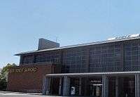
The principal railway station of the city is Hita Station, where JR Kyushu, Kyūdai Main Line and Hitahikosan Line gathers.
The luxury Aru Ressha train was designed by Eiji Mitooka. It runs between Ōita and Hita and is in service to also revive tourism and the local economy.[2]
Bus
There are three main bus service companies in Hita. The Hita Bus Company operates bus routes within the city and to other main cities in Kyushu, such as Ōita and Fukuoka city with Ōita Transportation Company. The Nishitetsu Bus Kurume Company operates bus routes within Fukuoka Prefecture, Saga Prefecture, to Hita. The Bus information center is located across the road from the station, which handles tickets and timetables.
Sightseeing

Hita has many places of interest to visitors. The Gion Festival Centre in Kuma-machi provides information about the history and activities of Hita's annual summer festival, and exhibits six full-sized floats which are paraded around the city during the annual Gion Festival.
From July to November, fishermen erect bamboo fish traps (ayuyana) in the Mikuma river to capture Ayu fish; which are covered in salt and grilled.
Hita also has the Sapporo Beer factory, located on a hill overlooking the city. There is a free guided tour for visitors that is followed by a free 20-minute tasting session.
The Kusano family Hina Dolls can be viewed at the oldest house in Hita during the tourist season. In the March Doll's Festival, up to 200 of the collection are on display at once.
Locations and landmarks
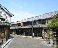
- Mameda town (豆田町): The town preserved from the Tenryo period, where it was under the direct rule by the Tokugawa Shogunate.
- Hirose Museum (廣瀬資料館)
- Kusano House (草野本家)
- Nihongan Medicinal Museum
- Tenryo Hita Museum (天領日田資料館)
- Kuncho Sake Brewery Museum (クンチョウ酒蔵資料館)
- Shizantei Museum (市山亭懐古館)
- Kangien (咸宜園跡)
- Hita Gion Museum (日田祇園山鉾会館)
- Reimeikan (黎明館・押し花美術館)
- Yahata House(旧矢羽田家住宅)
- Gyotoku House (行徳家住居)
- Seikei Library (清渓文庫)
- Sara Mountain (皿山)
- Taio gold mine (鯛生金山)
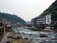
Hot Springs

- Hita Hot Springs (日田温泉)
- Tsugo Hot springs (津工温泉)
- Kazeno Hot Springs (風の湯)
- Umenokao Hot Springs (梅の香温泉)
- Amagae Hot Springs (天ヶ瀬温泉)
- Yunotsuru Hot Springs (湯ノ釣温泉)
Shrines and temples
- Hita Shrine (日田神社 Hita Jinja)
- Ōhara Hachiman Shrine (大原八幡宮 Ōhara Hachimangū)
- Ōno Oimatsu Shrine (大野老松天満社 Ōno Oimatsu Tenmansha)
- Takatsuka Atago Shrine
- Denraiji Temple (伝来寺)
- Gakurinji Temple
- Jigenzan Yokoji Temple (慈眼山永興寺)
Parks
- Tsukikuma Park (月隈公園)
- Kizan Park (亀山公園)
- Yokoji Park - Hita Castle (慈眼山公園)
- Tsubakinohana Highland Park (椿ヶ鼻ハイランドパーク)
- Kagamizaka Park (鏡坂)
- Hagio Park (萩尾公園)
Festivals

Hita has many festivals throughout the year that attract a steady stream of visitors. Some of the most popular festivals include:
- Hina Dolls Festival (February/March): During the national Doll's Festival the museums and old houses of Mameda-machi and Kuma-machi open their doors to the public and display their collection of dolls.
- Cherry Blossom Festival (First Sunday in April): Kizan Park hosts Hita's Cherry Blossom-viewing (Hanami) event, during which people may enjoy a stroll by the river and drink under the blossom trees.
- River Opening Festival (First weekend after May 20): A two-day firework display that launches more than 10,000 fireworks over the Mikuma river. The display may be viewed from a riverboat.
- Gion Festival (First Sunday after July 20): Huge wooden floats (up to 12m high) from different areas of the city are pushed around the streets by volunteers.
- Tenryo Festival (Third weekend in October): This festival celebrates Hita's Edo period, when it was under direct Tokugawa supervision. The highlight is a procession of 200 people through the city in full Edo-period costume. The name of the festival comes from the phrase tenryō, used to describe such direct Tokugawa landholdings (Hita was part of the territory overseen by the saigoku gundai, the deputy of the western provinces).
References
- ↑ "Hita Climate Normals 1961-1990". National Oceanic and Atmospheric Administration. Retrieved January 6, 2013.
- ↑ http://www.japantimes.co.jp/news/2015/08/08/national/luxury-dream-train-designed-over-100-years-ago-goes-into-service-in-kyushu/#.VeV_hn3Qgse
External links
| Wikimedia Commons has media related to Hita, Oita. |
| Wikivoyage has a travel guide for Hita. |
- Hita City official website (Japanese)