History of Toronto
Part of a series on the |
||||||||||||||||
|---|---|---|---|---|---|---|---|---|---|---|---|---|---|---|---|---|
| History of Toronto | ||||||||||||||||
 | ||||||||||||||||
| History | ||||||||||||||||
|
||||||||||||||||
| Events | ||||||||||||||||
|
||||||||||||||||
| Other | ||||||||||||||||
|
| ||||||||||||||||

The history of Toronto, Canada begins several millennia ago. Archaeological finds in the area have found artifacts of First Nations settlements dating back several thousand years. The Wyandot people were likely the first group to live in the area, followed by the Iroquois. When Europeans first came to Toronto, they found a small village known as Teiaiagon on the banks of the Humber River. Between visits by European explorers, the village was abandoned by the Iroquois, who moved south of Lake Ontario and the Mississaugas, a branch of the Ojibwa settled along the north shore of the lake.
The French first set up trading posts in the area, including Fort Rouillé in 1750, which they abandoned as the British conquered French North America. In 1786, Lord Dorchester arrived in Quebec City as Governor-in-Chief of British North America. His mission was to solve the problems of the newly landed Loyalists from the United States after the US War of Independence. At first, Dorchester suggested opening the new Canada West as districts under the Quebec government, but the British Government made known its intention to split Canada into Upper and Lower Canada. Dorchester began organizing for the new province of Upper Canada, including a capital. Dorchester's first choice was Kingston, but was aware of the number of Loyalists in the Bay of Quinte and Niagara areas, and chose instead the location north of the Bay of Toronto, midway between the settlements and 30 miles (48 km) from the US. Under the policy of the time, the British recognized aboriginal title to the land and Dorchester arranged to purchase the lands from the Mississaugas.[1] A provisional Upper Canada government was set up in Newark (today's Niagara-on-the-Lake) in 1791.
In 1793, Lieutenant Governor John Graves Simcoe moved the capital of Upper Canada to Toronto, which he named York, not wanting an aboriginal name. Simcoe originally planned for York to be a city and military outpost and to set up a capital in the area of London, Ontario, but he abandoned the plan and York was named the permanent capital in 1796. The Mississaugas set up a settlement reserve in the area of Port Credit to the west of York, and eventually moved further to the west.
Simcoe only lived in York for three years, but he directed its initial settlement on a gridiron layout near the mouth of the Don River. In 1797, the garrison which became Fort York was built at the entrance to Toronto Harbour. Tensions between the British and Americans persisted and war broke out in 1812. In 1813, the garrison was attacked and overrun by the Americans forcing the British to retreat. The Americans, who lost their commanding officer in the battle, sacked the town and burned down the government buildings, but did not take possession of York. Peace came after only two years of the war which ended in a stalemate. During peacetime, York steadily grew in population, although its infrastructure lagged, leading to the nickname of "Muddy York". As the village grew, tensions grew between the ruling class in York and growing merchant and worker classes who advocated for reforms. York was incorporated and renamed Toronto in 1834, leading to the first Toronto elections. Toronto's first mayor William Lyon Mackenzie, a reformer, persisted in his efforts to reform Upper Canada, culminating in his organization of a rebellion in 1837. Upper Canada forces defeated the rebels, and Mackenzie and others fled to the United States.
Peace again returned to Toronto and the city steadily grew during the 19th century, a major port of distribution as Upper Canada was settled. Toronto businesses grew including the meat packing business, leading to the nickname of "Hogtown". Toronto continued to grow by annexing outlying villages up until the early 1900s. After World War II, another major influx of immigrants came to the region, leading to the growth of numerous suburban villages. However, the suburban villages did not have the tax base to build the infrastructure to support the growth in population. To support the suburban growth, the Government of Ontario set up Metropolitan Toronto, a regional government encompassing Toronto and its suburbs, in 1954. The regional government built roads, water treatment and highways in Toronto, although the central city remained the largest municipality and occasionally defeated regional projects, such as the Spadina Expressway and other expressways and the clearing of the Toronto Islands. In the second half of the 20th century, Toronto surpassed Montreal as Canada's largest city and became the economic capital of the country. In 1998, the "megacity" of Toronto was formed by the dissolution of the regional government and the amalgamation of the Toronto municipalities into one municipality.
In the 21st Century, Toronto has integrated the core and the suburbs under one government, although many bylaws enacted by the former municipalities remain in effect. A division has persisted between the interests of those who live in the former suburbs and those of the central core. The central core has seen unprecedented office growth and residential growth, particularly of condominium apartments, while the former suburbs and further outlying suburbs have seen the bulk of new industrial investment. A major metropolis of over 2.5 million persons, Toronto is also one of the most diverse ethnically in the world. All of this growth took place on the lands of the original Toronto Purchase, of which final agreement was only finally reached between the Mississaugas and the Government of Canada in 2010.
Pre-European period

Toronto is located on the northern shore of Lake Ontario, and was originally a term of indeterminate geographical location, designating the approximate area of the future city of Toronto on maps dating to the late 17th and early 18th century. Eventually, the name was anchored to the mouth of the Humber River, the end of the Toronto Carrying-Place Trail portage route from Georgian Bay; this is where the city of Toronto is located today.
There are several explanations for the source and meaning of the name "Toronto". One claim is that the origin is the Seneca word Giyando, meaning "on the other side", which was the place where the Humber River narrows at the foot of the pass to the village of Teiaiagon. Another is that the term is from the Mohawk word tkaronto meaning "where there are trees standing in the water", which could refer to either Toronto Bay (Toronto Harbour) or Lake Simcoe, Lake Simcoe being at one time known as Lake Toronto. As the portage route grew in use, the name became more widely used and was eventually attached to a French trading fort just inland from Lake Ontario on the Humber.
Part of this confusion can be attributed to the succession of Iroquoian peoples who lived in the area during the 17th century and before: the Neutral, Seneca, Mohawk, Cayuga and Wendat nations.[3] The sites of several Wendat villages dating back to the 1200s have been excavated in Toronto, including a Wendat ossuary in Scarborough. The Wendat peoples moved north to the area of Georgian Bay, leaving the area to the Six Nations. The Mississaugas arrived in the late 17th or early 18th century, driving out the occupying Iroquois,[4][5] and settling along the Lake Ontario shore, including the Port Credit area.
Early European settlement

European settlement in central Canada was quite limited before 1775, amounting to only a few families, but it began growing quickly in the aftermath of the American Revolution. Although he left no written record, it is believed that the first European to set foot on the shores of Lake Ontario in the vicinity of what is now Toronto was French explorer Étienne Brûlé.[6]
The First Nations had developed trails and water routes in the Toronto area. These led from northern and western Canada to the Gulf of Mexico. One trail, known as the "Toronto Passage", followed the Humber River northward as an important overland shortcut between Lake Ontario and the upper Great Lakes. For this reason, Toronto became an important location for French fur traders. In 1710, Captain Alexandre Dagneau established a trading post on the Humber River near the Lake Ontario shore to counter British trade.[7] The French established another trading post in 1750 on the Humber River. It was successful enough to encourage the French to establish Fort Rouillé, on the current Exhibition Place in 1751. After the fall of Fort Frontenac and Fort Niagara, it was abandoned in 1759, and by 1760 the British had defeated the French who withdrew from what would later become Canada in 1763.[8] In 1760, Robert Rogers, with an army of two hundred men and a flotilla of fifteen whale boats came to secure Toronto for the British.[9]
From 1776 to 1783, United Empire Loyalists, American colonists who refused to accept being divorced from the United Kingdom after the American Revolution, or who felt unwelcome in the new republic of the United States, fled from the newly formed United States to the mostly unsettled lands north of Lake Erie and Lake Ontario; some had fought in the British army and were paid with land in the region. In 1787, the British negotiated the purchase of more than a quarter million acres (1,000 km²) of land in the area of Toronto with the Mississaugas of New Credit. After surveying the land, the Mississaugas objected to the purchase and it was declared invalid. Another agreement would be made in 1805, but this agreement too fell into dispute, and was only eventually settled two centuries later in 2010 for CA$145 million. A townsite was surveyed in 1788 by Captain Gother Mann, and laid out in a gridiron, with government and military buildings around a central square.[10]

Town of York
In May 1793, Lieutenant-Colonel John Graves Simcoe, the first lieutenant-governor of the newly organized province of Upper Canada, visited Toronto for the first time. Simcoe was unhappy with the then-capital of Upper Canada Newark, and proposed moving it to the site of present-day London, Ontario but was dissuaded by the difficulty of building a road to the location. Rejecting Kingston, the choice of British Governor Lord Dorchester, the Toronto purchase site was then chosen by Simcoe on July 29, 1793, as the temporary capital of Upper Canada.[11] Simcoe and his wife set up in a large tent at the water's edge near the foot of today's Bathurst Street.[12] Toronto would remain "temporary" in status until 1796.[10]
The town, which Simcoe named "York", rejecting the aboriginal name, was built within a large protected bay formed by the Toronto Islands, which – at the time – was a long sandy peninsula, which formed a large natural harbour, featuring a great wetland marsh – fed by the Don River – at the eastern end (long since filled in), with the only opening to the lake at the western end (it was only later, in 1858, that the "Eastern Gap", was punched through the peninsula by a storm, creating the true Island). This large natural harbour was defended with the construction of a garrison (later to be known as Fort York), guarding the entrance on what was then a high point on the water's edge, with a small river on the inland side (Garrison Creek). Rejecting Mann's town plan, Simcoe had another town plan set up. This was a more compact plan, a gridiron settlement of ten square blocks, closer to the eastern end of the harbour, entirely behind the peninsula, near what is now Parliament Street.[13] The ten blocks are known today as the "Old Town" neighbourhood.
During Simcoe's time in Toronto, two main roads were laid out in the city Dundas Street, named after Sir Henry Dundas and Yonge Street, named after Sir George Yonge, the British Secretary of State for War. The Queen's Rangers and conscripted German settlers hacked out the wagon path of Yonge Street as far north as the Holland River. Government buildings were erected near Parliament and Front Street. Simcoe had hoped to found a university in York during his time but was successful in establishing law courts in York. Labour was in short supply, and slaves were still allowed at this time, but Simcoe arranged for the gradual abolition of slavery, passing legislation banning any further slaves, and the children of slaves would be freed when they reached their 25th birthday.[14] Due to ill health, Simcoe returned to England in July 1796 on leave, but did not return and he gave up his position in 1799. By this time, York was estimated to have a population of 240 persons.[14]
Peter Russell was named administrator by Simcoe. Between 1799 and 1800, a road was constructed east of Toronto to the mouth of the Trent River by Asa Danforth. This was the making of today's Kingston Road. Russell established the first jail. He expanded the town westward and northward and during his term, the first St. Lawrence Market was built in 1803. The first church of what was to become today's St. James Cathedral was built in 1807. When Russell died in 1808, the town's population was now up to 500.[15]

In 1813, as part of the War of 1812, York was attacked and partially burned by American forces led by Zebulon Pike. Fort York was lightly manned at the time, and realizing that a defence was impossible, the troops retreated and set fire to the magazine. It exploded as the US forces were entering the fort, killing Pike and a contingent of his men. In return, the forces sacked the town and burned the Parliament Buildings. After the US forces departed, a new and much stronger fort was constructed several hundred yards to the west of the original position. Another American attack in 1814 was defeated, the landing force never being able to approach the shoreline. Due to land reclamation, this fort now lies hundreds of metres inland.
After the Napoleonic Wars, York experienced an influx of poor immigrants from the United Kingdom, which was in a depression. The area to the northeast of St. James' became a slum. York had a red-light district on Lombard Street and numerous taverns sprung up around St. Lawrence Market.[16]

Early Toronto
The town was incorporated on March 6, 1834, reverting to the name Toronto to distinguish it from New York City, as well as about a dozen other localities named 'York' in the province (including the county in which Toronto was situated), and to disassociate itself from the negative connotation of dirty Little York,[17] a common nickname for the town by its residents. William Lyon Mackenzie was its first mayor.
The new Reform-dominated municipal council quickly set to work to correct the problems left unchecked by the old Court of Quarter Sessions. Unsurprisingly for "Muddy York", the new civic corporation made roads a priority. This ambitious road improvement scheme put the new council in a difficult position; good roads were expensive, yet the incorporation bill had limited the ability of the council to raise taxes. An inequitable taxation system placed an unfair burden on the poorer members of the community. Mackenzie decided to take the matter directly to the citizens and called a public meeting at the Market Square on July 29, 1834 "for six, that being the hour at which the Mechanicks and labouring classes can most conveniently attend without breaking on a day's labour." Mackenzie met with organized resistance, as the newly resurrected "British Constitutional Society", with William H. Draper as president, Tory aldermen Carfrae, Monro and Denison as vice-presidents, and common councilman and newspaper publisher George Gurnett as secretary, met the night before, and "from 150 to 200 of the most respectable portion of the community assembled and unanimously resolved to meet the Mayor upon his own invitation." Sheriff William Jarvis took over the meeting and interrupted Mayor Mackenzie "to propose to the Meeting a vote of censure on his conduct as Mayor." In the resulting pandemonium, the two sides agreed that they would hold a second meeting the next day. The Tories called the meeting for three in the afternoon so that the working class "mechanics" would not be able to attend. The inability of the mechanics to attend was their saving grace, for the meeting ended in a terrible tragedy when the packed gallery overlooking Market Square collapsed, pitching the onlookers into the butcher's stalls below, killing four and injuring dozens.[18] The Tory press immediately placed the blame on Mackenzie, even though he didn't attend. The Toronto mechanics, ironically spared the carnage because of the hour at which the meeting was appointed, did not appear to be swayed by the tory press. In the October 1834 provincial elections, Mackenzie was overwhelmingly elected in the second riding of York; Sheriff William Jarvis, running in the city of Toronto, lost to reformer James Edward Small by the slim margin of 252 to 260 votes. Toronto was the site of the key events of the Upper Canada Rebellion in 1837, led by Mackenzie.
In 1841, the first gas street lamps appeared in Toronto. Over 100 were installed that year, in time for author Charles Dickens' visit in May 1842. Dickens described Toronto as "full of life, motion, business and improvement. The streets are well-paved and lighted with gas."[19] Dickens was on a North American tour.
During the Typhus epidemic of 1847, 863 Irish immigrants died of typhus at fever sheds built at the Toronto Hospital at the northwest corner of King Street and John Street.[20] The epidemic also killed the first Bishop of Toronto, Michael Power, while providing care and ministering to Irish immigrants fleeing the Great Famine.
The April 7, 1849 Cathedral Fire destroyed the "Market Block" north of Market Square and St. Lawrence Market, as well as the first St. James' Cathedral and a portion of Toronto's first City Hall. While Toronto had a firefighting brigade and two fire halls, the force could not stop the large fire and many businesses were lost. A period of rebuilding followed.
After the Upper Canada Rebellion, resentments between the ruling factions of the Family Compact and the Reform elements in Toronto continued. As Irish and other Catholics migrated to Toronto and became a larger part of the population, the Orange Order representing Protestant elements loyal to the British Crown fought to keep control of the ruling government and civil services. The police constabulary and the fire departments were controlled through patronage and were under Orange control. Orange elements were known to use violence against Catholics and Reformers and were immune to prosecution.[21] It would not be until the 20th Century that Toronto would have its first Catholic mayor.
Latter 19th century

Toronto grew rapidly in the late 19th century, the population increasing from 30,000 in 1851 to 56,000 in 1871, 86,400 in 1881 and 181,000 in 1891. The total urbanized population was not counted as it is today to include the greater area, those just outside the city limits made for a significantly higher population. The 1891 figure also included population counted after recent annexations of many smaller, adjacent towns such as Parkdale, Brockton Village, West Toronto, East Toronto, and others. Immigration, high birth rates and influx from the surrounding rural population accounted for much of this growth, although immigration had slowed substantially by the 1880s if compared to the generation prior.
Rail lines came to the waterfront harbour area in the 1850s. A planned "Esplanade" land-fill project to create a promenade along the harbour, instead became a new right-of-way for the rail lines, which extended to new wharves on the harbour. Three railway companies built lines to Toronto: the Grand Trunk Railway, (GTR) the Great Western Railway and Northern Railway of Canada. The GTR built the first Union Station in 1858 in the downtown area.[22] The advent of the railway dramatically increased the numbers of immigrants arriving and commerce, as had the Lake Ontario steamers and schooners entering the port. The railway lands would dominate the central waterfront for the next 100 years. In 1873, GTR built a second Union Station at the same location.[22]
New rail transportation networks were built in Toronto, including an extensive streetcar network in the city (still operational), plus long-distance railways and radial lines. One radial line ran mostly along Yonge Street for about 80 km to Lake Simcoe, and allowed day trips to its beaches. At the time, Toronto's own beaches were far too polluted to use, largely a side effect of dumping garbage directly in the lake. Other radial lines connected to suburbs.

As the city grew, it became bounded by the Humber River to the west, and the Don River to the east. Several smaller rivers and creeks in the downtown area were routed into culverts and sewers and the land filled in above them, including both Garrison Creek and Taddle Creek, the latter running through the University of Toronto. Much of Castle Frank Brook became covered during this time. At the time, they were being used as open sewers, and were becoming a serious health problem. The re-configuration of the Don River mouth to make a ship channel and lake shore reclamation project occurred in the 1880s, again largely driven by sanitary concerns and establishing effective port commerce.

Toronto had two medical schools, both independent: Trinity Medical School and the Toronto School of Medicine (TSM). During the 1880s, the TSM added instructors, expanded its curriculum, and focused on clinical instruction. Enrollments grew at both schools. Critics found proprietary schools lacking especially for their failure to offer sufficient instruction in the basic sciences. In 1887, the TSM became the medical faculty of the University of Toronto, increasing its emphasis on research within the medical curriculum. Trinity realized that its survival depended as well on close ties to basic science, and in 1904 it also merged into the University of Toronto Faculty of Medicine.[23]
Toronto modernized and professionalized its public services in the late 19th and early 20th centuries. No service was changed more dramatically than the Toronto Police. The introduction of emergency telephone call boxes linked to a central dispatcher, plus bicycles, motorcycles and automobiles shifted the patrolman's duties from passively walking the beat to fast reaction to reported incidents, as well as handling automobile traffic.[24] After the Great Fire of 1849, Toronto improved its fire code. This was followed by an expansion of the fire services and the eventual formation of Toronto Fire Services in 1874.
In 1879, the first Toronto Industrial Exhibition was held. A provincial Agricultural Fair was held in Ontario on a rotating basis since the 1850s, and after Toronto held the 1878 exhibition at King and Shaw streets, it wanted to hold the fair again. The request was turned down and the Industrial Exhibition was organized. The City arranged a lease of the garrison commons and moved its Crystal Palace building to the site. Eventually, the garrison commons became taken over by the Exhibition and the annual exhibition continues today as the Canadian National Exhibition. The grounds became Exhibition Place and hold sports venues, exhibition venues, trade and convention space used year-round.
Immigration

The Irish Famine (1845–1849) brought a large number of Irish into the city, a slight majority of whom were Protestant. The huge unexpected influx of very poor immigrants brought a new challenge to the Catholic Church. Its fear was that Protestants might use their material needs as a wedge for evangelization. In response, the Church built a network of charitable institutions such as hospitals, schools, boarding homes, and orphanages, to meet the need and keep people inside the faith.[25] The Catholic Church was less successful in dealing with tensions between the French and the Irish Catholic clergy; eventually the Irish took control and won the support of Rome by its unwavering ultramontane (pro-Vatican) position.[26][27] By 1851, the Irish-born population became the largest single ethnic group in the city.
The Orange Order, based among the Protestant Irish, became a dominant force in Toronto society, so much so that 1920s Toronto was called the "Belfast of Canada".[28] The Orange opposed everything Catholic. They lost interest in Ireland after the establishment of Northern Ireland and the Orange influence faded after 1940.[29] Irish Catholics arriving in Toronto faced widespread intolerance and severe discrimination, both social and legislative, leading to several large scale riots between Catholics and Protestants from 1858–1878, culminating in the Jubilee riots of 1875. The Irish population essentially defined the Catholic population in Toronto until 1890, when German and French Catholics were welcomed to the city by the Irish, but the Irish proportion still remained 90% of the Catholic population. However, various positive initiatives such as the foundation of St. Michael's College in 1852, three hospitals, and the most significant charitable organizations in the city (the Society of Saint Vincent de Paul) and House of Providence created by Irish Catholic groups strengthened the Irish identity, transforming the Irish presence in the city into one of influence and power.
McGowan argues that between 1890 and 1920, the city's Catholics experienced major social, ideological, and economic changes that allowed them to integrate into Toronto society and shake off their second-class status. The Irish Catholics (in contrast to the French) strongly supported Canada's role in the First World War. They broke out of the ghetto and lived in all of Toronto's neighbourhoods. Starting as unskilled labourers, they used high levels of education to move up and were well represented among the lower middle class. Most dramatically, they intermarried with Protestants at an unprecedented rate.[30]
During the late 19th century and throughout the 20th century, the Irish immigrants who had followed the British to Toronto were followed by many other immigrant groups in the late 19th century: Germans, Italians, and Jews from various parts of Eastern Europe; later Chinese, Russians, Finns,[31] Poles, and many other eastern Europeans. By the latter half of the 20th century, refugees and immigrants from many other parts of the world were the major source of immigration. British immigration remained strong through the latter half of the 19th century well into the 20th century, in addition to a steady influx from rural areas of Ontario, which included French-Canadians.[32]
20th century
1900–1939

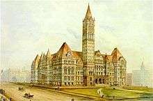
By 1900, the center of business had moved west of the historical Town of York site. A new downtown to the west of Yonge and King Streets was built. The City of Toronto moved into a new Old City Hall, built at the head of Bay Street at Queen Street. Much of this new downtown was destroyed in the Great Toronto Fire of 1904, but it was quickly rebuilt, with new taller buildings. South of downtown, the railways dominated most of the lands. A new viaduct was built to carry the main lines and eliminate the many at-level crossings. A single Union Station was built to replace the several railway stations of the rail lines. It sat empty for a while over disagreements between government and the rail companies.
The Don River has an especially deep ravine, cutting off the east of the city at most points north of the lakeshore. This was addressed in October 1918, when the construction of the Prince Edward Viaduct, was finalized, linking Bloor Street on the western side of the ravine with Danforth Avenue on the east. The designer, Edmund Burke, fought long and hard to have a lower deck added to the bridge for trains, a cost the city was not willing to provide for. Nevertheless, he finally got his way, and thereby saved the city millions of dollars when the Toronto Transit Commission (TTC) subway started using the deck in 1966.
Entrepreneurship was exemplified by the career of John Northway (1848–1926). Beginning as a tailor in a small town, he moved to Toronto and soon developed a chain of department stores. His innovations in the sewing and marketing of ladies' wear enabled the emergence of a Canadian ladies' garment industry. Northway pioneered modern business methods and accounting methods. He innovated as well in labour relations, as a pioneer in sickness and accident compensation and profit-sharing schemes. A millionaire by 1910, he played a leading role in Toronto's civic life.[33][34]
In 1923, two researchers at the University of Toronto, J.J.R. Macleod (1876–1935) and Frederick Banting (1891–1941), shared the Nobel Prize in Medicine for their 1921 discovery of insulin, putting Toronto on the world map of advanced science.[35][36]
From 1926 to 1936, Toronto lawyer, financier, and practical joker Charles Vance Millar created the Great Stork Derby, a contest in which women had to give birth to the most babies within that ten-year-period, which was after his death, in order to qualify for an unusual bequest in a will for a residue of his significant estate.

1939–1970
During World War II, Toronto became a major centre for Canada's military. The Exhibition Grounds were taken over for military training and deployment. The Island Airport was taken over for training of the Norwegian Air Force and the Royal Canadian Air Force. Civilian manufacturing companies, such as Inglis, were converted to war-time production of armaments. At Malton Airport and Downsview Airport, new aviation factories built many fighters and bombers to be used in Europe.
After World War II, a continuous influx of newcomers from Atlantic Canada and large numbers of immigrants from around the world contributed to the steady growth of Toronto. The large numbers of new Canadians helped Toronto's population swell to over one million by 1951, and double again to over two million, by 1971.[37] The demographics of Toronto changed as a result also, as many immigrants were from countries other than Great Britain. The ethnic diversity grew and saw the development of enclaves such as Little Italy, Little Portugal and two new Chinatowns. In 1967, the first "Caribana" festival was held celebrating the culture of the West Indies.[38]
In 1954, Hurricane Hazel swept through Toronto, causing significant flooding; 81 people were killed. As a result, building on floodplains was banned, new flood control works such as dams and flood channels were built, and the lands of floodplains were cleared of buildings, conserved as park lands and conservation areas.

The provincial government created the Municipality of Metropolitan Toronto, a regional government that incorporated numerous local municipalities in 1954. The Metro Toronto government took over the construction and maintenance of region-wide infrastructure, building water treatment plants, roads, public transit and expressways, to facilitate the growth of the suburbs.[39]
In 1954, the original stretch of the subway was completed from Union to Eglinton Stations on the Yonge line (later numbered as Line 1). This was followed by the construction of the Bloor-Danforth and University Avenue subways, connecting the core to the suburbs to the east and west. The Metro Government built the Gardiner Expressway and the Don Valley Parkway expressways in the late 1950s and early 1960s, but plans to build a large network of expressways throughout the city died in 1971 with the cancellation of the Spadina Expressway.[40] Metro proceeded to build the Spadina subway line north into North York and extended the Yonge line north into North York.[40]
The new "urban renewal" movement made its influence felt in Toronto. Large areas, deemed "slums", were cleared. This included the areas of Regent Park, Lawrence Heights and Alexandria Park. The streets and small homes were replaced by mega-blocks with limited streets and apartment buildings. The experiment in social housing would improve the number of affordable units available, at the expense of a large increase in the budgets of Metro and Toronto to maintain the buildings. By the 2000s, Toronto would be in serious arrears on maintenance, and in the 2000s, Toronto has started to dismantle the large projects and replace them with designs more resembling regular neighbourhoods.[41]

During the 1960s and 1970s, Toronto's downtown core was rebuilt with new, taller, skyscrapers. A new Toronto City Hall was opened; the Eaton Centre shopping and office complex; four new bank towers were built at the intersection of Bay and King Streets, the "MINT corners" and new towers along University Avenue. This was causing havoc with the city's old television and radio towers which were simply not tall enough to serve the city, so engineers and politicians decided that something had to be built taller than any other building in the city or anything that would probably ever be built. They decided to build a super-tall massive television and radio tower (the CN Tower), which was completed in 1976 on the railway lands south of downtown. Around the downtown core, which had been dominated by railway lands since the 1850s, new land uses were found for the railway lands. The St. Lawrence Neighbourhood project built a new community from old rail lands to the east of Yonge. Along the waterfront, new office and residential towers were built on former industrial lands. The new SkyDome stadium was built in 1989 on rail lands downtown. South of King Street, west of University Avenue, more railway and warehouse lands were converted, seeing the opening of the Metro Toronto Convention Centre, a new CBC English-language headquarters; Roy Thomson Hall concert hall and the Princess of Wales Theatre.[42]
1970–2000
During the 1970s, the population of Toronto continued to grow, and surpassed that of Montreal. In 1971 the populations of the respective Census Metropolitan Areas (CMAs) for Toronto and Montreal stood at 2.7 million and 2.6 million. By 1981 Toronto had surpassed Montreal with a population of 3 million versus 2.8 million for Montreal. Factors for the growth of Toronto over Montreal included strong immigration, increasingly by Asians and people of African descent, the increasing size of the auto industry in Southern Ontario, due to the signing of the Auto Pact with the US in 1965, a calmer political environment (Quebec experienced two referenda on separation during these years, one in 1980 and the other in 1995), and lower personal income taxes than in Quebec.[43]
Toronto had been the junior partner in Canadian business to Montreal historically. This changed as Toronto grew rapidly after World War II. Another factor was the growing nationalist movement in Quebec, particularly with the success of the Parti Québécois in 1976, systematically alienated Anglophone businesses. By 1995, Toronto controlled 48% of Canada's financial assets and 44% of the non-financial corporate assets, compared to 28% and 22% by Montreal.[44]
During this period, three of Canada's largest banks became headquartered in Toronto: the Royal Bank of Canada, the Toronto-Dominion Bank and the Canadian Imperial Bank of Commerce. These along with the Manulife Financial Corporation, Sun Life Financial Inc. and Toronto Stock Exchange form the financial district, the financial heart of Canada. Toronto also became the corporate capital of Canada with the majority of Canadian companies having their head offices there. Notable examples include: George Weston Limited, Onex Corporation, Magna International Inc., Wal-Mart Canada Corporation and Brookfield Asset Management Inc.
Toronto strengthened its position as the cultural centre of English-speaking Canada during these years. The Globe and Mail and the National Post, two of Canada's most important newspapers have their head offices there. The new CBC Canadian Broadcasting Centre was completed in 1993 and became the corporation's control facility for English language broadcasting in Canada. Also in 1993, Ryerson Polytechnical Institute gained full university status and became Ryerson Polytechnic University. Roy Thomson Hall became the home of the Toronto Symphony Orchestra in 1982. This along with the newly constructed Princess of Wales Theatre and the venerable Royal Alexandra Theatre now form the heart of the theatre district. Cultural institutions including the Art Gallery of Ontario and the Royal Ontario Museum have had their buildings renovated. The Four Seasons Centre became the new home of the Canadian Opera Company and National Ballet of Canada when completed in 2006. The Toronto Film Festival, established in 1976, has become after Cannes, the most important in the world and now sports a new headquarters, the TIFF Bell Lightbox, opened in 2010. Film production has received a boost with the newly completed, Pinewood Toronto Studios, in the east end on the waterfront. Toronto has also been home to the Hockey Hall of Fame (1943), since 1961.
The changing high-rise downtown core provided visual evidence of growth. New skyscrapers included, the Royal Trust Tower, 1969, First Canadian Place, 1975, the CN Tower, 1975, Royal Bank Plaza, South Tower, 1977, the First Bank Tower, 1979, Scotia Plaza, 1988, the Sky Dome, 1989, the BCE Place–Canada Trust Tower, 1990 and the Bay Wellington Tower, 1990. New skyscrapers include: One King Street West, 2005, West 1, 2005, Harbourview Estates 2, 2005, Residences of College Park 1, Toronto, 2006, Quantum 2 (Minto Midtown), 2008, the Bay Adelaide Centre West, 2009, the RBC Centre, 2009, Success, 2009 and Montage, 2009. Canada's largest theme park, Canada's Wonderland opened in 1981.
The loss of many of the old buildings in the downtown saw a new interest among Toronto's citizens to preserve heritage buildings and the City of Toronto began designating buildings to prevent their demolition. The Toronto City Council in the 1970s was dominated by reformers such as David Crombie and John Sewell; opposed to the pace and destructive aspects of Toronto's sudden growth.[45] A by-law was put into place temporarily halting skyscraper construction while land use controls and the official plan was updated.[46]
In the 1990s, Toronto was affected by the country-wide recession. As well, the senior-level governments of Canada and Ontario downloaded the delivery of services. The Ontario government transferred a section of the Queen Elizabeth Way to the Metro Gardiner Expressway, cancelled the Eglinton subway line and trimmed transit, housing and welfare subsidies. The Canadian government formed independent agencies to manage the Toronto International Airport and the Toronto Harbour; the latter particular controversial to Toronto as Toronto City Council wanted to take over the harbour as part of waterfront revitalization efforts. As well, the Canadian government eliminated its public housing programs. These changes would lead to budget crises for the Toronto government of the 2000s.
In 1998, the six municipalities comprising Metropolitan Toronto – East York, Etobicoke, North York, Scarborough, York, and the old City of Toronto – and its regional government were amalgamated into a single City of Toronto (colloquially dubbed the "megacity") by an act of the provincial government. This was despite a municipal referendum in 1997 that was overwhelmingly against amalgamation. Subsequently, Mel Lastman defeated Barbara Hall to become the first elected mayor of the megacity.[47][48]
In January 1999, a series of snowstorms brought severe snow accumulation. Snow clearing crews working around the clock could not keep up with the continuous accumulation, which reached second floor windows. So many of the city's roadways became impassable for residents and Emergency Medical Service vehicles alike that the then Federal Minister of Defence, Art Eggleton, ordered in a detachment of Canadian Armed Forces to patrol the streets to help clear the snow. This was considered an embarrassment by many in Toronto. In much of the remainder of Canada, Toronto became the butt of jokes and even scorn over the army being called in.[49]
21st century
In 2001, Toronto finished second to Beijing in voting by the International Olympic Committee for the host city of the 2008 Summer Olympics.
In 2002, Toronto hosted World Youth Day 2002 and a visit by Pope John Paul II. The municipal government's two largest unions, Locals 79 and 416 of the Canadian Union of Public Employees, went on strike several weeks before the scheduled event, meaning that certain basic services, such as day care and parks programs, were not available. Since city workers also pick up garbage and recycling, city parks became piled high with rubbish – some parks were designated official dump sites for the duration of the strike, while others were used illegally. The situation was resolved when the Ontario government tabled back-to-work legislation to end the strike, and the city was back to normal before the start of World Youth Day.
In early 2003, Toronto was affected by the SARS epidemic. Although the disease was primarily confined to hospitals and health-care workers, tourism in Toronto suffered significantly because of media reports. To help recover the losses the city suffered in industries and tourism, the city held the SARS Benefit Concert (colloquially termed SARSStock), which attracted 450,000 people in late July, making it one of the ten largest concerts in history. Two weeks later, the city was also affected by the 2003 North America blackout. In the resulting chaos, the city ground to a halt, with people taking to the streets to party and talk to their neighbours. Power was not restored for more than 12 hours; in some isolated pockets, not for up to three days.
In the November 2003 municipal election, David Miller was elected to replace Mel Lastman as mayor, after running a successful campaign which included a promise to cancel the proposed fixed link to Toronto Island Airport.
According to a 2004 United Nations report, Toronto has the second-highest proportion of immigrants in the world, after Miami, Florida. Almost half of Toronto's residents were born outside Canada.[50] The resulting cultural diversity is reflected in the numerous ethnic neighbourhoods of the city. The proliferation of shops and restaurants derived from cultures around the world makes the city one of the most exciting places in the world to visit. Moreover, the relative tranquility that mediates between such diverse populations is a testament to the perceived tolerant character of Canadian society.
Toronto hosted the G-20 summit on June 26–27, 2010, but it was not without protests. The protests were met with one of the most expensive temporary security operations seen in Canada and resulted in the largest mass arrests in Canadian history.[51] Later that year, the controversial councillor Rob Ford was elected mayor. His support was based on voters in the former suburbs, highlighting a political schism between the suburbs and the core over spending and services at City Hall. His four-year term was marked by much controversy at City Hall and several drug scandals, leading to City Council suspending his powers and his entry into drug rehab.
Favourable economic conditions and a high demand for housing spurred a condo boom in Toronto, with tens of thousands of upscale apartments constructed throughout the city.[52]
On July 8, 2013, severe flash flooding hit Toronto after an afternoon of slow-moving, intense thunderstorms. Toronto Hydro estimated that 450,000 people were without power after the storm and Toronto Pearson International Airport reported that 126 mm (5 in) of rain had fallen over five hours, more than during Hurricane Hazel.[53] As of August 14, the storm had cost insurers over $850 million in damages,[54] making it Ontario's most costly natural disaster[55] unadjusted for inflation or other considerations.[56] From December 20 to 23, 2013, another costly disaster struck Toronto, this time, an ice storm.
Toronto hosted WorldPride in 2014. Also, in 2014, the municipal election saw the election of John Tory as mayor. He defeated incumbent Rob Ford's brother Doug and former NDP MP Olivia Chow. Rob Ford, who was battling cancer prior to the election, decided not to run as mayor and stood aside so that his brother Doug could run in his place. Rob Ford ran for his old job as councillor in Ward 2 in north-central Etobicoke and was re-elected. Over 980,000 votes were cast after a record voter turnout of 60 percent.[57]
In 2015, Toronto hosted the Pan Am Games and the Parapan American Games.
See also
| Wikimedia Commons has media related to History of Toronto. |
- History of Ontario
- List of oldest buildings and structures in Toronto
- List of historic places in Toronto
- Mantle Site, Wendat (Huron) Ancestral Village, a major First Nations archaeological site in Stouffville, Ontario
References
- Hounsom, Eric Wilfrid (1970). Toronto in 1810. Toronto: Ryerson Press. ISBN 0-7700-0311-7.
- Levine, Allan (2014). Toronto: A Biography. Douglas and McIntyre. ISBN 978-1-77100-022-2.
- McGowan, Mark G. (1999). The Waning of the Green: Catholics, the Irish, and Identity in Toronto, 1887–1922.
- McHugh, Patricia (1989). Toronto Architecture: A City Guide. Toronto: McClelland & Stewart Inc. ISBN 077105520X.
- Shapiro, Linda (1978). Yesterday's Toronto: 1870–1910. Toronto: Coles Publishing. ISBN 0-7740-2678-2.
- Smyth, William J (2015). Toronto, the Belfast of Canada : the Orange Order and the shaping of municipal culture. University of Toronto Press. ISBN 9781442614680.
- Notes
- ↑ Hounsom 1970, pp. xiv-xv.
- ↑ Andrew-Gee, Eric (June 2, 2015). "Toronto street signs a reminder of First Nations heritage | Toronto Star". Thestar.com. Retrieved October 31, 2016.
- ↑ See R. F. Williamson, ed., Toronto: An Illustrated History of its First 12,000 Years (Toronto: James Lorimer, 2008), ch. 2, with reference to the Mantle Site
- ↑ The Ojibwa-Iroquois War: The War the Five Nations Did Not Win. Leroy V. Eid. Ethnohistory, Vol. 26, No. 4 (Autumn, 1979), Duke University Press,pp. 297-324
- ↑ Schmalz, Peter S., The Ojibwa of Southern Ontario. University of Toronto Press. ISBN 0-8020-2736-9. pp 21-22
- ↑ Levine 2014, p. 11.
- ↑ Levine 2014, p. 13.
- ↑ Levine 2014, pp. 14–15.
- ↑ Levine 2014, p. 15.
- 1 2 Levine 2014, p. 25.
- ↑ Levine 2014, p. 23.
- ↑ Levine 2014, pp. 23–24.
- ↑ Levine 2014, p. 26.
- 1 2 Levine 2014, p. 27.
- ↑ Levine 2014, p. 28.
- ↑ McHugh 1989, p. 24.
- ↑ Firth, Edith G., ed. (1966). The Town of York: 1815–1834; A Further Collection of Documents of Early Toronto. University of Toronto Press. pp. 297–298.
- ↑ Patriot. August 1, 1834. Missing or empty
|title=(help) - ↑ Shapiro 1978, p. 5.
- ↑ "Toronto's Historical Plaques". Irish Immigrants and the Fever Sheds 1847. Retrieved January 21, 2012.
- ↑ Levine 2014, pp. 59–85.
- 1 2 "Toronto's First Union Station". Toronto Railway Historical Association. Retrieved November 16, 2015.
- ↑ R. D. Gidney, and W. P. J. Millar, "The Reorientation of Medical Education in Late Nineteenth-Century Ontario: The Proprietary Medical Schools and the Founding of the Faculty of Medicine at the University of Toronto", Journal of the History of Medicine & Allied Sciences, Jan 1994, Vol. 49 Issue 1, pp 52-78
- ↑ Bill Rawling, "Technology and Innovation in the Toronto Police Force, 1875–1925", Ontario History, Mar 1988, Vol. 80 Issue 1, pp 53-71
- ↑ Murray Nicholson, "The Growth of Roman Catholic Institutions in the Archdiocese of Toronto, 1841-90", in Terrence Murphy and Gerald Stortz, eds, Creed and Culture: The Place of English-Speaking Catholics in Canadian Society, 1750 – 1930 (1993) pp 152-170
- ↑ Paula Maurutto, Governing Charities: Church and State in Toronto: Catholic Archdioces, 1850–1950 (McGill-Queen's University Press, 2001)
- ↑ Mark G. McGowan, Michael Power: The Struggle to Build the Catholic Church on the Canadian Frontier (2007)
- ↑ Smyth 2015, p. 3.
- ↑ see Orange Canada
- ↑ McGowan 1999.
- ↑ Lindstrom-Best, Varpu (1979). The Finnish immigrant community of Toronto, 1887–1913. Toronto: Multicultural History Society of Ontario.
- ↑ John Powell (2009). Encyclopedia of North American Immigration. Infobase Publishing. pp. 194–95.
- ↑ G. Alan Wilson, "John Northway's Career: An Approach to Ontario's History", Ontario History, March 1964, Vol. 56 Issue 1, pp 37-44
- ↑ Wilson, Alan (2005). "Northway, John". In Cook, Ramsay; Bélanger, Réal. Dictionary of Canadian Biography. XV (1921–1930) (online ed.). University of Toronto Press.
- ↑ Bliss, Michael (August 13, 2015). "Sir Frederick Grant Banting". The Canadian Encyclopedia (online ed.). Historica Canada.
- ↑ J. M. Fenster, "The Conquest of Diabetes", American Heritage of Invention & Technology, Jan 1999, Vol. 14 Issue 3, pp 48-55
- ↑ Careless, J.M.S. (July 27, 2015). "Toronto". The Canadian Encyclopedia (online ed.). Historica Canada.
- ↑ Levine 2014, p. 82.
- ↑ Albert Rose, Governing metropolitan Toronto: A social and political analysis, 1953–1971 (1972.)
- 1 2 Levine 2014, p. 246.
- ↑ Kevin Brushett, "Blots on the Face of the City: The Politics of Slum Housing and Urban Renewal in Toronto, 1940–1970" (PhD thesis, Queen's U., 2001) online
- ↑ John Sewell, The shape of the city: Toronto struggles with modern planning (U of Toronto Press, 1993)
- ↑ Harold Troper, "Becoming an immigrant city: A history of immigration into Toronto since the Second World War" by Paul Anisef and Michael Lanphier, edfs. The world in a city (2003) pp: 19-62.
- ↑ John N. H. Britton, Canada and the global economy: the geography of structural and technological change (1996) p 296
- ↑ Levine 2014, p. 247.
- ↑ Levine 2014, p. 248.
- ↑ W. Les Kelman, "Municipal Mergers: The New City of Toronto Experience." Institute of Transportation Engineers. ITE Journal 70.5 (2000): 43+ online
- ↑ Stefan Kipfer and Roger Keil. "Toronto Inc? Planning the competitive city in the new Toronto." Antipode 34#.2 (2002) pp: 227-264.
- ↑ Fassnacht, S. R., F. Yusuf, and N. Kouwen. "Paralysing January 1999 Snowstorms Produced Minimal Streamflow for Southern Ontario." Canadian Water Resources Journal 29.1 (2004): 1-12. online
- ↑ "Toronto second city in the world for migrants". CBC News. July 16, 2004.
- ↑ "G20-related mass arrests unique in Canadian history". The Globe and Mail. June 28, 2010.
- ↑ Austen, Ian (July 2, 2013). "A Dizzying Condo Market in Toronto". The New York Times. Retrieved January 21, 2014.
- ↑ "Environment Canada answers the question: Where was Toronto's severe thunderstorm warning?". Global Toronto. July 9, 2013. Retrieved July 18, 2013.
- ↑ "Toronto's July storm cost insurers $850M". CBC News. August 14, 2013. Retrieved September 6, 2013.
- ↑ "Toronto's July flood listed as Ontario's most costly natural disaster". Toronto Star. August 14, 2013. Retrieved September 6, 2013.
- ↑ Peter Bowyer (2004). "Recovery — Evaluation". Canadian Hurricane Centre. Retrieved June 17, 2009.
- ↑ McLean, Jesse (October 28, 2014). "Voter turnout rocketed in Toronto, tepid around GTA". Toronto Star. Retrieved April 4, 2015.
Further reading
- Anisef, Paul. and C. Michael Lanphier, eds. (2003). The World in a City. University of Toronto Press., history and impact of immigration to Toronto
- Careless, J. M. S. Brown of the Globe (2 vols, Toronto, 1959–63) online, leading editor of the mid-19th century
- Desfor, Gene and Roger Keil, eds. Nature and the City: Making Environmental Policy in Toronto and Los Angeles (2004)
- Freeman, Victoria Jane. "'Toronto has no history!' Indigeneity, settler colonialism, and historical memory in Canada's largest city." (PhD Dissertation, University of Toronto, 1970)
- Frisken, Frances. The Public Metropolis: The Political Dynamics of Urban Expansion in the Toronto Region, 1924–2003 (2007)
- Hayes, Derek (2009). Historical Atlas of Toronto.
- Jenkins, William. Between Raid and Rebellion: The Irish in Buffalo and Toronto, 1867–1916 (McGill-Queens University Press, 2013) 511 pp.
- Jones, Donald. Historical Toronto (Toronto Star, 1993)
- MacFarlane, David (2008). Toronto: A City Becoming. pp. 304pp.
- Maurutto, Paula. Governing Charities: Church and State in Toronto's Catholic Archdiocese, 1850–1950 (2003)
- Rawlings-Way, Charles; Karneef, Natalie (2007). Toronto.
- Rose, Albert. Governing metropolitan Toronto: A social and political analysis, 1953–1971 (1972)
- Russell, Victor L. ed. Forging a Consensus: Historical Essays on Toronto (1984)
- City staff (2015). Bibliography of Toronto History (PDF) (pdf). City of Toronto.
- Robertson, J. Ross (John Ross) (1894). Landmarks of Toronto. Toronto: J. Ross Robertson.
External links
- Toronto: A Place of Meeting from the Toronto Public Library's virtual gallery
- The History of the Battle of Toronto by William Lyon MacKenzie, 1839 from the Ontario Time Machine
- Historicist articles on Toronto History by Torontoist.ca
- Toronto Boom Town, a 1951 National Film Board of Canada documentary covering the first half of the 20th century
- Toronto Past, a blog devoted to links to Toronto history stories and resources
| Features | |||||||
|---|---|---|---|---|---|---|---|
| History |
| ||||||
| Geography | |||||||
| Economy | |||||||
| Politics |
| ||||||
| Public services | |||||||
| Education | |||||||
| Culture |
| ||||||
| Transportation |
| ||||||
| |||||||
| Year list (Timeline) | |
|---|---|
| Topics | |
| Provinces & territories | |
| Cities | |
| Research | |
| |