Santa Maria, California
| Santa Maria | |
|---|---|
| Charter city[1] | |
| Nickname(s): BBQ Capital of California | |
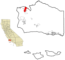 Location in Santa Barbara County and the state of California | |
 Santa Maria Location in California | |
| Coordinates: 34°57′5″N 120°26′0″W / 34.95139°N 120.43333°WCoordinates: 34°57′5″N 120°26′0″W / 34.95139°N 120.43333°W | |
| Country |
|
| State |
|
| County |
|
| Metro | Santa Maria-Santa Barbara |
| Founded | 1874 |
| Incorporated | September 12, 1905[2] |
| Chartered | December 2000[1] |
| Government | |
| • Type | Council-manager[1] |
| • Mayor | Alice Patino[3] |
| • State Senator | Hannah-Beth Jackson (D)[4] |
| • Assemblymember | Jordan Cunningham (R)[4] |
| • U. S. Rep. | Lois Capps (D)[5] |
| Area[6] | |
| • City | 23.395 sq mi (60.592 km2) |
| • Land | 22.756 sq mi (58.937 km2) |
| • Water | 0.639 sq mi (1.655 km2) 2.73% |
| • Metro | 2,735.09 sq mi (7,083.9 km2) |
| Elevation[7] | 217 ft (66 m) |
| Population (April 1, 2010)[8] | |
| • City | 99,553 |
| • Estimate (2014)[9] | 103,410 |
| • Density | 4,300/sq mi (1,600/km2) |
| • Metro[10] | 423,895 |
| • Metro density | 150/sq mi (60/km2) |
| Time zone | Pacific (UTC-8) |
| • Summer (DST) | PDT (UTC-7) |
| ZIP codes | 93454–93458 |
| Area code | 805 |
| FIPS code | 06-69196 |
| GNIS feature IDs | 1652791, 2411824 |
| Website |
www |
Santa Maria is a city near the Southern California coast in Santa Barbara County. It is approximately 120 miles (190 km) northwest of Los Angeles (city limits). Its estimated 2014 population was 103,410,[9] making it the most populous city in the county and the Santa Maria-Santa Barbara, CA Metro Area. The city is notable for its wine industry and Santa Maria-style barbecue. Sunset magazine called Santa Maria "The West's Best BBQ Town".[11]
History
The Santa Maria Valley, stretching from the Santa Lucia Mountains toward the Pacific Ocean, was the homeland of the Chumash people for several thousand years. The Native Americans made their homes on the slopes of the surrounding hills among the oaks, on the banks of the Santa Maria River among the sycamores, and along the coast. They had unique plank-built boats, called Tomol, which they used for ocean fishing.
In 1769, the Portolá Expedition passed through the Santa Maria Valley during the first Spanish land exploration up the coast of Las Californias Province. Mission San Luis Obispo de Tolosa was established just north of the valley in 1772, and Mission La Purísima Concepción was established near present-day Lompoc in 1787. Rather than rich soil, white settlers were attracted here by the possibility of free land. In 1821, after the Mexican War of Independence, the mission lands in Santa Maria Valley were made available for private ownership under a Mexican land grant called Rancho Punta de Laguna. At the end of the Mexican War in 1848, California was ceded to the United States.
In the late 19th century, after California gained statehood in 1850, the area's rich soil attracted farmers and other settlers. By the end of the century, the Santa Maria River Valley had become one of the most productive agricultural areas in the state. Agriculture is still a key component of the economy for the city and the entire region.[12]
Between 1869 and 1874, four of the valley's settlers, Rudolph Cook, John Thornburg, Isaac Fesler (for whom Fesler Jr. High School is named), and Isaac Miller (for whom Miller Elementary School is named), built their homes near each other at the present corners on Broadway and Main Street. The townsite was recorded in Santa Barbara in 1875. The new town was named Grangerville, then changed to Central City. It became Santa Maria on February 18, 1885, since mail was often being sent by mistake to Central City, Colorado. Santa Maria was chosen from the name Juan Pacifico Ontiveros had given to his property 25 years earlier. Streets named after the four settlers now form a 6 block square centered at Broadway and Main Street, the center of town.
Oil exploration began in 1888, leading to large-scale discoveries at the turn of the 20th century. In 1902, Union Oil discovered the large Orcutt Oil Field in the Solomon Hills south of town, and a number of smaller companies also began pumping oil. Two years later, Union Oil had 22 wells in production. Other significant discoveries followed, including the Lompoc Oil Field in 1903 and the Cat Canyon field in 1908. Over the next 80 years more large oil fields were found, and thousands of oil wells drilled and put into production. Oil development intensified in 1930s, with the discovery of the Santa Maria Valley Oil Field in 1934,[13] right underneath the southern and western parts of the city of Santa Maria, which spurred the city's growth even further. By 1957 there were 1,775 oil wells in operation in the Santa Maria Valley, producing more than $640 million worth of oil.
Geography
Santa Maria is located at 34°57′5″N 120°26′0″W / 34.95139°N 120.43333°W (34.951377, -120.433373).[14]
According to the United States Census Bureau, the city has a total area of 22.4 square miles (58 km2), of which, 22.8 square miles (59 km2) of it is land and 0.6 square miles (1.6 km2) of it (2.73%) is water.
Santa Maria is situated north of the unincorporated township of Orcutt, California, and south of the Santa Maria River (which serves as the line between Santa Barbara County and San Luis Obispo County). The valley is bordered on the west by the Pacific Ocean and to the east by the San Rafael Mountains and the Los Padres National Forest. The city of Guadalupe, California is approximately 9 miles (14 km) to the west of Santa Maria.
Climate
Santa Maria experiences a cool Mediterranean climate (Köppen climate classification Csb) typical of coastal areas of California north of Point Conception. The climate is mostly sunny, refreshed by the ocean breeze. Fog is common. Snow in the lowest parts of the city is virtually unknown, with the last brief flurry recorded in January 1949. The only recorded earlier snowfall was in January 1882. Rainfall averages 14 inches (360 mm) annually.
| Climate data for Santa Maria Public Airport, California (1981–2010, extremes 1948–present) | |||||||||||||
|---|---|---|---|---|---|---|---|---|---|---|---|---|---|
| Month | Jan | Feb | Mar | Apr | May | Jun | Jul | Aug | Sep | Oct | Nov | Dec | Year |
| Record high °F (°C) | 89 (32) |
89 (32) |
95 (35) |
103 (39) |
101 (38) |
100 (38) |
98 (37) |
99 (37) |
106 (41) |
108 (42) |
96 (36) |
90 (32) |
108 (42) |
| Mean maximum °F (°C) | 77.2 (25.1) |
79.1 (26.2) |
79.8 (26.6) |
85.4 (29.7) |
84.1 (28.9) |
84.1 (28.9) |
84.9 (29.4) |
84.9 (29.4) |
90.1 (32.3) |
91.8 (33.2) |
84.4 (29.1) |
76.2 (24.6) |
95.8 (35.4) |
| Average high °F (°C) | 63.4 (17.4) |
64.0 (17.8) |
65.1 (18.4) |
67.2 (19.6) |
68.5 (20.3) |
70.4 (21.3) |
72.6 (22.6) |
73.1 (22.8) |
73.7 (23.2) |
73.0 (22.8) |
68.5 (20.3) |
63.4 (17.4) |
68.6 (20.3) |
| Average low °F (°C) | 39.5 (4.2) |
41.7 (5.4) |
43.0 (6.1) |
44.0 (6.7) |
47.4 (8.6) |
50.6 (10.3) |
53.8 (12.1) |
54.2 (12.3) |
52.7 (11.5) |
48.7 (9.3) |
43.0 (6.1) |
39.1 (3.9) |
46.5 (8.1) |
| Mean minimum °F (°C) | 29.8 (−1.2) |
31.3 (−0.4) |
34.2 (1.2) |
35.5 (1.9) |
39.7 (4.3) |
43.8 (6.6) |
48.6 (9.2) |
48.7 (9.3) |
45.9 (7.7) |
40.1 (4.5) |
33.1 (0.6) |
28.7 (−1.8) |
27.1 (−2.7) |
| Record low °F (°C) | 20 (−7) |
22 (−6) |
24 (−4) |
28 (−2) |
27 (−3) |
35 (2) |
41 (5) |
40 (4) |
32 (0) |
26 (−3) |
21 (−6) |
20 (−7) |
20 (−7) |
| Average precipitation inches (mm) | 2.75 (69.9) |
2.99 (75.9) |
2.64 (67.1) |
0.98 (24.9) |
0.31 (7.9) |
0.04 (1) |
0.03 (0.8) |
0.02 (0.5) |
0.14 (3.6) |
0.60 (15.2) |
1.33 (33.8) |
2.12 (53.8) |
13.95 (354.3) |
| Average precipitation days (≥ 0.01 in) | 7.7 | 8.7 | 8.1 | 4.3 | 1.6 | 0.6 | 0.4 | 0.5 | 1.1 | 3.0 | 5.2 | 6.9 | 48.1 |
| Average relative humidity (%) | 65.4 | 72.7 | 75.7 | 75.6 | 78.9 | 79.3 | 81.2 | 79.9 | 80.5 | 74.7 | 71.3 | 70.8 | 75.5 |
| Source: NOAA (relative humidity 1961–1990)[15][16][17] | |||||||||||||
Economy
Agriculture plays an important role in the city's economy. The Santa Maria area is home to an increasing number of vineyards, wineries and winemakers and is centrally located to both the Santa Ynez and Foxen Canyon areas of Santa Barbara County's wine country, and San Luis Obispo County's Edna Valley-Arroyo Grande wine country.
The agricultural areas surrounding the city are some of the most productive in California, with primary crops including strawberries, wine grapes, celery, lettuce, peas, squash, cauliflower, spinach, broccoli and beans. Many cattle ranchers also call the Santa Maria Valley home.
In recent years, other industries have been being added to the city's agricultural and retail mix, including: aerospace; communications; high-tech research and development; energy production; military operations; and manufacturing. The petroleum industry has had a large presence in the area since oil was first discovered at the Orcutt Oil Field in 1902. By 1957 there were 1,775 oil wells in operation in the Santa Maria Valley, producing more than $640 million worth of oil.[12]
Top employers
According to the City's 2013 Comprehensive Annual Financial Report,[18] and updated City of Santa Maria employee figures reported in the 2014-2016 City Budget,[19] the top employers in the city are:
| # | Employer | # of Employees |
|---|---|---|
| 1 | Vandenberg Air Force Base | 6,623 |
| 2 | Santa Maria-Bonita School District | 1,835 |
| 3 | Marian Regional Medical Center | 1,480 |
| 4 | Allan Hancock College | 1,150 |
| 5 | C&D Zodiac Aerospace | 1,100 |
| 6 | Santa Maria Joint Union High School District | 722 |
| 7 | City of Santa Maria | 559 |
| 8 | Betteravia Farms | 450 |
| 9 | VTC Enterprises | 366 |
| 10 | Walmart | 300 |
Demographics
| Historical population | |||
|---|---|---|---|
| Census | Pop. | %± | |
| 1910 | 2,260 | — | |
| 1920 | 3,943 | 74.5% | |
| 1930 | 7,057 | 79.0% | |
| 1940 | 8,522 | 20.8% | |
| 1950 | 10,440 | 22.5% | |
| 1960 | 20,027 | 91.8% | |
| 1970 | 32,749 | 63.5% | |
| 1980 | 39,685 | 21.2% | |
| 1990 | 61,284 | 54.4% | |
| 2000 | 77,423 | 26.3% | |
| 2010 | 99,553 | 28.6% | |
| Est. 2015 | 105,093 | [20] | 5.6% |
2010
The 2010 United States Census[22] reported that Santa Maria had a population of 99,553. The population density was 4,255.3 people per square mile (1,643.0/km²). The racial makeup of Santa Maria was 55,983 (56.2%) White, 1,656 (1.7%) African American, 1,818 (1.8%) Native American, 5,054 (5.1%) Asian, 161 (0.2%) Pacific Islander, 29,841 (30.0%) from other races, and 5,040 (5.1%) from two or more races. Hispanic or Latino of any race were 70,114 persons (70.4%).
The Census reported that 98,546 people (99.0% of the population) lived in households, 588 (0.6%) lived in non-institutionalized group quarters, and 419 (0.4%) were institutionalized.
There were 26,908 households, out of which 13,223 (49.1%) had children under the age of 18 living in them, 14,616 (54.3%) were opposite-sex married couples living together, 3,962 (14.7%) had a female householder with no husband present, 1,901 (7.1%) had a male householder with no wife present. There were 1,754 (6.5%) unmarried opposite-sex partnerships, and 190 (0.7%) same-sex married couples or partnerships. 5,079 households (18.9%) were made up of individuals and 2,431 (9.0%) had someone living alone who was 65 years of age or older. The average household size was 3.66. There were 20,479 families (76.1% of all households); the average family size was 4.06.
The population was spread out with 31,302 people (31.4%) under the age of 18, 12,170 people (12.2%) aged 18 to 24, 28,486 people (28.6%) aged 25 to 44, 18,204 people (18.3%) aged 45 to 64, and 9,391 people (9.4%) who were 65 years of age or older. The median age was 28.6 years. For every 100 females there were 102.2 males. For every 100 females age 18 and over, there were 100.7 males.
There were 28,294 housing units at an average density of 1,209.4 per square mile (467.0/km²), of which 13,893 (51.6%) were owner-occupied, and 13,015 (48.4%) were occupied by renters. The homeowner vacancy rate was 1.9%; the rental vacancy rate was 3.8%. 46,463 people (46.7% of the population) lived in owner-occupied housing units and 52,083 people (52.3%) lived in rental housing units.
2000
According to the 2000 census,[23] there were 77,423 people, 22,146 households, and 16,653 families residing in the city. The population density was 4,005.8 people per square mile (1,546.5/km²). There were 22,847 housing units at an average density of 1,182.1 per square mile (456.4/km²). The racial makeup of the city was 58.0% White, 1.9% African American, 1.8% Native American, 4.7% Asian, 0.18% Pacific Islander, 28.02% from other races, and 5.36% from two or more races. Hispanic or Latino of any race were 47.3% of the population.
There were 22,146 households out of which 42% had children under the age of 18 living with them, 56.4% were married couples living together, 13.3% had a female householder with no husband present, and 24.8% were non-families. 20.0% of all households were made up of individuals and 9.3% had someone living alone who was 65 years of age or older. The average household size was 3.40 and the average family size was 3.85.
In the city the population was spread out with 31.6% under the age of 18, 11.6% from 18 to 24, 29.5% from 25 to 44, 15.9% from 45 to 64, and 11.3% who were 65 years of age or older. The median age was 29 years. For every 100 females there were 103.2 males. For every 100 females age 18 and over, there were 101.6 males.
The median income for a household in the city was $51,739, and the median income for a family was $48,233. Males had a median income of $28,700 versus $22,364 for females. The per capita income for the city was $13,780. About 15.5% of families and 19.7% of the population were below the poverty line, including 26.5% of those under age 18 and 7.7% of those age 65 or over.
Law and government
Courts
Santa Maria is home to one of three official Superior Court locations in Santa Barbara County, with the other courthouse located in Santa Barbara. From 2003-2005, the Superior Court handled a felony complaint against Michael Jackson (see Michael Jackson: 2005 trial) which reached a not guilty verdict on June 13, 2005. The District Attorney chose to present the trial in Santa Maria due to its close proximity from Neverland Ranch where the alleged incident took place.
Politics
Santa Maria is split down the middle of the political spectrum, in contrast to Santa Barbara, which tends to be more liberal. Due in part to this political division, plus irrigation and water-supply issues, many attempts have been made to divide the county, the northern portion from Point Conception upwards to become Mission County. Thus far the movement has been unsuccessful.
Law enforcement
As the primary law enforcement agency for the City of Santa Maria, the Santa Maria Police Department handles approximately 130,000 calls for service each year. The Santa Barbara County Sheriff's Office also operates within the city in addition to the Santa Maria Park Officers who consist of 6 sworn officers who derive their authority under CA Penal code section 831.31(b). The SMPD is administratively divided into the three divisions, Administration, Operations, and Support, and has 111 sworn officers and 49 full-time support personnel.[24]
Transportation

Roads
U.S. Route 101 runs through the middle of the Santa Maria Valley and is the main freeway connecting many west coast cities. It has been improved to freeway status (meaning all at-grade intersections have been eliminated) within the city of Santa Maria itself. There was recently a widening project that expanded the freeway from four to six lanes between Santa Maria Way and the Route 135 overcrossing. The $32 million project was completed in late 2008 / early 2009.
State Route 1 runs around the western edge of the city and connects it to nearby Vandenberg Air Force Base near Lompoc. The section of 101 in the city is a freeway, and a small part of a nearby section of Highway 1 that runs between the city and the base is also a freeway, but the two freeway segments do not directly connect to each other.
State Route 135 is considered to be the major artery through the city. It comes from Los Alamos, a town to the south of Santa Maria, and it enters Orcutt and Santa Maria as an expressway. The expressway runs all the way to Santa Maria Way. Highway 135 then turns into Broadway and runs through the heart of the city and all the way up to the Santa Maria River and U.S. 101.
Rail
The Santa Maria Valley Railroad (SMVRR) is a shortline freight railroad to Guadalupe where the Union Pacific Railroad Interchange point is. Main business includes storage of railroad cars when northern California and southern California storage area are full.
The nearest train station with long-distance Amtrak service is in Guadalupe, to which Amtrak provides bus service from Santa Maria. Amtrak's Pacific Surfliner provides twice daily service in each direction, running to San Luis Obispo to the north and to San Diego via Los Angeles to the south.
Bus
SMAT, Santa Maria Area Transit, is a local bus service provided by both city and county-run lines, it has recently expanded its services during the evening that stretch to 10:15 P.M. The Breeze Bus provides service to Lompoc, Vandenberg Air Force Base, and Santa Maria. RTA Route 10 connects Santa Maria and San Luis Obispo. The Guadalupe Flyer connects Santa Maria and Guadalupe.
Long-distance intercity bus service is provided by Greyhound Lines. The Clean Air Express commuter bus runs between Santa Maria and Goleta as well as a line to Santa Barbara weekdays.
Airlines
The Santa Maria Public Airport is served by two airlines, Allegiant Air and SkyWest Airlines with the latter operating as United Express on behalf of United Airlines. Allegiant Air operates nonstop jet service several days a week to Las Vegas. Skywest operates nonstop flights to Los Angeles (LAX) several times a day with turboprop aircraft via a code sharing agreement with United.
Education
Allan Hancock College
Allan Hancock College is a California public community college located in northern Santa Barbara County. Allan Hancock College was ranked as one of the five best community colleges in California and one of the nation's top 120 community colleges.[25] Approximately 11,500 credit students enroll each semester at one of the college's four locations in Santa Maria, Lompoc, Solvang, or at Vandenberg Air Force Base.[26] The main campus is in Santa Maria, a 105-acre park-like setting that provides students with exceptional teaching and state of the art technology. Allan Hancock College is known for its distinguished athletic programs which have included former head football coaches John Madden and Ernie Zampese, as well as Gunther Cunningham. The college is also home to the Pacific Conservatory of the Performing Arts, one of the state's finest theatre programs.
School Districts
The Santa Maria Joint Union High School District (SMJUHSD) is the oldest high school district in the State of California and runs the 3 primary public high schools in the area, including Santa Maria High School, Pioneer Valley High School,and Ernest Righetti High School. There are also four notable private schools in the valley, St. Joseph High School, St. Marys Catholic School, Valley Christian Academy, and Pacific Christian School Grades K-8th. The Santa Maria-Bonita School District is home to 13,700 students in 15 elementary schools (K-6th grade) and four junior high schools (7th-8th grade). The schools in the Santa Maria-Bonita School District serve students who live within the city limits of Santa Maria, the county area of Tanglewood and the county area just outside Santa Maria heading toward Guadalupe. The SMBSD schools are on a traditional calendar schedule and offer a quality, comprehensive education. The Orcutt Union School District serves students who live in the unincporporated community of Orcutt. The Orcutt Union School District recently added a new school known as Orcutt Academy High School in the 2008-2009 school year. It is located next to Orcutt Junior High School's campus on the old May Grisham campus.
Santa Maria is also home to Santa Barbara Business College, which has been serving the community since 1982.
Culture
Tri-Tip and Santa Maria-style barbecue
Santa Maria is perhaps most notable for an excellent variety of barbecued meat. The tri-tip steak has its roots in Santa Maria. Tri-tip is a cut of beef from the bottom sirloin. It is a small triangular muscle, usually 1.5 to 2.5 lb (680 to 1,130 g) per side of beef. In the United States, this cut was typically used for ground beef or sliced into steaks until the late 1950s, when it became a local specialty in Santa Maria. "Santa Maria-style" barbecue is usually used in reference to the seasoning of tri-tip or other meats (most notably top sirloin, or "top block") when rubbed with salt, pepper, and spices and cooked whole on a rotisserie or grilled over local red oak wood. The side dishes complementing a typical "Santa Maria-style" barbecue generally consist of garlic bread, pinquito beans, and a salad.
Sunset Magazine's August 2013 issue features a 10-page spread on Santa Maria Style BBQ, crowning Santa Maria as "The West's Best BBQ Town".[11]
Wine
Santa Maria, along with the neighboring Lompoc, Los Alamos and Santa Ynez Valleys, combine to create one of the nation's largest wine-producing regions, referred to as the Santa Barbara Wine Country.
The often foggy and windswept Santa Maria Valley is the northern most appellation in Santa Barbara County. The region's first officially approved American Viticultural Area (AVA) enjoys extremely complex soil conditions and diverse microclimates. Chardonnay and Pinot noir are two varietals which especially benefit from the ocean's influence, and are the flagship wines of this appellation.
Santa Maria Valley grapes are also used by wineries throughout Santa Barbara County and at many wineries outside of the county. The Santa Maria Valley name is used on labels from wineries that are based far away from the Santa Barbara County sunshine. The Santa Maria Valley appellation is bounded by the San Rafael Mountains and the Los Padres National Forest to the east, and by the Solomon Hills and the city of Santa Maria to the west.
Theatre
Santa Maria's Allan Hancock College is the home of The Pacific Conservatory of the Performing Arts (PCPA), a highly touted theatrical school and production company. Notable alumni include: Robin Williams, Kathy Bates, Kelly McGillis, Mercedes Ruehl, and Zac Efron.
An additional PCPA theatre is located in Solvang, California in the Santa Ynez Valley.
Film
The Santa Maria Valley has long been a major filming location for Hollywood. Some of the films shot in the valley include:
- Pirates of the Caribbean: At World's End, (2007)
- Pirates of the Caribbean: Dead Man's Chest, (2006)
- Sideways, (2004)
- Hidalgo, (2003)
- Cowboy Up, (2001)
- Rockets Red Glare, (2000)
- The Odd Couple II, (1997)
- Barton Fink, (1991)
- The Rocketeer, (1991)
- The Spirit of St. Louis, (1957)
- Invasion of the Body Snatchers, (1956)
- The Ten Commandments, (1923)
Television
In the Space: 1999 episode "Another Time, Another Place", the "Earth" Alphans, during their period on Earth, have build a small village in the destroyed Santa Maria,[27] discovering that on Earth there was an Atlantis-like civilization.
Radio
- 88.9 KXWB
- 89.7 KCLM operated by Cal Lutheran
- 90.5 KGDP
- 92.9 KTAP
- 95.3 The Beach out of Pismo Beach
- 99.1 KXFM
- 100.3 KRQK, Lompoc.
- 101.7 KGZO
- 102.5 KSNI
Recreation
The Santa Maria Skate Park is located in Fletcher Park. There is also the Paul Nelson Aquatic Center/Abel Maldonado Community Youth Center.
Notable people
Entertainment
- Kathy Bates, actress
- Gary Coleman, actor
- Nino Del Pesco, musician
- Beverlee McKinsey, actress
- Kim Miyori, actress
- Joe Nanini, musician
- Chuck Negron, founding member of Three Dog Night
- Jane Russell, actress
- Aurora Snow, actress
- Chris Lambert, musician
Sports
- Mark Brunell, former NFL football player [28]
- Paco Craig, gridiron football player
- Gunther Cunningham, former head football coach of the Kansas City Chiefs
- Carlos Dias, former Major League Baseball pitcher
- Blaine Johnson, former NHRA Top Fuel driver
- Jim Lonborg, former Major League Baseball player[29]
- John Madden, Hall of Fame NFL football coach and commentator
- Marla Runyan, Marathon Runner
- Bryn Smith, retired Major League Baseball pitcher who played for both Santa Maria High School and Allan Hancock College[30]
- Ozzie Smith, Hall of Fame Major League Baseball player
- Robin Ventura, former Major League Baseball player and current Manager of the Chicago White Sox[31]
- Jimy Williams, Major League Baseball manager[32]
- Ernie Zampese, NFL football coach
- Ken Zampese, NFL football coach
- Carlos Balderas, Olympic Boxer.
- Josh Prenot, Olympic Swimmer and silver Medal recipient.
Politics
Other
- George Allan Hancock, Philanthropist, oil(owned west Los Angeles and the La Brea Tar Pits), railroad and aviation engineer.
- William Kraemer Coblentz, attorney and politician
- James Lamar McElhany, President of the General Conference of Seventh-day Adventists from 1936 to 1950
- Inga Muscio, author and activist
- Owen W. Siler, 15th Commandant of the United States Coast Guard (1974–1978)[34]
- Carol Sklenicka, literary biographer
References
- 1 2 3 "City Profile". City of Santa Maria. Retrieved March 20, 2015.
- ↑ "California Cities by Incorporation Date" (Word). California Association of Local Agency Formation Commissions. Retrieved August 25, 2014.
- ↑ "Mayor & City Council". City of Santa Maria. Retrieved January 7, 2015.
- 1 2 "Statewide Database". UC Regents. Retrieved November 30, 2014.
- ↑ "California's 24th Congressional District - Representatives & District Map". Civic Impulse, LLC. Retrieved September 29, 2014.
- ↑ "2010 Census U.S. Gazetteer Files – Places – California". United States Census Bureau.
- ↑ "Santa Maria". Geographic Names Information System. United States Geological Survey. Retrieved October 11, 2014.
- ↑ "Santa Maria (city) QuickFacts". United States Census Bureau. Retrieved January 28, 2015.
- 1 2 "American FactFinder - Results". United States Census Bureau. Retrieved May 24, 2015.
- ↑ "American FactFinder - Results". United States Census Bureau. Retrieved May 24, 2015.
- 1 2 http://santamariavalleybbq.com/2013/07/25/sunsets-epic-feature-on-santa-maria-bbq/
- 1 2 http://www.ci.santa-maria.ca.us/history.html
- ↑ "2008 Report of the state oil & gas supervisor" (PDF). Department of Oil, Gas, and Geothermal Resources. California Department of Conservation. 2009. Retrieved January 3, 2010. p. 63
- ↑ "US Gazetteer files: 2010, 2000, and 1990". United States Census Bureau. 2011-02-12. Retrieved 2011-04-23.
- ↑ "NOWData - NOAA Online Weather Data". National Oceanic and Atmospheric Administration. Retrieved September 27, 2015.
- ↑ "CA Santa Maria Public AP". National Oceanic and Atmospheric Administration. Retrieved September 27, 2015.
- ↑ "WMO Climate Normals for Santa Maria/Public, CA 1961–1990". National Oceanic and Atmospheric Administration. Retrieved September 27, 2015.
- ↑ City of Santa Maria CAFR
- ↑
- ↑ "Annual Estimates of the Resident Population for Incorporated Places: April 1, 2010 to July 1, 2015". Retrieved July 2, 2016.
- ↑ "Census of Population and Housing". Census.gov. Retrieved June 4, 2015.
- ↑ "2010 Census Interactive Population Search: CA - Santa Maria city". U.S. Census Bureau. Retrieved July 12, 2014.
- ↑ "American FactFinder". United States Census Bureau. Retrieved 2008-01-31.
- ↑ http://www.ci.santa-maria.ca.us/40451.html ci.santa-maria.ca
- ↑ http://santamariachambernews.com/2011/05/hancock-named-one-of-nations-top-120-community-colleges/
- ↑ http://www.wolframalpha.com/entities/university_total_enrollment/how_many_students_are_there_in_allan_hancock_college/nj/2x/qj/
- ↑ Space: 1999" episode "Another Time, Another Place".
- ↑ "Mark Allen Brunell". databaseFootball.com. Retrieved December 27, 2012.
- ↑ "Jim Lonborg Stats". Baseball Almanac. Retrieved December 27, 2012.
- ↑ "Bryn Smith Stats". Baseball Almanac. Retrieved December 27, 2012.
- ↑ "Robin Ventura Stats". Baseball Almanac. Retrieved December 27, 2012.
- ↑ "Jimy Williams Stats". Baseball Almanac. Retrieved December 27, 2012.
- ↑ "abel maldonado's voting records". Project Vote Smart. Retrieved December 27, 2012.
- ↑ "obituary: adm. owen w. siler". US Department of Homeland Security. Retrieved December 27, 2012.
External links
| Wikimedia Commons has media related to Santa Maria, California. |
| Wikivoyage has a travel guide for Santa Maria. |
- Official website
- City-Data.com profile
- ePodunk profile
- Movies and television shows filmed in Santa Maria
Municipalities and communities of Santa Barbara County, California, United States | ||
|---|---|---|
| Cities | 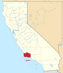 | |
| CDPs | ||
| Unincorporated communities | ||
| Indian reservation | ||
| Ghost towns | ||
| Counties |  | |
|---|---|---|
| Cities and towns 100k-250k | ||
| Cities and towns 25k-100k | ||
| Cities and towns 10k-25k | ||
| Sub-regions | ||
Counties in italics sometimes included in the definition of the Central Coast | ||
| |
^* Mayor selected from city council
|
