Plazas de soberanía
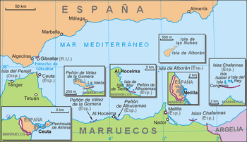
The plazas de soberanía (Spanish pronunciation: [ˈplaθaz ðe soβeɾaˈni.a], literally "places of sovereignty") are the Spanish sovereign territories in North Africa. These are separate pieces of land scattered along the Mediterranean coast bordering Morocco. The name refers to the fact that these territories have been a part of Spain since the formation of the modern Spanish State (1492–1556), and are distinguished from African territories obtained by Spain during the 19th and 20th century.
Historically, a distinction was made between the so-called "major sovereign territories", comprising the cities of Ceuta and Melilla, and the "minor sovereign territories", referring to a number of smaller enclaves and islands along the coast. In the present, the term refers mainly to the latter.
History

During the Reconquista and mainly following the conquest of Granada in 1492, forces of the Castilian and Portuguese kingdoms conquered and maintained numerous posts in North Africa for trade and as a defence against Barbary piracy.
In 1415 the Portuguese conquered Ceuta. In 1481 the Papal bull Æterni regis had granted all land south of the Canary Islands to Portugal. Only this archipelago and the possessions of Santa Cruz de la Mar Pequeña (1476–1524), Melilla (conquered by Pedro de Estopiñán in 1497), Villa Cisneros (founded in 1502 in current Western Sahara), Mazalquivir (1505), Peñón de Vélez de la Gomera (1508), Oran (1509–1790), Algiers (1510–1529), Bugia (1510–1554), Tripoli (1511–1551), and Tunis (1535–1569) remained as Spanish territory in Africa. Finally, following the independence of Portugal from Spain, Ceuta was ceded by Portugal to Spain in 1668.[1]
In 1848, Spanish troops conquered the Islas Chafarinas. In the late 19th century, after the so-called Scramble for Africa, European nations had taken over colonial control of most of the African continent. The Treaty of Fez (signed on March 30, 1912) made most of Morocco a protectorate of France, while Spain assumed the role of protecting power over the northern part, Spanish Morocco.[2]
When Spain relinquished its protectorate and recognized Morocco's independence in 1956, it did not give up these minor territories. Spain had held them well before the establishment of its protectorate.
On July 11, 2002, Morocco stationed six gendarmes on Perejil Island, which was at the time a source of complaint by Spain. The Spanish Armed Forces responded by launching a military operation code-named Operation Romeo-Sierra. The attack was carried out by Spanish commandos of Grupo de Operaciones Especiales. The Spanish Navy and Spanish Air Force provided support; the six Moroccan navy cadets did not offer any resistance and were captured and evicted from the island. It has since been evacuated by both countries.[3]
Physical geography
There are historically three plazas de soberanía:
Other islands
Apart from the three distinct groups, there are two other islands usually considered within the plazas de soberanía.
The disputed Isla Perejil, a small uninhabited islet close to Ceuta, considered by Spain to be a part of Ceuta and not a territory in its own right.[4]
The Isla de Alborán, another small island in the western Mediterranean, about 50 kilometres (31.05 miles) from the African coast and 90 kilometres (55.92 miles) from Europe, is attached to the municipality of Almería on the Iberian Peninsula.
Political geography
The plazas de soberanía are small islands and peninsulas off the coast of Morocco (the only peninsula, Peñón de Vélez de la Gomera, was an island until a 1934 storm formed a sand bridge with the mainland). They are guarded by military garrisons and administered directly by the Spanish central government.
Just like Ceuta and Melilla, they are a part of Spain, therefore also part of the European Union, and their currency is the euro.
Claimants
Morocco claims sovereignty over the Spanish North African territories, plus the autonomous cities of Ceuta and Melilla.
See also
- Spanish Africa (disambiguation)
- Spanish North Africa (disambiguation)
- Spanish Protectorate of Morocco
- List of Spanish Colonial Wars in Morocco
References
- ↑ da Silva, Rui A. M. "Treaties Galore". Olivença - Portugal Livre.
- ↑ "Treaty Between France and Spain Regarding Morocco". The American Journal of International Law. 7 (2): 81–99. April 1913. doi:10.2307/2212275. JSTOR 2212275.
- ↑ Ceberia Belaza, Monica; Ignacio Cembrero and Miguel González (17 September 2012). "The last remains of the empire". El Pais in English. Madrid. Retrieved 24 September 2012.
- ↑ Tremlett, Giles (13 July 2002). "Moroccans seize Parsley Island and leave a bitter taste in Spanish mouths". The Guardian. London. Retrieved 19 May 2014.
When officers from Spain's civil guard police force arrived on a small patrol boat from the nearby Spanish North African enclave of Ceuta three miles away and to which the islet nominally belongs...
Further reading
- Tremper, Shawn Del (1988). Territorial Disputes in the Strait of Gibralter [sic] (M.A. thesis, International Affairs). California State University, Sacramento. pp. 431 + bibliography. OCLC 19619469.
.svg.png)