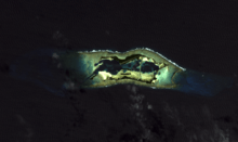
Palmyra Atoll
 Palmyra Atoll viewed from the northwest, 2011 | |
 Palmyra Atoll Location of Palmyra Atoll in the Pacific Ocean | |
| Geography | |
|---|---|
| Coordinates | 5°53′N 162°5′W / 5.883°N 162.083°WCoordinates: 5°53′N 162°5′W / 5.883°N 162.083°W |
| Archipelago | North Pacific |
| Total islands | 4 |
| Area | 12 km2 (4.6 sq mi) |
| Coastline | 14 km (8.7 mi) |
| Highest elevation | 1.8288 m (6 ft) |
| Administration | |
|
United States Palmyra Atoll is under the administration of the Office of Insular Affairs | |
| Demographics | |
| Population | 4–20 (2008) |
| Additional information | |
| Designated | April 1, 2011 |


.jpg)
Palmyra Atoll (/pælˈmaɪrə/) is an unoccupied equatorial Northern Pacific atoll administered as an unorganized incorporated territory by the United States federal government. The 12-square-kilometre (4.6 sq mi) territory hosts a variable temporary population of 4–25 "non-occupants", namely staff and scientists employed by various departments of the U.S. Government and by The Nature Conservancy, Inc.,[2] as well as a rotating mix of Palmyra Atoll Research Consortium[3] scholars pursuing research.
Geography
Palmyra is one of the Northern Line Islands (southeast of Kingman Reef and north of Kiribati Line Islands), located almost due south of the Hawaiian Islands, roughly one-third of the way between Hawaii and American Samoa. The nearest continent is almost 5400 km (3350 mi) to the northeast. The atoll is 4.6 sq mi (12 km2), and it is located in the equatorial Northern Pacific Ocean. Its 9 mi (14 km) of coastline has one anchorage known as West Lagoon.
The atoll consists of an extensive reef, two shallow lagoons, and some 50 sand and reef-rock islets and bars covered with vegetation—mostly Coconut trees, Scaevola, and tall Pisonia trees.
The islets of the atoll are mostly connected. Sand Island and the two Home Islets in the west and Barren Island in the east are not. The largest island is Cooper Island in the north, followed by Kaula Island in the south. The northern arch of islets is formed by Strawn Island, Cooper Island (or Cooper-Meng Island since former Cooper and Meng Islands were joined in 1940), Aviation Island, Quail Island, Whippoorwill Island, followed in the east by Eastern Island, Papala Island and Pelican Island, and in the south by Bird Island, Holei Island, Engineer Island, Tanager Island, Marine Island, Kaula Island, Paradise Island, the Home Islets and Sand Island (clockwise).
Climate
Average annual rainfall is approximately 175 in (4,400 mm) per year. Daytime temperatures average 85 °F (29 °C) year round.
Political status
Palmyra is an incorporated territory of the United States (the only such territory in existence since 1959), meaning that it is subject to all provisions of the U.S. Constitution and is permanently under American sovereignty. However, since Palmyra is also an unorganized territory, there is no Act of Congress specifying how Palmyra should be governed. Palmyra has no permanent residents; however, in 2004 accommodations were built to support a small number of temporary inhabitants.
The only relevant federal law simply gives the President the authority to administer Palmyra as directed, or via the United States District Court for the District of Hawaii (Hawaii Omnibus Act, Pub. L. 86–624, July 12, 1960, 74 Stat. 411).[4]
The issue of the governing of Palmyra is generally a moot point, since there is no permanent population remaining there, nor any reason to think that there will be in the future. Palmyra is the only unorganized incorporated territory of the United States. Cooper Island and ten other land parcels in this atoll are owned by The Nature Conservancy, Inc. which manages them as a nature reserve. The southwesternmost islets, including Home, are owned by descendants of former Palmyra owner Henry Ernest Cooper and others. The rest of Palmyra is federal land and waters under the jurisdiction of the U.S. Fish and Wildlife Service.[5] Since Palmyra has no state or local government, it is administered directly from Honolulu by the U.S. Fish and Wildlife Service, except for some submerged tracts administered by the Office of Insular Affairs, both in the U.S. Department of the Interior. For all other purposes, Palmyra is counted as one of the U.S. Minor Outlying Islands.
There is no current economic activity on Palmyra other than paid ecotourism visits and sport fishing by Nature Conservancy donors. Most of the roads and causeways there were built during World War II. All of these are now unserviceable and overgrown with bushes and grass, and most have washed-away gaps. There is a 2,000-yard (1,800 m)-long, unpaved, airstrip on Cooper Island (Palmyra (Cooper) Airport, ICAO code PLPA) that was built for the Palmyra Island Naval Air Station before and during World War II.
A construction program in 2004 erected several two-person bungalows and showers for the temporary residents. Fresh water is collected from the roof of a concrete building in this area. The communal buildings of the area on the south western coast of Cooper Island (the only occupied area of the atoll) consist of about half a dozen buildings next to the only sea dock.
Palmyra Atoll's location in the Pacific Ocean, where the southern and northern currents meet, means that its beaches are littered with trash and debris. Plastic mooring buoys and plastic bottles are plentiful on the beaches of Palmyra.
History


Palmyra was first sighted in 1798 by captain Edmund Fanning of Stonington, Connecticut, master of the American sealing ship Betsy, on a voyage to Asia, according to his published memoir 35 years later.[6] Fanning wrote that he had awakened three times during the night before. After the third time, he took it as a premonition, and he ordered Betsy to heave to for the rest of the night. The next morning, Betsy resumed sailing, but only about a nautical mile further on, and he believed that he sighted the reef later known as Palmyra Island. Had the ship continued on her course at night, the ship might have been wrecked.[7] (Captain Fanning's claim to have discovered Palmyra has been challenged, on the view that he had only reached Kingman Reef 34 miles away and could not possibly have seen Palmyra from that distance.[8])
On November 7, 1802, USS Palmyra under Captain Sawle was shipwrecked on the reef, which was given the name of this vessel. The remote atoll, lacking a navigable boat passage through the reef from the sea, had never been inhabited. No marae, basalt artifacts or evidence of Polynesian, Micronesian or other pre-European native settlements before 1802 have been found on Palmyra. Captain Sawle wrote:
There are no inhabitants on the island, nor was any fresh water found; but cocoanuts of a very large size, are in great abundance; and fish of various kinds and in large shoals surround the land.[9][10]
In 1859, Palmyra Atoll was claimed for the United States by Dr. Gerrit P. Judd of the brig Josephine, in accordance with the Guano Islands Act of 1856, but there was no guano there to be mined. On February 26, 1862, King Kamehameha IV of Hawaii commissioned Captain Zenas Bent and Johnson Beswick Wilkinson, both Hawaiian citizens, to take possession of the atoll. On April 15, 1862, it was formally annexed to the Kingdom of Hawaii, while Bent and Wilkinson became joint owners.[11]
Over the next century, ownership of the atoll passed through various hands. Bent sold his rights to Palmyra to Wilkinson on December 25, 1862. Palmyra later passed to Kalama Wilkinson (Johnson's widow). In 1885, it was then divided between three heirs, two of whom immediately sold their rights to William Luther Wilcox who, in turn, sold them to the Pacific Navigation Company. In 1897, this company was liquidated, and its interests were sold first to William Ansel Kinney, and then to Fred Wundenberg, all of Honlolulu.[12] On June 12, 1911, Wundenberg's widow sold his two-thirds undivided interest in Palmyra as a tenant in common to Judge Henry Ernest Cooper (1857–1929).[13]
A further Wilkinson heir left her share to her son William Ringer, Sr., who also bought his great-uncle's share, giving Ringer a total one-third undivided share in Palmyra as a tenant in common.[14]
Meanwhile, in 1889, Commander Nichols of HMS Cormorant claimed Palmyra for the United Kingdom, unaware of the prior claim made by Hawaii.[15]
In 1898, the United States by the Newlands Resolution annexed the Republic of Hawaii, formerly the Polynesian Kingdom of Hawaii, and Palmyra with it. An Act of Congress made all of Hawaii, including Palmyra, into an "incorporated territory" of the United States at that time. (Act of April 30, 1900, ch. 339, §§ 4-5.) On June 14, 1900, Palmyra became part of the new U.S. Territory of Hawaii.[11] To end all British claims, Congress passed a second act of annexation in 1911.
With imminent opening of the Panama Canal, Palmyra became strategically important. Britain had established a submarine cable station for the All Red Line on nearby Fanning Island.[16] So the U.S. Navy sent USS West Virginia to Palmyra, where on February 21, 1912, American sovereignty was formally reaffirmed.[11]
William Ringer, Sr. died in 1909 survived by his wife and three minor daughters. In 1912, Henry Ernest Cooper bought the daughters' inherited rights to Palmyra from their legal guardian and petitioned to register Torrens title to all of Palmyra for himself but, after a challenge in court, Cooper's ownership of the atoll was held by the Supreme Court of Hawaii to be subject to rights sold by Ringer's widow to Henry Maui and Joseph Clarke. Maui's and Clarke's interests, noted by the U.S. Supreme Court in 1947, were deeded as to one-third to Mrs. Bella Jones of Honolulu in 1912[17] and the rest passed to their heirs.[14]
Cooper visited the island in July 1913 with the scientists Charles Montague Cooke, Jr., and Joseph F. Rock, who wrote up a scientific description of the atoll. Botanist Rock discovered unusual Coconut Palms in 1913, which Palms expert Odoardo Beccari identified as Cocos nucifera palmyrensis (Becc.), the coconut type with the largest, longest and most triangular (in cross-section) fruits in the world, existing only at Palmyra. (The apparently closest Cocos nucifera relative occurs only in the distant Nicobar Islands in the Indian Ocean.)[18]
On August 19, 1922, Cooper sold his interest in the whole atoll except two minor islets to Leslie and Ellen Fullard-Leo for $15,000. They established the Palmyra Copra Company to harvest the coconuts growing on the atoll. Their three sons, including actor Leslie Vincent, continued as the owners afterwards, subject to a period of military administration and construction by the Navy before and during World War II from 1939 through 1945. In 2000, The Nature Conservancy, Inc. acquired the majority of Palmyra Atoll from the Fullard-Leo family for $30 million.[19]
U.S. Navy occupation (1934–1959)
In 1934, Johnston Atoll, Kingman Reef, and Palmyra were placed under the jurisdiction of the Department of the Navy.
On February 14, 1941, President Franklin Roosevelt issued Executive Order 8682 to create naval defenses areas in the central Pacific territories. The proclamation established "Palmyra Island Naval Defensive Sea Area" which encompassed the territorial waters between the extreme high-water marks and the three-mile marine boundaries surrounding the atoll. "Palmyra Island Naval Airspace Reservation" was also established to restrict access to the airspace over the naval defense sea area. Only U.S. government ships and aircraft were permitted to enter the naval defense areas at Palmyra Atoll unless authorized by the Secretary of the Navy.
The Navy took over the atoll for use as the Palmyra Island Naval Air Station on August 15, 1941. From November 1939 through 1947, the atoll had resident Federal Government representatives, the island commanders. The atoll was shelled by a Japanese submarine in 1941. The government made extensive alterations to the land forms. It blasted and dredged a ship channel from the open sea into the West Lagoon, which had been completely enclosed by islands and reef and was non-navigable until the channel reached the lagoon on May 15, 1941. It joined islands with causeway roads, built new islands and extended existing islands with dredged coral spoil, including the main runway on Cooper Island, an emergency landing strip called Sand Island joined by a causeway to Home Island, and two artificial runway islands that were not completed. These alterations blocked the water flow through the atoll and are believed to have severely harmed the natural ecology of the lagoons.[20]
After World War II, much of the Naval Air Station was demolished, with some of the materials piled up and burned on the atoll, dumped into the lagoon, or in the case of unexploded ordnance on some islets, just left in place.[21]
In 1939, the Fullard-Leos had asked rent for the U.S. Navy's use of Palmyra Atoll. During negotiations, the government filed a quiet title action against the Fullard-Leos and Henry Ernest Cooper's six surviving children, claiming that there had never been any private property at Palmyra under the Kingdom of Hawaii or later. The case went all the way up to the Supreme Court. The Fullard-Leos and Coopers finally won their case in United States v. Fullard-Leo et al., 331 U.S. 256 (1947), which quieted good land title against the federal government in favor of private landowners. The opinion acknowledged certain of Henry Maui's and Joseph Clarke's interests (331 U.S. 256 at 278) but their heirs and their successor Mrs. Bella Jones were not made parties to the case.[22] As of 2007, descendants of Henry Cooper still owned the two small islets not sold in 1922.[11]
Interior Department administration (1959–present)
When Hawaii was admitted to the United States in 1959, Palmyra was explicitly separated from the new state,[23] remaining a federal incorporated territory, administered by the Department of the Interior.[11] In 1962, the Department of Defense used Palmyra as an observation site during several high-altitude nuclear weapons tests high above Johnston Atoll. A group of about ten men supported the observation posts during this series of tests, while about 40 people carried out the observations.
In December 2000, most of Palmyra Atoll was bought by The Nature Conservancy, Inc.[11] for coral reef conservation and research. In 2003, a scientific study was published about fossilized coral that was washing up on Palmyra. This fossilized coral was examined for evidence of the behavior of the effect of El Niño on the tropical Pacific Ocean over the past 1,000 years.[24]
In November 2005, The Nature Conservancy established a new research station on Palmyra to study global warming, the disappearing coral reefs, invasive species, and other environmental concerns.[25]
The Pacific Remote Islands Marine National Monument, comprising Palmyra Atoll, Baker Island, Howland Island, Jarvis Island, Johnston Atoll and Kingman Reef, was established on January 6, 2009 by proclamation of President George W. Bush. The Secretary of the Interior has delegated the responsibility for supervising this National Monument to the U.S. Fish and Wildlife Service.[26]
Sovereignty challenges (1997–1999)
In the late 1990s, Rachel Lahela Kekoa Bolt, a native Hawaiian heir of Henry Maui, and some of her descendants filed federal lawsuits claiming her inherited interest in Palmyra and challenging the legality of the Newlands Resolution that annexed Hawaii in 1898 by simple majorities in Congress (after an Annexation Treaty had failed to get the required two-thirds majority in the U.S. Senate). The lawsuits challenged American sovereignty over both the State of Hawaii and the United States Territory of Palmyra Island.[27][28] On similar grounds they intervened in a federal marine salvage claim for a sunken treasure ship at Palmyra.[29] The cases were dismissed on procedural grounds before trial.
National Wildlife Refuge


On January 18, 2001, Secretary of the Interior Gale Norton signed an order designating Palmyra's tidal lands, submerged lands and surrounding waters out to 12 nautical miles (22 km) from the water's edge as a National Wildlife Refuge. Subsequently, the Department of the Interior published a regulation providing for the management of the refuge. 66 Fed. Reg. 7660-01 (January 24, 2001). The pertinent part of the regulation states as follows:
"We will close the refuge to commercial fishing but will permit a low level of compatible recreational fishing for bonefishing and deep water sportfishing under programs that we will carefully manage to ensure compatibility with refuge purposes. . . . Management actions will include protection of the refuge waters and wildlife from commercial fishing activities."
In March 2003, The Nature Conservancy conveyed 416 acres (1.68 km2) of the emergent land of Palmyra to the United States to be included in the refuge. In 2005, it subsequently added 28 more acres to the conveyance. The Nature Conservancy and Henry Ernest Cooper's descendants kept their remaining private land tracts at Palmyra.
The conveyance of Palmyra land to The Nature Conservancy, Inc. from the Fullard-Leos in 2000 was subject to a preexisting commercial fishing licence. Then in 2001 the Secretary of the Interior banned commercial fishing near Palmyra but allowed sport fishing, as quoted above. In January 2007, the commercial fishing licensees sued the United States in the Court of Federal Claims alleging that, under the Takings Clause, the Interior Department regulation had "directly confiscated, taken, and rendered wholly and completely worthless" their purported property interests. The United States filed a motion to dismiss the lawsuit, and the court granted the motion.[30] On April 9, 2009, the court's decision was affirmed by the Court of Appeals for the Federal Circuit.[31]
In 2011, the U.S. Fish and Wildlife Service, the Nature Conservancy, and Island Conservation began an extensive program to eradicate the large population of non-native rats that had arrived on Palmyra during World War II. As many as 30,000 rats once roamed the atoll, eating the eggs of native seabirds and destroying the seedlings of one of the largest remaining stands of Pisonia grandis trees in the Pacific. These efforts were successfully concluded in 2012 with respect to rodent removal; however, fifty-one animal samples representing 15 species of birds, fish, reptiles and invertebrates were collected for residue analysis during systematic searches or as nontarget mortalities. Brodifacoum residues (the toxicant employed during the project) were detected in most (84.3%) of the samples analyzed with unknown long-term and sublethal effects.[32][33]
Limited visits to the refuge are allowed, including by private recreational sailboat or motorboat. Visits must have prior approval, with access to Cooper Island arranged through the Nature Conservancy.[34]
The Sea Wind murder
In 1974, Palmyra was the site of a murder and possible double murder of a wealthy San Diego couple, Malcolm "Mac" Graham and his wife, Eleanor "Muff" Graham.[35] The mysterious deaths, murder conviction of Duane ("Buck") Walker (aka Wesley G. Walker) for Mrs. Graham's murder and the acquittal of his girlfriend, Stephanie Stearns, made headlines nationwide and led to a best-selling account written by Stearns's defense attorney, Vincent Bugliosi, and Bruce Henderson in the true crime book And the Sea Will Tell. The book led to a CBS television miniseries by the same name starring James Brolin, Rachel Ward and Hart Bochner. The story was also depicted in The FBI Files.
Walker and Stearns were arrested in Honolulu in 1974 after returning from Palmyra aboard Sea Wind, the yacht stolen from the Grahams. Because no bodies were found at the time, Walker and Stearns were convicted of only the yacht theft. Six years later, a partially buried corroded chest was found in a lagoon at Palmyra, containing Eleanor Graham's remains. Walker and Stearns were arrested in Arizona for murder. Walker was convicted in 1985. Stearns was acquitted in 1986 after her defense argued that Walker committed the murders without Stearns's knowledge. Walker served 22 years in the United States Penitentiary, Victorville, California before receiving parole in 2007. Walker died on April 26, 2010. Mac Graham disappeared and no body or other evidence of his death has been discovered, and his murder was not formally alleged.
See also
References
- ↑ "Palmyra Atoll". Office of Insular Affairs. US Department of Interior. Retrieved February 25, 2013.
- ↑ Sterling, Eleanor (July 28, 2010). "In the Middle of Nowhere, Snooping on Sea Turtles". New York Times. Scientist at Work blog. Retrieved September 28, 2010.
- ↑ Unattributed. "PARC Member Institutions". palmyraresearch.org. Retrieved September 28, 2010.
- ↑ "Public Law 86–624" (PDF) (PDF). July 12, 1960: 424 (14). Retrieved January 5, 2014.
shall be exercised in such manner and through such agency or agencies as the President of the United States may direct or authorize.
- ↑ https://www.cia.gov/library/publications/the-world-factbook/geos/um.html CIA World Fact Book
- ↑ Edmund Fanning (1924). Voyages and Discoveries in the South Seas 1792-1832. Salem, Massachusetts: Marine Research Society.
- ↑ Thomas, H.F., "Premonition of Danger" in "Connecticut Circle". Fate, March 1953; see also Gaddis, Vincent H. Invisible Horizons Ace Books, Inc., 1965.
- ↑ H. E. Maude (1961). ""Post-Spanish discoveries in the central Pacific"". Journal of the Polynesian Society. 70, No. 1: 67. Retrieved November 8, 2016.
- ↑ Capt. Sawle, Palmyra (September 6, 1806). "Letter to the Editor". Aurora for the Country. Philadelphia.
- ↑ "Report". The Naval Chronicle. XII. 1804. p. 464-465.
- 1 2 3 4 5 6 Department of the Interior, Office of Insular Affairs at the Wayback Machine (archived October 31, 2007)
- ↑ "Palmyra Island". The Evening Bulletin. Honolulu. August 14, 1897. Retrieved August 20, 2010.
- ↑ United States v. Fullard-Leo et al., 66 F.Supp. 774 (1940).
- 1 2 "Contest Cooper's Claim to Palmyra". The Hawaiian Gazette. Honolulu. May 3, 1912. Retrieved August 20, 2010.
- ↑ "Has Prior Claim: Palmyra Claimed by Kamehameha". The Hawaiian Gazette. Honolulu. August 13, 1897. Retrieved August 20, 2010.
- ↑ "Palmyra Title May Now be Tested: Sale of Fanning Brings the Little Hawaiian-Owned Group into Prominence". The Hawaiian Gazette. Honolulu. January 16, 1912. Retrieved August 20, 2010.
- ↑ Application No. 223 of Henry E. Cooper, Document No. 468, Hawaii Court of Land Registration (1912).
- ↑ Joseph F. Rock (April 1916). "Palmyra Island with a Description of its Flora". Bulletin Number 4. College of Hawaii.
- ↑ http://www.nature.org/ourinitiatives/regions/northamerica/unitedstates/hawaii/palmyraatoll/explore/the-nature-conservancy-in-palmyra-atoll-history.xml
- ↑ Collen, J. D.; Garton, D. W.; Gardner, J. P. A. (2000). "Shoreline Changes and Sediment Redistribution at Palmyra Atoll (Equatorial Pacific Ocean): 1874–Present". Journal of Coastal Research. Retrieved August 24, 2016.
- ↑ Palmyra Atoll: WWII Naval Air Station Contaminant Impacts on Terrestrial and Marine Ecosystems within the USFWS National Wildlife Refuge, Columbia Environmental Research Center, U.S. Geological Survey.
- ↑ "GAO/OGC-98-5 – U.S. Insular Areas: Application of the U.S. Constitution". U.S. Government Printing Office. November 7, 1997. Retrieved March 23, 2013.
- ↑ "Little Palmyra Atoll Isn't Celebrating". Daytona Beach Morning Journal. Daytona Beach. March 14, 1959. Retrieved 2015-09-29.
- ↑ K. M. Cobb et al., El Niño/Southern Oscillation and Tropic Pacific Climate During the Last Millennium, Nature, Vol. 424, July 17, 2003
- ↑ "Opening of The Nature Conservancy Research Station on Palmyra Atoll". Hawai'i Post. Retrieved August 20, 2010.
- ↑ "Pacific Remote Islands Marine National Monument". fws.gov. U.S. Fish and Wildlife Service. Retrieved July 31, 2009.
- ↑ Painter et al. v. United States et al., Case No. CV96-00685HG (D.C. Hawaii 1998).
- ↑ Painter v. United States et al., Case No. 1:98 CV-01737 (D.C. Dist.Col. 1999).
- ↑ William A. Warren v. Unidentified Wrecked Vessel, Case No. CV96-00018SPK (D.C. Hawaii 1998).
- ↑ Palmyra Pacific Seafoods, L.L.C. v. United States, 80 Fed. Cl. 228 (U.S. Court of Federal Claims 2008).
- ↑ Palmyra Pacific Seafoods, L.L.C. v. United States, 561 F.3d 1361 (Fed. Cir. 2009).
- ↑ Pitt, W.C.; Berentsen, A.R.; Volker, S.F.; Eisemann, J.D. (September 2012). "Palmyra Atoll Rainforest Restoration Project: Monitoring Results for the Application of Broadcast of Brodifacoum 25W: Conservation to Eradicate Rats" (PDF). QA-1875 Final Report. Hilo, Hawaii: USDA, APHIS, W, NWRC. Retrieved August 22, 2013.
- ↑ "Native species expected to rebound on rat-free Palmyra Atoll". Saipan Tribune (Press release). February 7, 2013. Retrieved August 22, 2013.
- ↑ "Palmyra Atoll – Plan Your Visit". fws.gov. U.S. Fish and Wildlife Service. Retrieved June 20, 2015.
- ↑ "Palmyra's scads of rats rival its crabs and birds". HonoluluAdvertiser.com.
Further reading
- Vincent Bugliosi and Bruce B. Henderson (1991/1992), And the Sea Will Tell, reprint, New York: Ballantine.
External links
| Wikimedia Commons has media related to Palmyra Atoll. |
- Palmyra Atoll photo gallery by FWS
- Palmyra atoll, Georgia Tech research
- The Curse of Palmyra Island – article
- The Nature Conservancy in Palmyra Atoll
- Palmyra Atoll Research Consortium
- WorldStatesmen – US Unincorporated possessions
- United States v. Fullard-Leo (Supreme Court opinion; includes a history of the island's ownership)
| Sovereign states |
| .svg.png) | |||||||||
|---|---|---|---|---|---|---|---|---|---|---|---|
Dependencies and other territories |
| ||||||||||